1960s Maps of Massena, New York
Explore 5 historic maps of Massena from the 1960s. These maps offer a rare glimpse into what life looked like during the 1960s — showing old roads, neighborhoods, homes, and landmarks that have changed or disappeared over time.
Whether you're researching your family's past, planning a metal detecting trip, or studying how Massena's landscape evolved across the 1960s, these high-resolution maps are a powerful tool for exploring the history of this region.
- Focus on a specific era: All maps on this page are from the 1960s, giving you a focused view of this time period.
- See what’s changed: Compare century-old streets, trails, and buildings to today's modern landscape using overlays and satellite layers.
- Research with precision: Use these maps for genealogy, historical research, land use analysis, or educational projects.
- View, download, or print: Maps are fully viewable online in high resolution, and can be downloaded or printed for your own records.
Start exploring Massena's history through authentic maps from the 1960s. This is your window into the past.
Massena, NY maps
(5)- 1961 Map of Ogdensburg
 1961 Ogdensburg1961 Print · USGSThe St. Lawrence valley and the Adirondack high country meet in this early sixties survey during a peak era for rail and river commerce. Genealogists and historians can trace the paths of the New York Central railroad through remote settlements like Wanakena, Conifer, and Piercefield.
 - 1964 Map of Raquette River, 1966 Print
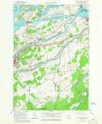 1964 Raquette River1966 Print · USGSThe St. Lawrence riverfront in the mid-1960s shows a landscape transformed by the seaway and international commerce. Local historians can trace family-named roads and sites like Massena Center, the Eisenhower Lock, and Carville Cem.2 unique versions available
 - 1964 Map of Massena, 1966 Print
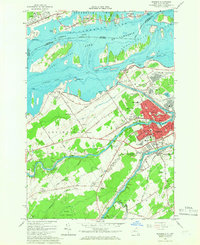 1964 Massena1966 Print · USGSSt. Lawrence County in the mid-1960s reveals a landscape defined by the St. Lawrence Seaway and industrial growth. Genealogists and historians can trace family locations near Massena Springs, Calvary Cem, or schools like Madison Sch.3 unique versions available
 - 1964 Map of Hogansburg, 1966 Print
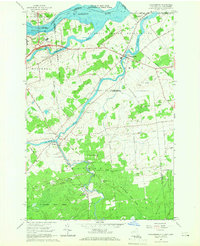 1964 Hogansburg1966 Print · USGSThe St. Lawrence borderlands in the mid-1960s are defined by the convergence of three major rivers and the Akwesasne territory. Genealogists and historians can trace the foundations of local industry at Brasher Iron Works or locate heritage sites like St Regis Ch and Mohawk Memorial Cem.3 unique versions available
 - 1964 Map of Cornwall West, 1974 Print
 1964 Cornwall West1974 Print · USGSThe international border at the St. Lawrence River was undergoing massive infrastructure changes in the mid-sixties. Researchers can trace the layout of Cornwall, the engineering of the Moses-Saunders Dam, and rural settlements like Eamers Corners.
End of results
Showing maps 1-5 of 5
Top cities near Massena
- Potsdam historical maps
- Massena historical maps
- Norfolk historical maps
- Stockholm historical maps
- Louisville historical maps
- Moira historical maps
See more
Top neighborhoods of Massena
- Raquette River historical maps
- Rooseveltown historical maps
- Massena Center historical maps
- Massena historical maps
Frequently asked questions
- What are the different types of historical maps available for Massena?
- What is the oldest map of Massena?
- Where can I purchase historical maps of Massena for my home or office?
- Where can I download high-res historical maps of Massena?
- Are there historical topographic maps available for Massena?
- Is there historical aerial imagery available for Massena?
- Where are historical maps of Massena sourced from?