1900s (20th Century) Maps of Suffolk County, New York
Explore 159 historic maps of Suffolk County from the 1900s (20th Century). These maps offer a rare glimpse into what life looked like during the 1900s — showing old roads, neighborhoods, homes, and landmarks that have changed or disappeared over time.
Whether you're researching your family's past, planning a metal detecting trip, or studying how Suffolk County's landscape evolved across the 1900s, these high-resolution maps are a powerful tool for exploring the history of this region.
- Focus on a specific era: All maps on this page are from the 1900s, giving you a focused view of this time period.
- See what’s changed: Compare century-old streets, trails, and buildings to today's modern landscape using overlays and satellite layers.
- Research with precision: Use these maps for genealogy, historical research, land use analysis, or educational projects.
- View, download, or print: Maps are fully viewable online in high resolution, and can be downloaded or printed for your own records.
Start exploring Suffolk County's history through authentic maps from the 1900s. This is your window into the past.
Suffolk County, NY maps
(159)- 1901 Map of Babylon, 1958 Print
 1901 Babylon1958 Print · USGSThe South Shore of Long Island at the turn of the century shows a landscape of rail-linked villages and tidal marshes. Trace early transit hubs like Bethpage Junc. and maritime outposts such as the Zachs Inlet L.S.S. along the coast.
 - 1901 Map of Northport, 1962 Print
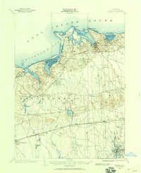
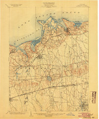
 1901 Northport1962 Print · USGSThe North Shore of Long Island is captured here at the turn of the century, showing a landscape defined by deep harbors and maritime navigation. You can trace the early rail routes of the Long Island RR and locate historic coastal landmarks like Eatons Neck L.H. and Fort Salonga.
 - 1902 Map of Setauket, 1959 Print
 1902 Setauket1959 Print · USGSSuffolk County’s north and south shores are captured here at the start of the twentieth century. Researchers can trace the Port Jefferson Branch rail lines, the grounds of the State Hospital, and the early layout of Setauket and Bohemia.
 - 1902 Map of Fire Island, 1962 Print
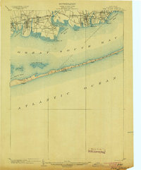
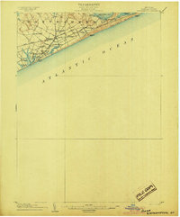
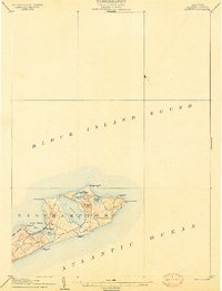
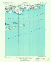 1902 Fire Island1962 Print · USGSThe South Shore of Long Island is captured here at the dawn of the twentieth century, anchored by the Montauk Division rail line. Genealogists and maritime historians can locate early settlements like Oakdale and trace the vital network of Life-Saving Stations including Point O'Woods L.S.S. and Blue Point L.S.S. along the barrier beach.
 - 1903 Map of Babylon
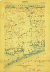
 1903 Babylon1903 Print · USGSSouthern Suffolk County coastal life and rail expansion are captured here at the turn of the century. Genealogists and historians can trace early residential clusters around Amityville or locate coastal landmarks like Oak Island L.S.S. and Bethpage Junc.8 unique versions available
 - 1903 Map of Northport
 1903 Northport1903 Print · USGSThe North Shore of Long Island at the turn of the century reveals a landscape defined by deep harbors and the expanding railroad. Genealogists and historians can trace the early layouts of Northport and Huntington, or locate landmarks like Eaton Neck L.H. and Kings Park.8 unique versions available
 - 1903 Map of Fire Island
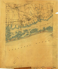
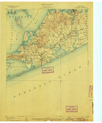
 1903 Fire Island1903 Print · USGSLong Island's southern shore and the outer barrier beach are captured here at the turn of the century. You can trace early coastal infrastructure through the Fire Island Lighthouse and life-saving stations like Lone Hill L.S.S. and Blue Point L.S.S..6 unique versions available
 - 1903 Map of Sag Harbor, 1961 Print
 1903 Sag Harbor1961 Print · USGSThe South Fork of Long Island at the start of the century reveals a coastal landscape of rail-linked hamlets and active life-saving stations. Researchers can trace the early layout of the Shinnecock Indian Reservation and locate historic stops like Wainscott Sta along the Long Island Railroad.
 - 1903 Map of Gardiners Island, 1962 Print
 1903 Gardiners Island1962 Print · USGSThe eastern reaches of Long Island and its surrounding sounds appear here at the opening of the twentieth century. Researchers can trace historic shorelines and maritime infrastructure, including Fort Terry on Plum Island and old settlements like Kingstown and Fireplace.
 - 1903 Map of Riverhead, 1963 Print
 1903 Riverhead1963 Print · USGSThe forks of Long Island come alive in this early 1900s survey of the bustling rail and maritime corridor. Researchers can trace the Long Island Railroad through historic hamlets like Good Ground, Aquebogue, and the early shoreline of Shinnecock Bay.
 - 1904 Map of Setauket
 1904 Setauket1904 Print · USGSSuffolk County at the start of the century shows a North Shore landscape of maritime villages and inland rail depots. Genealogists can trace family names and institutions from Stony Brook to the State Hospital For The Insane and Patchogue.7 unique versions available
 - 1904 Map of Islip
 1904 Islip1904 Print · USGSSuffolk County at the start of the century reveals a landscape defined by deep north-shore harbors and the expansive Great South Bay. Genealogists and local historians can trace early rail lines through Kings Park and Stony Brook, or locate the sprawling State Hospital and St. Dominic Convent.5 unique versions available
 - 1904 Map of Sag Harbor
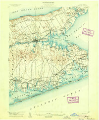
 1904 Sag Harbor1904 Print · USGSThe South Fork of Long Island at the dawn of the 1900s reveals a maritime landscape of life-saving stations and rail-connected villages. Genealogists and historians can trace the early layout of Sag Harbor, the Montauk Division railroad stops, and the Shinnecock Indian Reservation.6 unique versions available
 - 1904 Map of Shelter Island
 1904 Shelter Island1904 Print · USGSEastern Long Island thrived at the dawn of the twentieth century as a premier maritime and rail destination. Trace the coastal growth of Sag Harbor and Greenport or locate family landmarks along the Long Island RR and at Orient Point.6 unique versions available
 - 1904 Map of Easthampton
 1904 Easthampton1904 Print · USGSThe eastern reaches of Long Island at the turn of the century show a maritime landscape of small hamlets and life-saving stations. Genealogists and historians can trace the early rail corridor of the Long Island R. R. and locate family-named settlements like Freetown, Jericho, and Pantigo.6 unique versions available
 - 1904 Map of Gardiners Island
 1904 Gardiners Island1904 Print · USGSEasthampton and its outlying islands are captured here in the early twentieth century, showing a maritime landscape defined by coastal forts and small harbor landings. Genealogists and local historians can trace family-named sites like Barnes Landing, Springs, and the military outpost at Fort Terry.6 unique versions available
 - 1904 Map of Riverhead
 1904 Riverhead1904 Print · USGSEastern Long Island at the turn of the century shows a landscape of rail-connected hamlets and coastal vigilance. Researchers can trace the early layout of Riverhead or locate historic life-saving outposts like Tiana L.S.S. and Potunk L.S.S. along the barrier beaches.9 unique versions available
 - 1904 Map of Montauk
 1904 Montauk1904 Print · USGSThe tip of Long Island at the turn of the century is a maritime frontier where the railway meets the Atlantic. Researchers can trace the early layout of Montauk, the vital Montauk Point L.H., and coastal life-saving stations like Ditch Plain L.S.S.6 unique versions available
 - 1904 Map of Moriches, 1912 Print
 1904 Moriches1912 Print · USGSCoastal Suffolk County at the start of the century shows a landscape of quiet maritime landings and early railroad hamlets. Genealogists can trace the early footprints of Wardenclyffe, Middle Island, and the Life-Saving Stations protecting Fire Island.2 unique versions available
 - 1919 Map of Setauket
 1919 Setauket1919 Print · USGSLong Island's north and south shores meet in this post-war tactical survey, documenting the transition from maritime villages to rail-linked townships. Genealogists and researchers can trace early century landmarks like the State Hospital for the Insane and the original Setauket Sta.
 - 1919 Map of Babylon
 1919 Babylon1919 Print · USGSThe South Shore of Long Island is captured here during a period of steady growth between the world wars. Genealogists and local historians can trace early transportation routes like the Motor Parkway and locate coastal landmarks such as the Oak Island L.S.S. and St. Dominic Convent.
 - 1920 Map of Bridgeport
 1920 Bridgeport1920 Print · USGSCoastal Connecticut comes alive in the early twentieth century as a hub of maritime commerce and industrial growth. Researchers can trace the development of Bridgeport and Milford, or locate specific landmarks like Charles Island and Beardsley Park.
 - 1921 Map of Gardiners Island
 1921 Gardiners Island1921 Print · USGSThe maritime landscape of eastern Long Island is detailed here in the years following the Great War. Researchers can trace historic shorelines and landings like Quincetree Landing, locate the military grounds of Fort Terry, or find family-named sites such as Barnes Landing and Hicks.
 - 1921 Map of New London
 1921 New London1921 Print · USGSCoastal Connecticut thrived between the world wars as a strategic naval and rail hub. Genealogists and historians can trace the foundations of local life through the Norwich State Hospital, the sprawling US Naval Station, and small hamlets like Gales Ferry or Flanders Village.
 - 1921 Map of Easthampton
 1921 Easthampton1921 Print · USGSThe eastern tip of Long Island comes alive in the early twentieth century, showing a maritime landscape defined by rail and sea. Genealogy and history buffs can trace the Long Island R. R. through Easthampton or locate the coastal Georgica L.S.S. and the settlement at Promised Land.
Showing maps 1-25 of 159
Top cities of Suffolk County
- Brookhaven historical maps
- Islip historical maps
- Babylon historical maps
- Huntington historical maps
- Smithtown historical maps
- Southampton historical maps
See more
Frequently asked questions
- What are the different types of historical maps available for Suffolk County?
- What is the oldest map of Suffolk County?
- Where can I purchase historical maps of Suffolk County for my home or office?
- Where can I download high-res historical maps of Suffolk County?
- Are there historical topographic maps available for Suffolk County?
- Is there historical aerial imagery available for Suffolk County?
- Where are historical maps of Suffolk County sourced from?