1940s Maps of Suffolk County, New York
Explore 45 historic maps of Suffolk County from the 1940s. These maps offer a rare glimpse into what life looked like during the 1940s — showing old roads, neighborhoods, homes, and landmarks that have changed or disappeared over time.
Whether you're researching your family's past, planning a metal detecting trip, or studying how Suffolk County's landscape evolved across the 1940s, these high-resolution maps are a powerful tool for exploring the history of this region.
- Focus on a specific era: All maps on this page are from the 1940s, giving you a focused view of this time period.
- See what’s changed: Compare century-old streets, trails, and buildings to today's modern landscape using overlays and satellite layers.
- Research with precision: Use these maps for genealogy, historical research, land use analysis, or educational projects.
- View, download, or print: Maps are fully viewable online in high resolution, and can be downloaded or printed for your own records.
Start exploring Suffolk County's history through authentic maps from the 1940s. This is your window into the past.
Suffolk County, NY maps
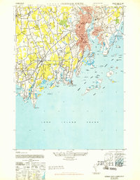
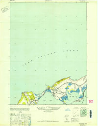
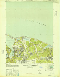
(45)- 1941 Map of Bay Shore West
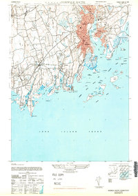
 1941 Bay Shore West1941 Print · USGSCoastal Suffolk County comes to life during the early 1940s, showing the South Shore villages as the Long Island suburb began to take shape. Researchers can trace the layout of early school districts like the Union Free Sch or find local landmarks such as the Babylon Yacht Club and St Patricks Ch.
 - 1942 Map of Montauk Point
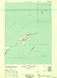
 1942 Montauk Point1942 Print · USGSThe tip of Long Island comes into focus during the early 1940s as a vital coastal and maritime hub. Researchers can trace the Long Island railroad line to its terminus and locate specific landmarks like the Lighthouse and Ditch Plain LSS.
 - 1942 Map of Islip, 1943 Print
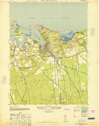
 1942 Islip1943 Print · USGSCentral Suffolk County is shown during the early years of the war, as the automobile began to reshape the distance between historic North Shore harbors and the South Shore bays. Researchers can trace the path of the Long Island Motor Parkway, locate family plots at Pinelawn Cem, and identify coastal landmarks like Eaton Neck L H.
 - 1942 Map of Block Island, 1943 Print
 1942 Block Island1943 Print · USGSThe coastal borderlands of Rhode Island and Connecticut are captured here during the wartime years, documenting a landscape defined by rail and sea. Researchers can trace the NY NH & H RR through historic mill villages or locate landmarks like the Silex Mine and Indian Burying Hill.2 unique versions available
 - 1943 Map of Riverhead
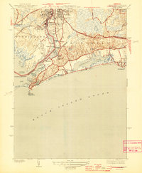
 1943 Riverhead1943 Print · USGSLong Island's eastern forks appear here in the early twentieth century as a landscape of coastal hamlets and maritime commerce. Trace the path of the Montauk Division railroad through RIVERHEAD or locate family roots in Mattituck, Speonk, and Good Ground.
 - 1943 Map of Norwalk South, 1947 Print
 1943 Norwalk South1947 Print · USGSThe Connecticut shoreline in the 1940s reveals a landscape of growing suburban towns and busy coastal rails. Trace the historic waterfronts of South Norwalk and Darien or explore offshore landmarks like Sheffield Island and Cockenoe Island.
 - 1943 Map of Gardiners Island East, 1947 Print
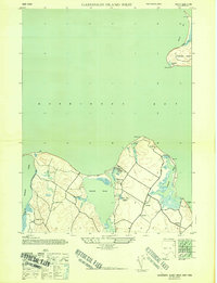
 1943 Gardiners Island East1947 Print · USGSGardiners Island and the East Hampton shoreline are captured here during the 1940s. Researchers can trace the Long Island Railroad corridor and explore old coastal landmarks like Quince Tree Landing, Cartwright Island, and Great Pond.
 - 1944 Map of Bay Shore East
 1944 Bay Shore East1944 Print · USGSThe Long Island shoreline near Bay Shore and Islip is captured here during the 1940s. Researchers can trace the development of barrier island communities like Ocean Beach and Point O' Woods or locate the historic Fire Island Coast Guard station.
 - 1944 Map of Mystic
 1944 Mystic1944 Print · USGSCoastal Connecticut and the waters of Fishers Island Sound are captured here during the mid-war years. Researchers can trace historic family cemeteries like Elm Grove Cem and Miner Cem, or locate the Stonington Landing Field.3 unique versions available
 - 1944 Map of Watch Hill
 1944 Watch Hill1944 Print · USGSCoastal Rhode Island and Connecticut meet along the Pawcatuck River during the mid-forties. Genealogists and historians can trace the neighborhoods of Pawcatuck, find family plots in River Bend Cem, or locate the Watch Hill Lighthouse along the sound.2 unique versions available
 - 1944 Map of Gardiners Island West, 1947 Print
 1944 Gardiners Island West1947 Print · USGSThe East Hampton shoreline during the 1940s reveals a quiet landscape of coastal hamlets and protected inlets. Genealogists and researchers can trace local routes through Springs and Eastside, or locate family landmarks like Powder Hill and Fireplace.2 unique versions available
 - 1946 Map of Sag Harbor
 1946 Sag Harbor1946 Print · USGSThe South Fork of Long Island at the end of the war years shows a landscape of coastal hamlets and large estates. Trace family names on rural lanes near Bridgehampton or locate early aviation landmarks like Hampton Airport and Easthampton Airport.
 - 1947 Map of Orient
 1947 Orient1947 Print · USGSThe tip of Long Island's North Fork is captured here in the late 1940s, showing a landscape defined by saltwater bays and narrow peninsulas. Genealogists and local historians can trace the homes around ORIENT and East Marion, or locate family plots in the CENTRAL CEMETERY.
 - 1947 Map of St James
 1947 St James1947 Print · USGSThe North Shore of Long Island is captured here in the years following the war, featuring the intricate tidal marshlands of Smithtown Bay. Genealogists and historians can trace the grounds of the Kings Park State Hospital for the Insane and the residential clusters at St. James and Stony Brook.2 unique versions available
 - 1947 Map of Bellport
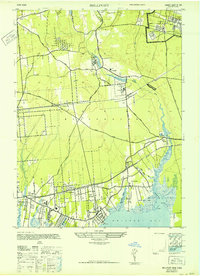 1947 Bellport1947 Print · USGSThe South Shore of Long Island in the late 1940s is shown here at the cusp of significant change. Genealogists and historians can trace rail-era landmarks like Yaphank Sta, the Suffolk County Alms House & Childrens Home, and the Camp Upton Military Reservation.
 - 1947 Map of Mattituck
 1947 Mattituck1947 Print · USGSNorth and South Fork communities are captured here in the mid-1940s as the Long Island Railroad connects rural farmlands to the bays. Genealogists and local historians can trace family-named sites like Squiretown, Northville, and Jacobs Hill across this unique double-shoreline landscape.
 - 1947 Map of Howells Point
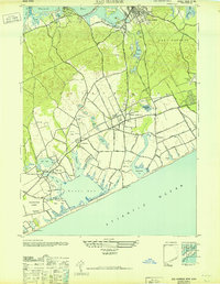
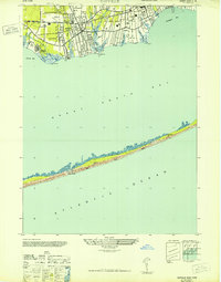
 1947 Howells Point1947 Print · USGSThe South Shore of Long Island is documented here in the late forties, showing the vulnerable barrier beach system before modern development. Researchers can trace the early residential layout of Brookhaven and the natural state of Great South Beach and Ridge Island.
 - 1947 Map of Mattituck Hills
 1947 Mattituck Hills1947 Print · USGSThe North Fork of Long Island comes into focus during the late 1940s, showing a landscape of coastal bluffs and fertile farmland. Researchers can trace family-named roads like Alvans Lane and Elijans Lane or locate landmarks like Mattituck Light and Waterville.
 - 1947 Map of Plum Island
 1947 Plum Island1947 Print · USGSCoastal Suffolk County is captured here just after the war, detailing the military footprint on the islands between the sounds. Researchers can trace the layout of Fort Terry and locate maritime landmarks like the Lighthouse and the Ferry Landing.2 unique versions available
 - 1947 Map of Northport
 1947 Northport1947 Print · USGSNorthport and the surrounding North Shore communities are captured in the late 1940s during a period of significant growth. Researchers can trace family estates and local institutions from the W K Vanderbilt Estate to the Northport Rural Cem and St Josephs Ch & Sch.
 - 1947 Map of Port Jefferson
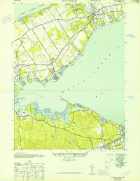
 1947 Port Jefferson1947 Print · USGSMid-century coastal Long Island comes into focus in this study of the North Shore harbors just after the war. Researchers can trace the waterfront development of Port Jefferson and identify early land use in Setauket, Mount Sinai, and Belle Terre.
 - 1947 Map of Southold
 1947 Southold1947 Print · USGSThe North Fork of Long Island comes into focus during the mid-1940s, showing a world of waterfront estates, maritime commerce, and railroad villages. Genealogists and local historians can trace family-named sites like Horton Pt Lighthouse, the Cutchogue Sta depot, and Founders Ldg.
 - 1947 Map of Central Islip
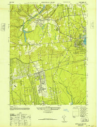 1947 Central Islip1947 Print · USGSSuffolk County is captured in the mid-1940s as institutional grounds and early aviation hubs began to reshape the Long Island interior. Researchers can trace the sprawling grounds of the Central Islip State Hospital and the early layout of Islip Airport.
 - 1947 Map of Sayville
 1947 Sayville1947 Print · USGSThe South Shore of Long Island is captured here in the late 1940s, showing a landscape of maritime villages and coastal retreats. Researchers can trace the development of Sayville and Bayport or locate remote landmarks like Cherry Grove and the Blue Point CG on the barrier beach.
 - 1947 Map of Norwalk South
 1947 Norwalk South1947 Print · USGSCoastal Fairfield County's post-war shoreline comes to life here, showing the intricate geography of the Norwalk Islands and growing railroad suburbs. Genealogists and historians can trace family locations through Noroton, Darien, and the unique grounds of the Ferndale Retreat.
Showing maps 1-25 of 45
Top cities of Suffolk County
- Brookhaven historical maps
- Islip historical maps
- Babylon historical maps
- Huntington historical maps
- Smithtown historical maps
- Southampton historical maps
See more
Frequently asked questions
- What are the different types of historical maps available for Suffolk County?
- What is the oldest map of Suffolk County?
- Where can I purchase historical maps of Suffolk County for my home or office?
- Where can I download high-res historical maps of Suffolk County?
- Are there historical topographic maps available for Suffolk County?
- Is there historical aerial imagery available for Suffolk County?
- Where are historical maps of Suffolk County sourced from?