Old Maps of Suffolk County, New York for Academic Research
Study the evolution of Suffolk County with 420 high-resolution historic maps. Whether you're teaching, researching, or modeling changes in land use, these maps provide essential visual documentation of urban, environmental, and geographic change.
- Analyze long-term change: Track patterns in development, transportation, and natural features.
- Ideal for environmental or urban studies: Support academic projects with primary historical map data.
- Use in the classroom or lab: Educators and researchers rely on these maps to bring historical context to life.
These maps are a powerful tool for teaching, research, and visualizing how Suffolk County has changed over the decades.
Suffolk County, NY maps
(420)- 1889 Map of Stonington
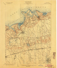
 1889 Stonington1889 Print · USGSThe Connecticut and Rhode Island borderlands are documented here at the height of the maritime and rail era. Genealogists and historians can trace family-named hills like Stewart Hill or locate industrial sites such as the Silax Mine and the rail hub at Mystic Bridge.
 - 1891 Map of Bridgeport
 1891 Bridgeport1891 Print · USGSThe industrial shoreline of Fairfield County comes to life in this late Victorian survey, capturing the region's intense rail and maritime activity. Trace the early street grids of Bridgeport and Milford, or locate family landmarks near Moodys Mill Pond and Nichols Farms.
 - 1892 Map of Norwalk
 1892 Norwalk1892 Print · USGSThe Fairfield County coastline and its rural hinterlands are seen here in the late nineteenth century, showing the early density of harbor towns and scattered ridge-top farms. Genealogists can trace family lands near Greenfield Hill or follow the rails to the Five Mile River Sta. and Winnipauk.
 - 1892 Map of New London
 1892 New London1892 Print · USGSCoastal Connecticut at the close of the nineteenth century reveals a landscape defined by its deep-water harbor and expanding rail networks. Genealogists and historians can trace old property lines and neighborhoods near Ft Trumbull, Gale Ferry, and Flanders Village.
 - 1893 Map of Bridgeport
 1893 Bridgeport1893 Print · USGSCoastal Connecticut thrived in the 1890s as a hub of manufacturing and rail transport. Genealogists and historians can trace the early street grids of Bridgeport, find old landmarks like Berkshire Mill Pond, and locate family sites in Nichols Farms.8 unique versions available
 - 1893 Map of Norwalk
 1893 Norwalk1893 Print · USGSThe Connecticut coastline thrives in the 1890s as a hub of rail transit and maritime trade. Genealogists and local researchers can trace old family landmarks across Belden Hill, the historic centers of Norwalk, and the early stops of the Danbury and Norwalk R.R.12 unique versions available
 - 1893 Map of Stonington
 1893 Stonington1893 Print · USGSThe coastal borderlands of Connecticut and Rhode Island are captured here in the late nineteenth century, showing a landscape defined by maritime trade and river power. Genealogists can trace family landmarks like Ayer Hill and Pequot Hill or locate industrial sites such as the Silex Mine.10 unique versions available
 - 1893 Map of New London
 1893 New London1893 Print · USGSSoutheastern Connecticut at the height of the Victorian era centers on the busy maritime hub of New London and its strategic harbor. Genealogists can trace family holdings and early industry from Gale Ferry to Poquonoc Bridge, while rail enthusiasts can follow the Shore Line Division across the coast.10 unique versions available
 - 1901 Map of Babylon, 1958 Print
 1901 Babylon1958 Print · USGSThe South Shore of Long Island at the turn of the century shows a landscape of rail-linked villages and tidal marshes. Trace early transit hubs like Bethpage Junc. and maritime outposts such as the Zachs Inlet L.S.S. along the coast.
 - 1901 Map of Northport, 1962 Print
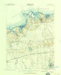
 1901 Northport1962 Print · USGSThe North Shore of Long Island is captured here at the turn of the century, showing a landscape defined by deep harbors and maritime navigation. You can trace the early rail routes of the Long Island RR and locate historic coastal landmarks like Eatons Neck L.H. and Fort Salonga.
 - 1902 Map of Setauket, 1959 Print
 1902 Setauket1959 Print · USGSSuffolk County’s north and south shores are captured here at the start of the twentieth century. Researchers can trace the Port Jefferson Branch rail lines, the grounds of the State Hospital, and the early layout of Setauket and Bohemia.
 - 1902 Map of Fire Island, 1962 Print
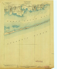
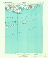 1902 Fire Island1962 Print · USGSThe South Shore of Long Island is captured here at the dawn of the twentieth century, anchored by the Montauk Division rail line. Genealogists and maritime historians can locate early settlements like Oakdale and trace the vital network of Life-Saving Stations including Point O'Woods L.S.S. and Blue Point L.S.S. along the barrier beach.
 - 1903 Map of Babylon
 1903 Babylon1903 Print · USGSSouthern Suffolk County coastal life and rail expansion are captured here at the turn of the century. Genealogists and historians can trace early residential clusters around Amityville or locate coastal landmarks like Oak Island L.S.S. and Bethpage Junc.8 unique versions available
 - 1903 Map of Northport
 1903 Northport1903 Print · USGSThe North Shore of Long Island at the turn of the century reveals a landscape defined by deep harbors and the expanding railroad. Genealogists and historians can trace the early layouts of Northport and Huntington, or locate landmarks like Eaton Neck L.H. and Kings Park.8 unique versions available
 - 1903 Map of Fire Island
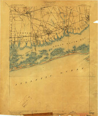
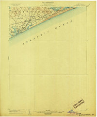
 1903 Fire Island1903 Print · USGSLong Island's southern shore and the outer barrier beach are captured here at the turn of the century. You can trace early coastal infrastructure through the Fire Island Lighthouse and life-saving stations like Lone Hill L.S.S. and Blue Point L.S.S..6 unique versions available
 - 1903 Map of Sag Harbor, 1961 Print
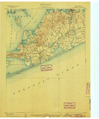
 1903 Sag Harbor1961 Print · USGSThe South Fork of Long Island at the start of the century reveals a coastal landscape of rail-linked hamlets and active life-saving stations. Researchers can trace the early layout of the Shinnecock Indian Reservation and locate historic stops like Wainscott Sta along the Long Island Railroad.
 - 1903 Map of Gardiners Island, 1962 Print
 1903 Gardiners Island1962 Print · USGSThe eastern reaches of Long Island and its surrounding sounds appear here at the opening of the twentieth century. Researchers can trace historic shorelines and maritime infrastructure, including Fort Terry on Plum Island and old settlements like Kingstown and Fireplace.
 - 1903 Map of Riverhead, 1963 Print
 1903 Riverhead1963 Print · USGSThe forks of Long Island come alive in this early 1900s survey of the bustling rail and maritime corridor. Researchers can trace the Long Island Railroad through historic hamlets like Good Ground, Aquebogue, and the early shoreline of Shinnecock Bay.
 - 1904 Map of Setauket
 1904 Setauket1904 Print · USGSSuffolk County at the start of the century shows a North Shore landscape of maritime villages and inland rail depots. Genealogists can trace family names and institutions from Stony Brook to the State Hospital For The Insane and Patchogue.7 unique versions available
 - 1904 Map of Islip
 1904 Islip1904 Print · USGSSuffolk County at the start of the century reveals a landscape defined by deep north-shore harbors and the expansive Great South Bay. Genealogists and local historians can trace early rail lines through Kings Park and Stony Brook, or locate the sprawling State Hospital and St. Dominic Convent.5 unique versions available
 - 1904 Map of Sag Harbor
 1904 Sag Harbor1904 Print · USGSThe South Fork of Long Island at the dawn of the 1900s reveals a maritime landscape of life-saving stations and rail-connected villages. Genealogists and historians can trace the early layout of Sag Harbor, the Montauk Division railroad stops, and the Shinnecock Indian Reservation.6 unique versions available
 - 1904 Map of Shelter Island
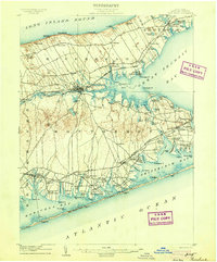
 1904 Shelter Island1904 Print · USGSEastern Long Island thrived at the dawn of the twentieth century as a premier maritime and rail destination. Trace the coastal growth of Sag Harbor and Greenport or locate family landmarks along the Long Island RR and at Orient Point.6 unique versions available
 - 1904 Map of Easthampton
 1904 Easthampton1904 Print · USGSThe eastern reaches of Long Island at the turn of the century show a maritime landscape of small hamlets and life-saving stations. Genealogists and historians can trace the early rail corridor of the Long Island R. R. and locate family-named settlements like Freetown, Jericho, and Pantigo.6 unique versions available
 - 1904 Map of Gardiners Island
 1904 Gardiners Island1904 Print · USGSEasthampton and its outlying islands are captured here in the early twentieth century, showing a maritime landscape defined by coastal forts and small harbor landings. Genealogists and local historians can trace family-named sites like Barnes Landing, Springs, and the military outpost at Fort Terry.6 unique versions available
 - 1904 Map of Riverhead
 1904 Riverhead1904 Print · USGSEastern Long Island at the turn of the century shows a landscape of rail-connected hamlets and coastal vigilance. Researchers can trace the early layout of Riverhead or locate historic life-saving outposts like Tiana L.S.S. and Potunk L.S.S. along the barrier beaches.9 unique versions available
Showing maps 1-25 of 420
Top cities of Suffolk County
- Brookhaven historical maps
- Islip historical maps
- Babylon historical maps
- Huntington historical maps
- Smithtown historical maps
- Southampton historical maps
See more
Frequently asked questions
- What are the different types of historical maps available for Suffolk County?
- What is the oldest map of Suffolk County?
- Where can I purchase historical maps of Suffolk County for my home or office?
- Where can I download high-res historical maps of Suffolk County?
- Are there historical topographic maps available for Suffolk County?
- Is there historical aerial imagery available for Suffolk County?
- Where are historical maps of Suffolk County sourced from?