1930s Maps of Westchester County, New York
Explore 7 historic maps of Westchester County from the 1930s. These maps offer a rare glimpse into what life looked like during the 1930s — showing old roads, neighborhoods, homes, and landmarks that have changed or disappeared over time.
Whether you're researching your family's past, planning a metal detecting trip, or studying how Westchester County's landscape evolved across the 1930s, these high-resolution maps are a powerful tool for exploring the history of this region.
- Focus on a specific era: All maps on this page are from the 1930s, giving you a focused view of this time period.
- See what’s changed: Compare century-old streets, trails, and buildings to today's modern landscape using overlays and satellite layers.
- Research with precision: Use these maps for genealogy, historical research, land use analysis, or educational projects.
- View, download, or print: Maps are fully viewable online in high resolution, and can be downloaded or printed for your own records.
Start exploring Westchester County's history through authentic maps from the 1930s. This is your window into the past.
Westchester County, NY maps
(7)- 1932 Map of White Plains
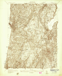 1932 White Plains1932 Print · USGSWestchester County's evolving landscape is captured here in the early thirties, showing the dense growth of the county seat alongside massive institutional estates. Genealogists and historians can locate families in White Plains or trace the early grounds of Marymount College and Sleepy Hollow Cemetery.
 - 1936 Map of West Point
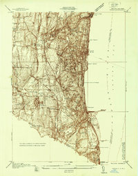
 1936 West Point1936 Print · USGSThe Hudson Highlands in the mid-1930s reveal a landscape of strategic military grounds and evolving state parks. Genealogists and historians can trace old family burial grounds like Halstead Cem, the workings of the Mahopac Mines, and the early layout of West Point.2 unique versions available
 - 1936 Map of Ossining
 1936 Ossining1936 Print · USGSWestchester County in the mid-thirties exhibits a landscape of growing suburban centers and massive public works. Genealogists and historians can trace the foundations of Briarcliff Manor and Pleasantville, alongside landmarks like Sing Sing State Prison and the Croton Dam.
 - 1937 Map of Nyack
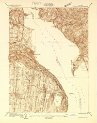
 1937 Nyack1937 Print · USGSRockland County’s riverfront and wooded interior are shown here in the late 1930s as the rail-and-river economy remained in full swing. Genealogists and historians can trace family locations near the Rockland State Hospital, Piermont, and the St Catharines Cem.
 - 1937 Map of Tarrytown
 1937 Tarrytown1937 Print · USGSThe Hudson River valley during the 1930s serves as a busy corridor of rail, water, and infrastructure. Genealogists and local historians can trace the old landings at Waldberg Landing, the grounds of the State Prison in Ossining, and the rail lines through Nyack.
 - 1938 Map of Haverstraw
 1938 Haverstraw1938 Print · USGSThe lower Hudson River corridor comes alive in this late 1930s survey of the bustling industrial and commuter towns along the riverbanks. Researchers can trace the path of the West Shore RR, find family roots at St Peters Cem, or locate the New York Reconstruction Home.
 - 1938 Map of White Plains
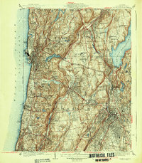 1938 White Plains1938 Print · USGSWestchester County in the late 1930s is a landscape of grand estates, institutional campuses, and thriving commuter rail towns. Researchers can trace family history through the Gate of Heaven Cemetery, locate historic sites like Kykuit, or study the grounds of Marymount College and the Bloomingdale Asylum.3 unique versions available
End of results
Showing maps 1-7 of 7
Top cities of Westchester County
- Yonkers historical maps
- Greenburgh historical maps
- New Rochelle historical maps
- Mount Vernon historical maps
- White Plains historical maps
- Rye historical maps
See more
Frequently asked questions
- What are the different types of historical maps available for Westchester County?
- What is the oldest map of Westchester County?
- Where can I purchase historical maps of Westchester County for my home or office?
- Where can I download high-res historical maps of Westchester County?
- Are there historical topographic maps available for Westchester County?
- Is there historical aerial imagery available for Westchester County?
- Where are historical maps of Westchester County sourced from?