1970s Maps of Alexander County, North Carolina
Explore 6 historic maps of Alexander County from the 1970s. These maps offer a rare glimpse into what life looked like during the 1970s — showing old roads, neighborhoods, homes, and landmarks that have changed or disappeared over time.
Whether you're researching your family's past, planning a metal detecting trip, or studying how Alexander County's landscape evolved across the 1970s, these high-resolution maps are a powerful tool for exploring the history of this region.
- Focus on a specific era: All maps on this page are from the 1970s, giving you a focused view of this time period.
- See what’s changed: Compare century-old streets, trails, and buildings to today's modern landscape using overlays and satellite layers.
- Research with precision: Use these maps for genealogy, historical research, land use analysis, or educational projects.
- View, download, or print: Maps are fully viewable online in high resolution, and can be downloaded or printed for your own records.
Start exploring Alexander County's history through authentic maps from the 1970s. This is your window into the past.
Alexander County, NC maps
(6)- 1970 Map of Hiddenite, 1972 Print
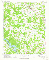
 1970 Hiddenite1972 Print · USGSAlexander County’s rolling hills and river valleys are captured here in the early 1970s, centered on the community of Hiddenite. Researchers can locate numerous rural landmarks including Linneys Grove Ch, the Quarry at Rocky Face, and the Zion Chapel Cem.
 - 1970 Map of Bethlehem, 1973 Print
 1970 Bethlehem1973 Print · USGSThe northern edge of Hickory and the waters of Lake Hickory come into sharp focus during this period of 1970s growth. Researchers can trace the development of lakeside communities like Bethlehem or locate family landmarks such as Isaac Creek Ch and Bentley Cem.
 - 1970 Map of Ellendale, 1973 Print
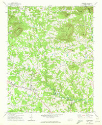
 1970 Ellendale1973 Print · USGSAlexander County is captured in the early 1970s, showcasing the traditional landscape of the Brushy Mountains before modern development. Genealogists and local historians can trace family locations near All Healing Springs, Oxford Memorial Ch, and Never Mtn.
 - 1970 Map of Stony Point, 1973 Print
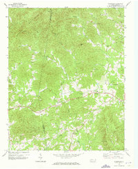
 1970 Stony Point1973 Print · USGSThe Alexander and Iredell County line comes alive in the early 1970s as the Alexander RR services rural rail stops. Local historians can trace the development of Lookout Shoals Lake and locate community hubs like Stony Point and Bunker Hill High Sch.2 unique versions available
 - 1970 Map of Millersville, 1973 Print
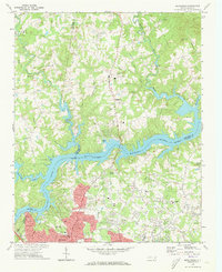
 1970 Millersville1973 Print · USGSIn the early 1970s, the Catawba River valley around the Alexander and Catawba county line saw a mix of industrial utility and new recreation. Local historians can trace family church sites like Bethel Ch and Oxford Ch alongside the industrial footprint of Oxford Dam.2 unique versions available
 - 1970 Map of Taylorsville, 1973 Print
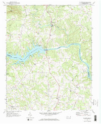
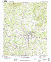 1970 Taylorsville1973 Print · USGSTaylorsville and its surrounding Alexander County foothills are captured here in the early seventies, just as the local infrastructure was modernizing. Genealogists and researchers can trace rural life through numerous landmarks like Sugarloaf School, Jolly Cemetery, and the Alexander railroad corridor.
End of results
Showing maps 1-6 of 6
Top cities of Alexander County
Frequently asked questions
- What are the different types of historical maps available for Alexander County?
- What is the oldest map of Alexander County?
- Where can I purchase historical maps of Alexander County for my home or office?
- Where can I download high-res historical maps of Alexander County?
- Are there historical topographic maps available for Alexander County?
- Is there historical aerial imagery available for Alexander County?
- Where are historical maps of Alexander County sourced from?