1960s Maps of Edgecombe County, North Carolina
Explore 5 historic maps of Edgecombe County from the 1960s. These maps offer a rare glimpse into what life looked like during the 1960s — showing old roads, neighborhoods, homes, and landmarks that have changed or disappeared over time.
Whether you're researching your family's past, planning a metal detecting trip, or studying how Edgecombe County's landscape evolved across the 1960s, these high-resolution maps are a powerful tool for exploring the history of this region.
- Focus on a specific era: All maps on this page are from the 1960s, giving you a focused view of this time period.
- See what’s changed: Compare century-old streets, trails, and buildings to today's modern landscape using overlays and satellite layers.
- Research with precision: Use these maps for genealogy, historical research, land use analysis, or educational projects.
- View, download, or print: Maps are fully viewable online in high resolution, and can be downloaded or printed for your own records.
Start exploring Edgecombe County's history through authentic maps from the 1960s. This is your window into the past.
Edgecombe County, NC maps
(5)- 1960 Map of Draughn, 1964 Print
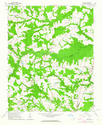
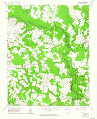 1960 Draughn1964 Print · USGSThe borderlands of Halifax and Edgecombe counties appear here in the early 1960s, a landscape defined by the winding course of Fishing Creek. Researchers can locate family landmarks like O'Neal Cem and local centers including Bethlehem Ch.
 - 1961 Map of Whitakers, 1964 Print
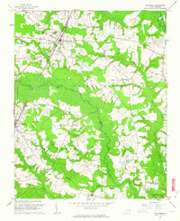 1961 Whitakers1964 Print · USGSCoastal Plain agriculture and rail travel define the Nash-Edgecombe borderlands during the early sixties. Researchers can trace family history through a network of small churches and crossroads like Jerusalem Ch, Speight Chapel, and Taylor Crossroads.2 unique versions available
 - 1961 Map of Enfield, 1964 Print
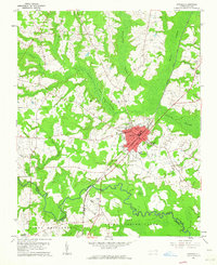 1961 Enfield1964 Print · USGSEnfield was a bustling railroad hub in the early 1960s, centered on the intersection of the Atlantic Coast Line and local routes. Genealogists can trace family names through landmarks like Pittman Cem and Overstreet Cem or locate the Inborden Sch and Bricks settlement.
 - 1962 Map of Hobgood, 1964 Print
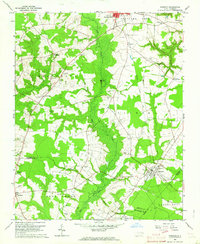 1962 Hobgood1964 Print · USGSThe rural landscape of Halifax and Edgecombe counties is captured here in the early sixties, centered on the railroad town of Hobgood. Researchers can trace old family sites and rural landmarks like the Leggett House Cem, Shield Sch, and Kehukee Ch.2 unique versions available
 - 1963 Map of Drake, 1964 Print
 1963 Drake1964 Print · USGSCoastal Plain farmland and swampy creek bottoms define this Nash County area in the early sixties. Genealogists can trace family names at Dozier Cem and Harper Cem or locate community hubs like Dortches, Drake, and North Carolina Wesleyan College.2 unique versions available
End of results
Showing maps 1-5 of 5
Top cities of Edgecombe County
- Tarboro historical maps
- Princeville historical maps
- Pinetops historical maps
- Macclesfield historical maps
- Conetoe historical maps
- Speed historical maps
See more
Frequently asked questions
- What are the different types of historical maps available for Edgecombe County?
- What is the oldest map of Edgecombe County?
- Where can I purchase historical maps of Edgecombe County for my home or office?
- Where can I download high-res historical maps of Edgecombe County?
- Are there historical topographic maps available for Edgecombe County?
- Is there historical aerial imagery available for Edgecombe County?
- Where are historical maps of Edgecombe County sourced from?