1980s Maps of Edgecombe County, North Carolina
Explore 11 historic maps of Edgecombe County from the 1980s. These maps offer a rare glimpse into what life looked like during the 1980s — showing old roads, neighborhoods, homes, and landmarks that have changed or disappeared over time.
Whether you're researching your family's past, planning a metal detecting trip, or studying how Edgecombe County's landscape evolved across the 1980s, these high-resolution maps are a powerful tool for exploring the history of this region.
- Focus on a specific era: All maps on this page are from the 1980s, giving you a focused view of this time period.
- See what’s changed: Compare century-old streets, trails, and buildings to today's modern landscape using overlays and satellite layers.
- Research with precision: Use these maps for genealogy, historical research, land use analysis, or educational projects.
- View, download, or print: Maps are fully viewable online in high resolution, and can be downloaded or printed for your own records.
Start exploring Edgecombe County's history through authentic maps from the 1980s. This is your window into the past.
Edgecombe County, NC maps
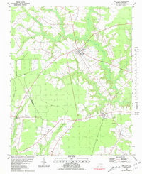
(11)- 1980 Map of Pinetops, 1981 Print
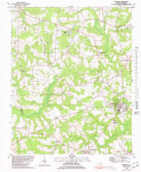 1980 Pinetops1981 Print · USGSEdgecombe County was a landscape of established rail towns and rural church communities in the late 1970s. Trace family roots and local history through landmarks like Temperance Hall, the streets of Pinetops, and centers of worship such as Morning Star Ch.
 - 1980 Map of Falkland, 1981 Print
 1980 Falkland1981 Print · USGSPitt County's rural landscape is captured here in the late seventies, centered on the river-bend settlement of Falkland. Researchers can trace old family sites and community centers like Sharp Point, Dupree Landing, and Kings Crossroads.2 unique versions available
 - 1981 Map of Speed
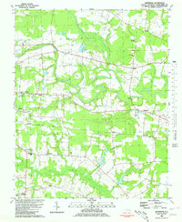
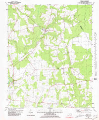 1981 Speed1981 Print · USGSEdgecombe County at the dawn of the eighties reveals a landscape of railroad towns and riverfront hamlets shaped by the Tar River. Genealogists can locate family landmarks such as White Chapel, Roberson Sch, and the rural community of Coakley.2 unique versions available
 - 1981 Map of Robersonsville West
 1981 Robersonsville West1981 Print · USGSCoastal plain settlements and railroad junctions define this 1980s landscape across the Pitt and Martin county lines. Genealogists and historians can trace family roots through numerous unnamed cemeteries and community hubs like Parmele, Hickory Grove Ch, and the Seaboard Coast Line tracks.
 - 1981 Map of Conetoe
 1981 Conetoe1981 Print · USGSCoastal plain settlements and expansive wetlands define this region in the early eighties. Genealogists and local historians can trace family-named crossroads like Mayos Crossroads, find country sites like Johnson Ch, and follow the Seaboard Coast Line through Conetoe.
 - 1981 Map of Oak City
 1981 Oak City1981 Print · USGSIn the early 1980s, this area of Martin County was defined by its railroad hamlets and extensive swamp drainage systems. Researchers can locate many rural landmarks including Merritts Chapel, the Lookout Tower, and cemeteries near Hassell and Oak City.
 - 1981 Map of Hartsease
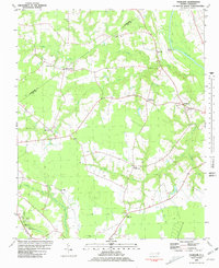
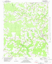
 1981 Hartsease1981 Print · USGSEdgecombe County in the early eighties is defined by the winding Tar River and the rural communities it supports. Researchers can trace family roots at Old Town Cem or explore established settlements like Kingsboro and Bullucks Crossroads.2 unique versions available
 - 1981 Map of Fountain, 1982 Print
 1981 Fountain1982 Print · USGSCoastal plain agriculture and small-town life in the early eighties center on the rural crossroads of Pitt and Edgecombe counties. Trace the roots of local communities at Piney Grove Sch, an Old Railroad Grade, and Webbtown Ch.
 - 1981 Map of Tarboro, 1982 Print
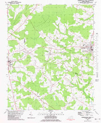
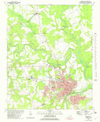 1981 Tarboro1982 Print · USGSEdgecombe County in the early eighties shows the historic river towns of Tarboro and Princeville during a period of modern expansion. Genealogists can trace family landmarks like Penders Chapel, Old Salem Ch, and the County Home Cem across this lowland landscape.2 unique versions available
 - 1985 Map of Rocky Mount
 1985 Rocky Mount1985 Print · USGSThe eastern North Carolina coastal plain in the mid-eighties shows a landscape defined by its river-and-rail heritage. Genealogists and local historians can trace the development of Rocky Mount, Greenville, and Wilson, or locate landmarks like East Carolina University and the Voice of America site.2 unique versions available
 - 1985 Map of Roanoke Rapids
 1985 Roanoke Rapids1985 Print · USGSNorthern North Carolina's river-driven economy is on display here in the mid-1980s, from the hydro-power at Roanoke Rapids to the rural millponds. Genealogists can trace family lands near Wiccacanee Pond, Mush Island, or the remote Urahaw Swamp.2 unique versions available
End of results
Showing maps 1-11 of 11
Top cities of Edgecombe County
- Tarboro historical maps
- Princeville historical maps
- Pinetops historical maps
- Macclesfield historical maps
- Conetoe historical maps
- Speed historical maps
See more
Frequently asked questions
- What are the different types of historical maps available for Edgecombe County?
- What is the oldest map of Edgecombe County?
- Where can I purchase historical maps of Edgecombe County for my home or office?
- Where can I download high-res historical maps of Edgecombe County?
- Are there historical topographic maps available for Edgecombe County?
- Is there historical aerial imagery available for Edgecombe County?
- Where are historical maps of Edgecombe County sourced from?