1930s Maps of Haywood County, North Carolina
Explore 19 historic maps of Haywood County from the 1930s. These maps offer a rare glimpse into what life looked like during the 1930s — showing old roads, neighborhoods, homes, and landmarks that have changed or disappeared over time.
Whether you're researching your family's past, planning a metal detecting trip, or studying how Haywood County's landscape evolved across the 1930s, these high-resolution maps are a powerful tool for exploring the history of this region.
- Focus on a specific era: All maps on this page are from the 1930s, giving you a focused view of this time period.
- See what’s changed: Compare century-old streets, trails, and buildings to today's modern landscape using overlays and satellite layers.
- Research with precision: Use these maps for genealogy, historical research, land use analysis, or educational projects.
- View, download, or print: Maps are fully viewable online in high resolution, and can be downloaded or printed for your own records.
Start exploring Haywood County's history through authentic maps from the 1930s. This is your window into the past.
Haywood County, NC maps
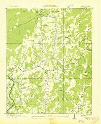
(19)- 1935 Map of Cruso
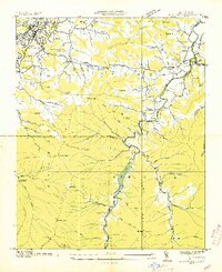
 1935 Cruso1935 Print · USGSHigh in the Blue Ridge during the mid-thirties, the East Fork Pigeon River valley reveals a landscape of isolated mountain settlements and forest. Genealogists and hikers can trace old homesteads near Cruso, locate the Quinn Cem, and follow the original path of State Highway No 284.
 - 1935 Map of Newport
 1935 Newport1935 Print · USGSIn the mid-1930s, this area of East Tennessee was a landscape of river-valley towns and mountain communities. Genealogists and historians can trace family locations through numerous rural landmarks like Rosenwald Sch, Jenkins Mill, and Bethel Ch.
 - 1935 Map of Waynesville
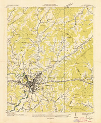
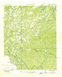
 1935 Waynesville1935 Print · USGSWaynesville and the surrounding Haywood County peaks are captured here in the mid-1930s as the regional economy balanced town industry with upland farming. Researchers can trace families near Greenhill Cem, locate the Cecil Sch, and follow the old routes of State Highway No 10.
 - 1935 Map of Hartford
 1935 Hartford1935 Print · USGSCocke County’s river valleys and mountain peaks are captured here in the mid-1930s as the national park took shape. Researchers can trace the river-economy through HARTFORD and Naillon Sta or locate family sites like Padgett Mill and Catons Grove.
 - 1935 Map of Canton
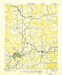
 1935 Canton1935 Print · USGSCanton and the surrounding Blue Ridge foothills are captured in detail during the mid-1930s as the railroad and river economy flourished. Genealogists can locate family landmarks like Roberson School, Piney Grove Church, and the settlement at Turnpike.
 - 1935 Map of Sam Knob
 1935 Sam Knob1935 Print · USGSThe high peaks of the Blue Ridge are captured in the mid-1930s just as the New Deal transformed the forest. Trace early landmarks like CCC Camp NC F 25 and Charley Creek Sch, or locate natural features like Devils Court House and Sam Knob.
 - 1935 Map of Dellwood
 1935 Dellwood1935 Print · USGSHaywood County in the mid-1930s is a landscape of high mountain coves and valley settlements at the edge of the Smokies. Genealogists can trace early family sites at Yarbrough Cem and Suttontown Sch or locate the community at Maggie.
 - 1935 Map of Tuckaseigee
 1935 Tuckaseigee1935 Print · USGSJackson County's high mountain valleys are captured here in the mid-1930s as the Tuckaseigee River area underwent early TVA-era surveying. Genealogists can trace local roots through landmarks like Caney Fork Sch, Sols Creek Ch, and the settlement at Cowarts.
 - 1935 Map of Clyde
 1935 Clyde1935 Print · USGSThe Pigeon River valley comes into focus in the mid-1930s, showing the early development of Clyde and Waynesville. Genealogists can trace family names at Medford Cem or locate remote landmarks like the Chambers Fire Tower and Hyder Mtn Sch.
 - 1935 Map of Hazelwood
 1935 Hazelwood1935 Print · USGSHaywood and Jackson counties meet along these high ridgelines during the mid-1930s, where the Southern railway climbs toward the clouds. Researchers can locate early family landmarks like Plott Cem, the Allen Creek Sch, and high-altitude settlements at Balsam and Clarks Siding.
 - 1935 Map of Shining Rock
 1935 Shining Rock1935 Print · USGSThe high country of Transylvania and Haywood counties is mapped here in the mid-1930s as federal conservation efforts took hold. Researchers can trace the early footprint of CCC Camp F 1 and locate landmarks like Silvermine and Lookingglass Rock.
 - 1935 Map of Addie
 1935 Addie1935 Print · USGSThe Balsam Mountains and the Qualla Indian Reservation define this Jackson County landscape in the mid-thirties. Family historians can trace the Southern RR line to find rural community hubs like Beta, Scott Creek Sch, and Buff Creek Ch.
 - 1935 Map of Lemon Gap
 1935 Lemon Gap1935 Print · USGSThe high ridges of the Madison County borderlands are shown in the mid-1930s as a network of gap settlements and mountain schools. Genealogists and hikers can trace the Appalachian Trail past early landmarks like the Joe PO. and Ebbs Mill.
 - 1936 Map of Sandymush
 1936 Sandymush1936 Print · USGSBuncombe and Madison Counties are captured in the mid-1930s as high-country communities transitioned toward modern road systems. Researchers can trace family roots through numerous mountain houses and rural landmarks like Sandymush Brick Ch, Gentrys Mill, and Lusk Chapel.
 - 1936 Map of Bunches Bald
 1936 Bunches Bald1936 Print · USGSThe high ridges and tribal lands of Swain and Jackson counties are documented here in the mid-1930s as the national park system was taking shape. Genealogists and hikers can trace the Bunches Trail, locate the Peach Tree Ch, and study the early layout of the Cherokee Indian Reservation.
 - 1936 Map of Hepco
 1936 Hepco1936 Print · USGSHaywood and Madison counties are captured here in the mid-1930s, showing a landscape of high ridges and rural valley communities. Genealogists can trace family roots through landmarks like James Chapel Sch, Belmont Ch, and the settlement of Hepco near the Hepco Dam.
 - 1936 Map of Cove Creek Gap
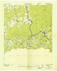
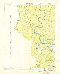 1936 Cove Creek Gap1936 Print · USGSHaywood County is captured in the mid-1930s as the Tennessee Valley Authority transformed the river valleys. Researchers can locate vanished rural schools and family cemeteries such as Big Bend Sch, Clark Cem, and the church at Pigeon Ch.
 - 1936 Map of Waterville
 1936 Waterville1936 Print · USGSThe Tennessee and North Carolina borderlands are captured here in the mid-1930s as hydropower and conservation efforts reshaped the mountains. Researchers can trace early industry and family history through the Power Plant at Waterville, the Appalachian Trail, and community sites like Cogdill Chapel.
 - 1936 Map of Dunsmore Mountain
 1936 Dunsmore Mountain1936 Print · USGSThe Pisgah National Forest region comes alive in the mid-1930s, showing a landscape of remote mountain churches and early forest management. Genealogists can trace family landmarks like Kelly Cem, Stony Fork Sch, and the high-elevation Buck Spring Lodge.
End of results
Showing maps 1-19 of 19
Top cities of Haywood County
Frequently asked questions
- What are the different types of historical maps available for Haywood County?
- What is the oldest map of Haywood County?
- Where can I purchase historical maps of Haywood County for my home or office?
- Where can I download high-res historical maps of Haywood County?
- Are there historical topographic maps available for Haywood County?
- Is there historical aerial imagery available for Haywood County?
- Where are historical maps of Haywood County sourced from?