1940s Maps of Haywood County, North Carolina
Explore 28 historic maps of Haywood County from the 1940s. These maps offer a rare glimpse into what life looked like during the 1940s — showing old roads, neighborhoods, homes, and landmarks that have changed or disappeared over time.
Whether you're researching your family's past, planning a metal detecting trip, or studying how Haywood County's landscape evolved across the 1940s, these high-resolution maps are a powerful tool for exploring the history of this region.
- Focus on a specific era: All maps on this page are from the 1940s, giving you a focused view of this time period.
- See what’s changed: Compare century-old streets, trails, and buildings to today's modern landscape using overlays and satellite layers.
- Research with precision: Use these maps for genealogy, historical research, land use analysis, or educational projects.
- View, download, or print: Maps are fully viewable online in high resolution, and can be downloaded or printed for your own records.
Start exploring Haywood County's history through authentic maps from the 1940s. This is your window into the past.
Haywood County, NC maps
(28)- 1940 Map of Hartford
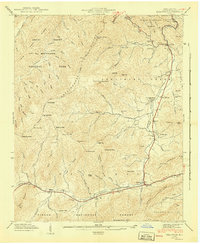
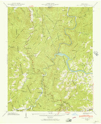
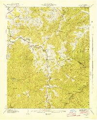
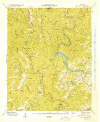
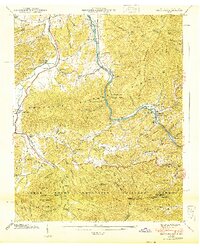 1940 Hartford1940 Print · USGSThe Pigeon River valley comes to life in this 1940s survey of the Tennessee and North Carolina border. Genealogists can locate family names at Shultz Cem and Mcmillan Cem or trace the original route of the Appalachian Trail.6 unique versions available
 - 1940 Map of Waterville
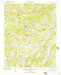
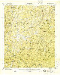 1940 Waterville1940 Print · USGSThe Tennessee and North Carolina borderlands come into focus in the 1940s, where three major national forests and parks converge. Genealogists and historians can trace high-country family sites like Ball Cem, Andrews Chapel, and the isolated Waterville Sch.6 unique versions available
 - 1940 Map of Lemon Gap
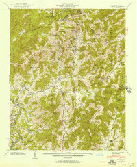
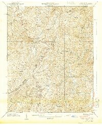 1940 Lemon Gap1940 Print · USGSThe Tennessee and North Carolina borderlands come into focus in the 1940s, showing the high ridges of the Bald Mountains and the Appalachian Trail. Genealogists and hikers can trace old mountain routes like the Jack Trail to family sites including Joe (PO), Ebbs Mill, and Balding Chapel.5 unique versions available
 - 1941 Map of Addie
 1941 Addie1941 Print · USGSJackson County's mountain settlements and rail corridors are captured here just before the mid-century, centered on the Southern railroad route. Researchers can trace family sites like Norman Cem or locate community centers at Liberty Sch and Ochre Hill Ch.2 unique versions available
 - 1941 Map of Dellwood
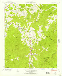
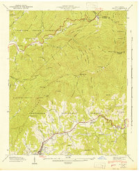
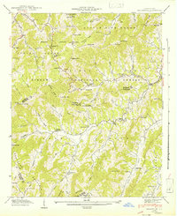
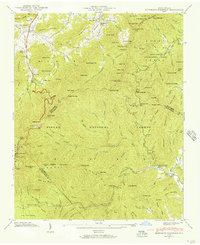
 1941 Dellwood1941 Print · USGSHaywood County’s high valleys appear here in the early 1940s, showing a landscape of small creek-side settlements and national forest boundaries. Researchers can locate family landmarks like Howell Cem, rural institutions such as Rock Hill Sch, and the scattered homes of Suttontown.7 unique versions available
 - 1941 Map of Clyde, 1956 Print
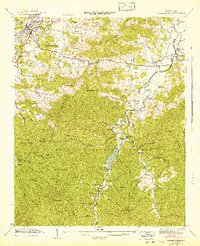
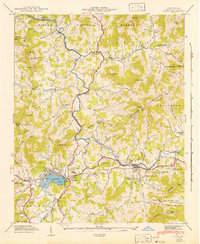
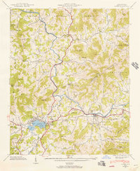 1941 Clyde1956 Print · USGSHaywood County is seen here in the early 1940s, where the Pigeon River and SOUTHERN railroad shaped the local valley economies. Researchers can trace family sites from Lake Junaluska to rural landmarks like Antioch Ch and Bonaventure Cem.
 - 1941 Map of Canton, 1956 Print
 1941 Canton1956 Print · USGSMid-century Haywood County reveals a landscape where the industrial activity of Canton meets the steep coves of the Pisgah National Forest. Genealogists and local historians can trace rural family landmarks like the Clark Cem, Henderson Cem, and Oak Grove Ch.
 - 1941 Map of Waynesville, 1956 Print
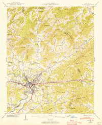
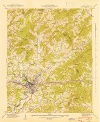
 1941 Waynesville1956 Print · USGSWaynesville and the surrounding Blue Ridge coves are captured here in the early 1940s as the regional economy balanced valley industry with mountain resources. Genealogists and hikers can trace family sites like Ratcliff Cove Ch, the Big Ridge Mine, and Lake Logan.3 unique versions available
 - 1941 Map of Cove Creek Gap, 1956 Print
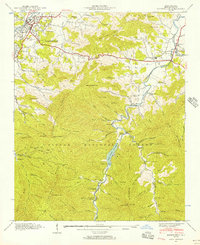
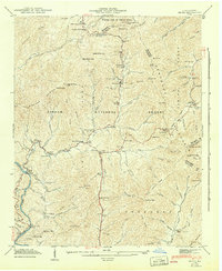
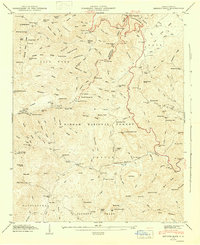
 1941 Cove Creek Gap1956 Print · USGSHaywood County is shown in the early forties during the expansion of the national park system into the mountains. Genealogists can trace family footprints at Little Cataloochee Ch, the Beech Grove Sch, and cemeteries like Hannah Cem or Redman Cem.
 - 1941 Map of Hazelwood, 1957 Print
 1941 Hazelwood1957 Print · USGSThe high passes of the Plott Balsams were a vital rail and road corridor in the early 1940s. Genealogists and historians can trace the foundations of Hazelwood and Balsam, finding remote sites like the Grassy Ridge Mine and Redbank Cem.7 unique versions available
 - 1941 Map of Sandymush, 1957 Print
 1941 Sandymush1957 Print · USGSThe high ridges and deep coves of the Blue Ridge come alive in this early 1940s survey of the Madison and Buncombe county lines. Local historians can trace family-named gaps and rural congregations like Little Sandymush Ch, Ebenezer Ch, and the remote settlement of Luck.3 unique versions available
 - 1941 Map of Hepco, 1957 Print
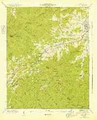
 1941 Hepco1957 Print · USGSWestern North Carolina's high country during the early 1940s shows a landscape of isolated mountain coves and tight-knit communities. Researchers can locate the early centers of local life at Fines Creek Ch, the settlement of Hepco, and the high ridges of Sandymush Bald.
 - 1941 Map of Cruso, 1957 Print
 1941 Cruso1957 Print · USGSThe high ridges of Haywood County meet the Buncombe line in the 1940s, showing the mountain coves of the Pisgah National Forest. Genealogists can trace early homesteads and landmarks like Quinn Cem, Springdale Sch, and Meadow Grove Ch.6 unique versions available
 - 1942 Map of Cruso
 1942 Cruso1942 Print · USGSHaywood County is shown in the early 1940s as a high-mountain landscape of scattered cove settlements and national forest land. Researchers can locate family landmarks such as Quinn Cem, Mt Zion Ch, and the high-altitude Lookout Tower near Fryingpan Mountain.
 - 1942 Map of Waynesville
 1942 Waynesville1942 Print · USGSWaynesville and the high peaks of the Blue Ridge are captured here in the early 1940s as the regional timber and mountain economy matured. Genealogists can locate family landmarks like Elizabeth Chapel, Greenhill Cem, and the rural Cecil Sch.2 unique versions available
 - 1942 Map of Addie
 1942 Addie1942 Print · USGSJackson County's mountain communities and the Southern railroad corridor are captured here in the early 1940s. Researchers can locate family landmarks like Norman Cem or trace the early development of Sylva, Addie, and Willits.
 - 1942 Map of Hazelwood
 1942 Hazelwood1942 Print · USGSThe mountain communities around WAYNESVILLE and Hazelwood are shown just before the mid-century during this era of rail travel and early industry. Trace family sites at the Allen Creek Sch or search for local landmarks like the Grassy Ridge Mine and Redbank Cem.
 - 1942 Map of Sandymush
 1942 Sandymush1942 Print · USGSThe high ridges of Madison and Buncombe counties come alive in this early 1940s survey, showing mountain life within the Pisgah National Forest. Genealogists can trace family roots at remote landmarks like Lusk Chapel, Chestnut Grove Ch, and Jones Valley Ch.
 - 1942 Map of Hepco
 1942 Hepco1942 Print · USGSNorth Carolina's high mountain hollows are documented here during the early 1940s, showing the intersection of three counties and the Pisgah National Forest. Genealogists can locate community centers like Fines Creek Sch, James Chapel, and the isolated Pine Grove Cem.2 unique versions available
 - 1942 Map of Clyde
 1942 Clyde1942 Print · USGSHaywood County at the start of the 1940s reveals a landscape of tight-knit cove communities and river-valley industry. Genealogists and historians can trace family locations through Lake Junaluska, Old Thickety Ch, and the many coves like Heines Cove.
 - 1942 Map of Canton
 1942 Canton1942 Print · USGSCanton and the Pigeon River valley are captured here during the early 1940s, showing the industrial core of Fiberville and the surrounding rural communities. Genealogists can locate family landmarks like Henderson Cem, Browns Chapel, and Beaverdam Sch.2 unique versions available
 - 1942 Map of Cove Creek Gap
 1942 Cove Creek Gap1942 Print · USGSThe North Carolina mountains are shown just as the national park and forest boundaries were being established in the 1940s. Genealogists can locate family landmarks like Palmer Chapel, Beech Grove Sch, and numerous mountain burial grounds like Hannah Cem.
 - 1942 Map of Dunsmore Mountain, 1957 Print
 1942 Dunsmore Mountain1957 Print · USGSThe high peaks and deep coves of the Pisgah National Forest are meticulously mapped here in the early 1940s. Genealogists and local historians can locate early landmarks such as Buck Spring Lodge, the Kelly Cem, and Pisgah Ch.2 unique versions available
 - 1943 Map of Dunsmore Mountain
 1943 Dunsmore Mountain1943 Print · USGSThe high peaks of the Blue Ridge were a focus of federal forest management and early recreation during the early 1940s. Genealogists and hikers can trace the geography of Buck Spring Lodge, The Pink Beds, and the Kelly Cem.
 - 1946 Map of Shining Rock, 1947 Print
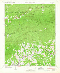
 1946 Shining Rock1947 Print · USGSThe North Carolina high country is captured here just after the war as the Blue Ridge Parkway begins to reshape the region. Researchers can trace the early layout of the Fish Rearing Station or locate landmarks like Looking Glass Rock and Picklesimer Fields.7 unique versions available
Showing maps 1-25 of 28
Top cities of Haywood County
Frequently asked questions
- What are the different types of historical maps available for Haywood County?
- What is the oldest map of Haywood County?
- Where can I purchase historical maps of Haywood County for my home or office?
- Where can I download high-res historical maps of Haywood County?
- Are there historical topographic maps available for Haywood County?
- Is there historical aerial imagery available for Haywood County?
- Where are historical maps of Haywood County sourced from?