Old Maps of Haywood County, North Carolina for Metal Detecting
Plan your next treasure hunt with 184 historic maps of Haywood County. Find old homesites, ghost towns, trails, and gathering spots that may be lost to time — perfect for identifying promising metal detecting locations.
- Locate forgotten sites: Uncover places like long-lost settlements, abandoned rail lines, or gathering spots.
- Plan better hunts: Use map overlays combined with LiDAR or satellite views to narrow in on historically rich areas.
- Made for detectorists: Thousands of hobbyists use these maps to discover relics, coins, and hidden history.
Use these historic maps to boost your research and find new opportunities beneath the surface of Haywood County.
Haywood County, NC maps
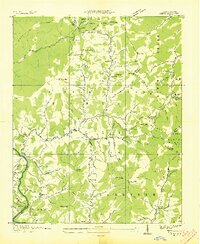
(184)- 1891 Map of Cowee
 1891 Cowee1891 Print · USGSWestern North Carolina's high mountain reaches are captured here in the late nineteenth century as the railroad began to transform the region. Trace early transport routes like the Western North Carolina Railroad and Cowee Tunnel alongside old settlements at Franklin and Quallatown.
 - 1893 Map of Mt Guyot
 1893 Mt Guyot1893 Print · USGSThe Tennessee and North Carolina borderlands are captured here in the 1890s, when isolated mountain coves and river towns relied on the Virginia and Georgia Railroad. Researchers can trace old family sites and transport routes through Fair Garden, Jones Cove, and along the Elliot Ferry Road.3 unique versions available
 - 1894 Map of Asheville
 1894 Asheville1894 Print · USGSAsheville and the French Broad River valley are shown here in the 1890s, when rail travel was transforming the Southern Appalachians. Genealogists can locate family landmarks like Gudgers Mill, Pendletons Mill, and the early development of Biltmore.2 unique versions available
 - 1897 Map of Cowee
 1897 Cowee1897 Print · USGSThe Great Smoky Mountains and Blue Ridge foothills appear here in the 1890s, when the railroad first began to penetrate the high gaps. Trace family roots and mountain industry through old settlements like Quallatown, Sylva, and the Cowee Tunnel engineering site.4 unique versions available
 - 1901 Map of Asheville
 1901 Asheville1901 Print · USGSWestern North Carolina at the turn of the century shows a mountain landscape adapting to the arrival of major railroads. Genealogists and historians can trace family-named peaks and early communities like Mars Hill, Hot Springs, and the estates at Biltmore.9 unique versions available
 - 1905 Map of Pisgah, 1956 Print
 1905 Pisgah1956 Print · USGSThe North Carolina high country around the turn of the century reveals a land of timber tracts and emerging mountain retreats. Genealogists and hikers can trace early routes to Buck Spring Lodge, follow the Southern RR tracks, and locate vanished settlements like Angeline and Calhoun.
 - 1906 Map of Pisgah, 1934 Print
 1906 Pisgah1934 Print · USGSThe Blue Ridge highlands at the turn of the century reveal a landscape of mountain river valleys and early timber frontiers. Genealogists and historians can trace family-named bridges and crossings like Graham Bridge or locate vanished settlements such as Grange and Retreat.2 unique versions available
 - 1907 Map of Cowee
 1907 Cowee1907 Print · USGSWestern North Carolina at the turn of the century shows a landscape of rail-connected river towns and high mountain gaps. Genealogists can trace early homesteads and industry through landmarks like West Mill, Roanes Mill, and the many settlements along the Southern Railway.5 unique versions available
 - 1912 Map of Mt Guyot
 1912 Mt Guyot1912 Print · USGSThe Tennessee and North Carolina borderlands come into focus in the early twentieth century, prior to the creation of the Great Smoky Mountains National Park. Trace ancestral locations like Cataloochee and Smokemont or follow the Southern RR to Newport.5 unique versions available
 - 1935 Map of Cruso
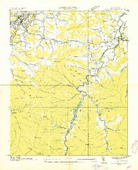
 1935 Cruso1935 Print · USGSHigh in the Blue Ridge during the mid-thirties, the East Fork Pigeon River valley reveals a landscape of isolated mountain settlements and forest. Genealogists and hikers can trace old homesteads near Cruso, locate the Quinn Cem, and follow the original path of State Highway No 284.
 - 1935 Map of Newport
 1935 Newport1935 Print · USGSIn the mid-1930s, this area of East Tennessee was a landscape of river-valley towns and mountain communities. Genealogists and historians can trace family locations through numerous rural landmarks like Rosenwald Sch, Jenkins Mill, and Bethel Ch.
 - 1935 Map of Waynesville
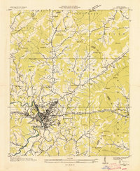
 1935 Waynesville1935 Print · USGSWaynesville and the surrounding Haywood County peaks are captured here in the mid-1930s as the regional economy balanced town industry with upland farming. Researchers can trace families near Greenhill Cem, locate the Cecil Sch, and follow the old routes of State Highway No 10.
 - 1935 Map of Hartford
 1935 Hartford1935 Print · USGSCocke County’s river valleys and mountain peaks are captured here in the mid-1930s as the national park took shape. Researchers can trace the river-economy through HARTFORD and Naillon Sta or locate family sites like Padgett Mill and Catons Grove.
 - 1935 Map of Canton
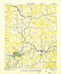
 1935 Canton1935 Print · USGSCanton and the surrounding Blue Ridge foothills are captured in detail during the mid-1930s as the railroad and river economy flourished. Genealogists can locate family landmarks like Roberson School, Piney Grove Church, and the settlement at Turnpike.
 - 1935 Map of Sam Knob
 1935 Sam Knob1935 Print · USGSThe high peaks of the Blue Ridge are captured in the mid-1930s just as the New Deal transformed the forest. Trace early landmarks like CCC Camp NC F 25 and Charley Creek Sch, or locate natural features like Devils Court House and Sam Knob.
 - 1935 Map of Dellwood
 1935 Dellwood1935 Print · USGSHaywood County in the mid-1930s is a landscape of high mountain coves and valley settlements at the edge of the Smokies. Genealogists can trace early family sites at Yarbrough Cem and Suttontown Sch or locate the community at Maggie.
 - 1935 Map of Tuckaseigee
 1935 Tuckaseigee1935 Print · USGSJackson County's high mountain valleys are captured here in the mid-1930s as the Tuckaseigee River area underwent early TVA-era surveying. Genealogists can trace local roots through landmarks like Caney Fork Sch, Sols Creek Ch, and the settlement at Cowarts.
 - 1935 Map of Clyde
 1935 Clyde1935 Print · USGSThe Pigeon River valley comes into focus in the mid-1930s, showing the early development of Clyde and Waynesville. Genealogists can trace family names at Medford Cem or locate remote landmarks like the Chambers Fire Tower and Hyder Mtn Sch.
 - 1935 Map of Hazelwood
 1935 Hazelwood1935 Print · USGSHaywood and Jackson counties meet along these high ridgelines during the mid-1930s, where the Southern railway climbs toward the clouds. Researchers can locate early family landmarks like Plott Cem, the Allen Creek Sch, and high-altitude settlements at Balsam and Clarks Siding.
 - 1935 Map of Shining Rock
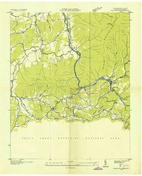
 1935 Shining Rock1935 Print · USGSThe high country of Transylvania and Haywood counties is mapped here in the mid-1930s as federal conservation efforts took hold. Researchers can trace the early footprint of CCC Camp F 1 and locate landmarks like Silvermine and Lookingglass Rock.
 - 1935 Map of Addie
 1935 Addie1935 Print · USGSThe Balsam Mountains and the Qualla Indian Reservation define this Jackson County landscape in the mid-thirties. Family historians can trace the Southern RR line to find rural community hubs like Beta, Scott Creek Sch, and Buff Creek Ch.
 - 1935 Map of Lemon Gap
 1935 Lemon Gap1935 Print · USGSThe high ridges of the Madison County borderlands are shown in the mid-1930s as a network of gap settlements and mountain schools. Genealogists and hikers can trace the Appalachian Trail past early landmarks like the Joe PO. and Ebbs Mill.
 - 1936 Map of Sandymush
 1936 Sandymush1936 Print · USGSBuncombe and Madison Counties are captured in the mid-1930s as high-country communities transitioned toward modern road systems. Researchers can trace family roots through numerous mountain houses and rural landmarks like Sandymush Brick Ch, Gentrys Mill, and Lusk Chapel.
 - 1936 Map of Bunches Bald
 1936 Bunches Bald1936 Print · USGSThe high ridges and tribal lands of Swain and Jackson counties are documented here in the mid-1930s as the national park system was taking shape. Genealogists and hikers can trace the Bunches Trail, locate the Peach Tree Ch, and study the early layout of the Cherokee Indian Reservation.
 - 1936 Map of Hepco
 1936 Hepco1936 Print · USGSHaywood and Madison counties are captured here in the mid-1930s, showing a landscape of high ridges and rural valley communities. Genealogists can trace family roots through landmarks like James Chapel Sch, Belmont Ch, and the settlement of Hepco near the Hepco Dam.
Showing maps 1-25 of 184
Top cities of Haywood County
Frequently asked questions
- What are the different types of historical maps available for Haywood County?
- What is the oldest map of Haywood County?
- Where can I purchase historical maps of Haywood County for my home or office?
- Where can I download high-res historical maps of Haywood County?
- Are there historical topographic maps available for Haywood County?
- Is there historical aerial imagery available for Haywood County?
- Where are historical maps of Haywood County sourced from?