1930s Maps of Mountain Home, North Carolina
Explore 4 historic maps of Mountain Home from the 1930s. These maps offer a rare glimpse into what life looked like during the 1930s — showing old roads, neighborhoods, homes, and landmarks that have changed or disappeared over time.
Whether you're researching your family's past, planning a metal detecting trip, or studying how Mountain Home's landscape evolved across the 1930s, these high-resolution maps are a powerful tool for exploring the history of this region.
- Focus on a specific era: All maps on this page are from the 1930s, giving you a focused view of this time period.
- See what’s changed: Compare century-old streets, trails, and buildings to today's modern landscape using overlays and satellite layers.
- Research with precision: Use these maps for genealogy, historical research, land use analysis, or educational projects.
- View, download, or print: Maps are fully viewable online in high resolution, and can be downloaded or printed for your own records.
Start exploring Mountain Home's history through authentic maps from the 1930s. This is your window into the past.
Mountain Home, NC maps
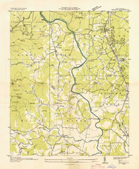
(4)- 1935 Map of Horse Shoe
 1935 Horse Shoe1935 Print · USGSWestern North Carolina's river valleys and mountain ridges are documented here in the mid-1930s as the Southern Railroad winds along the French Broad River. Researchers can trace old family sites and rural infrastructure including Prison Camp No 511, Oakdale Cem, and the historic Sewell House.
 - 1935 Map of Hendersonville
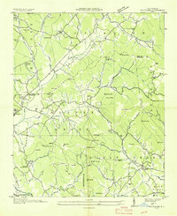
 1935 Hendersonville1935 Print · USGSHenderson County is captured in the mid-1930s as a bustling crossroads of rail transit and mountain agriculture. Genealogists and historians can trace the foundations of Hendersonville along the Southern Railway, locating the Military Academy, the Orphanage, and old family burial sites like Jones Cem.
 - 1936 Map of Skyland
 1936 Skyland1936 Print · USGSWestern North Carolina during the mid-thirties reveals a landscape of high ridges and developing river valleys. Genealogists and historians can trace local community roots through landmarks like Arden School, CCC Camp No 5, and Brickton Ch.
 - 1936 Map of Fruitland
 1936 Fruitland1936 Print · USGSThe Blue Ridge foothills of Henderson and Buncombe Counties come alive in the mid-1930s. Genealogists can trace family roots through the Fruitland Institute, Mountain Sanitarium, and rural sites like Tweed Chapel or Patty Chapel.
End of results
Showing maps 1-4 of 4
Top cities near Mountain Home
- Asheville historical maps
- Hendersonville historical maps
- Black Mountain historical maps
- Fletcher historical maps
- Brevard historical maps
- Mills River historical maps
See more
Top neighborhoods of Mountain Home
Frequently asked questions
- What are the different types of historical maps available for Mountain Home?
- What is the oldest map of Mountain Home?
- Where can I purchase historical maps of Mountain Home for my home or office?
- Where can I download high-res historical maps of Mountain Home?
- Are there historical topographic maps available for Mountain Home?
- Is there historical aerial imagery available for Mountain Home?
- Where are historical maps of Mountain Home sourced from?