1990s Maps of Hertford County, North Carolina
Explore 6 historic maps of Hertford County from the 1990s. These maps offer a rare glimpse into what life looked like during the 1990s — showing old roads, neighborhoods, homes, and landmarks that have changed or disappeared over time.
Whether you're researching your family's past, planning a metal detecting trip, or studying how Hertford County's landscape evolved across the 1990s, these high-resolution maps are a powerful tool for exploring the history of this region.
- Focus on a specific era: All maps on this page are from the 1990s, giving you a focused view of this time period.
- See what’s changed: Compare century-old streets, trails, and buildings to today's modern landscape using overlays and satellite layers.
- Research with precision: Use these maps for genealogy, historical research, land use analysis, or educational projects.
- View, download, or print: Maps are fully viewable online in high resolution, and can be downloaded or printed for your own records.
Start exploring Hertford County's history through authentic maps from the 1990s. This is your window into the past.
Hertford County, NC maps
(6)- 1990 Map of Emporia
 1990 Emporia1990 Print · USGSThe Southside Virginia borderlands are captured here in the late twentieth century, showing the critical rail and river networks of the region. Genealogists and local historians can trace family roots through rural communities like Alberta, Boykins, and Dolphin along the Meherrin River.
 - 1997 Map of Kelford, 2000 Print
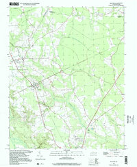 1997 Kelford2000 Print · USGSThe interconnected communities of Bertie County appear here in the late twentieth century, showing a landscape defined by agriculture and winding swamp systems. Researchers can locate local landmarks like the Peanut Belt Research Station, Beautiful Zion Ch, and the Roxobel-Kelford Cem.
 - 1997 Map of Boykins, 2000 Print
 1997 Boykins2000 Print · USGSThe Virginia and North Carolina borderlands come into focus in the late nineties as a landscape of river bends and rail towns. Trace local roots at Beechwood Cem or locate rural landmarks like Galilee Ch and Meherrin Sch.
 - 1997 Map of Valhalla, 2000 Print
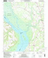
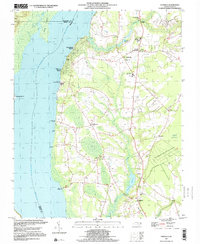 1997 Valhalla2000 Print · USGSThe Chowan River shoreline and the swampy interiors of Chowan County are captured here in the late nineties. Local researchers can trace family roots through numerous sites like Chowan Academy, Rockyhock Ch, and the many rural cemeteries scattered near Valhalla.
 - 1997 Map of Sunbeam, 2000 Print
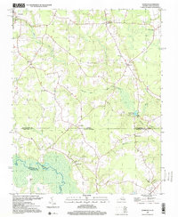 1997 Sunbeam2000 Print · USGSThe Virginia and North Carolina state line runs through this late-century rural landscape, where small crossroads communities and millponds define the border country. Researchers can trace family sites at Hollywood Cem or follow old routes through Sunbeam and Statesville.
 - 1997 Map of Mintonsville, 2000 Print
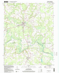
 1997 Mintonsville2000 Print · USGSThe Chowan River lowlands come to life in this survey from the late nineties, capturing the rural communities of Gates County before modern development. Genealogists can trace family roots through Mintonsville, Hutson Corner, and old landmarks like Cannon Ferry and Welchs Chapel.
End of results
Showing maps 1-6 of 6
Top cities of Hertford County
- Ahoskie historical maps
- Murfreesboro historical maps
- Winton historical maps
- Cofield historical maps
- Harrellsville historical maps
- Como historical maps
Frequently asked questions
- What are the different types of historical maps available for Hertford County?
- What is the oldest map of Hertford County?
- Where can I purchase historical maps of Hertford County for my home or office?
- Where can I download high-res historical maps of Hertford County?
- Are there historical topographic maps available for Hertford County?
- Is there historical aerial imagery available for Hertford County?
- Where are historical maps of Hertford County sourced from?