1980s Maps of Hertford County, North Carolina
Explore 12 historic maps of Hertford County from the 1980s. These maps offer a rare glimpse into what life looked like during the 1980s — showing old roads, neighborhoods, homes, and landmarks that have changed or disappeared over time.
Whether you're researching your family's past, planning a metal detecting trip, or studying how Hertford County's landscape evolved across the 1980s, these high-resolution maps are a powerful tool for exploring the history of this region.
- Focus on a specific era: All maps on this page are from the 1980s, giving you a focused view of this time period.
- See what’s changed: Compare century-old streets, trails, and buildings to today's modern landscape using overlays and satellite layers.
- Research with precision: Use these maps for genealogy, historical research, land use analysis, or educational projects.
- View, download, or print: Maps are fully viewable online in high resolution, and can be downloaded or printed for your own records.
Start exploring Hertford County's history through authentic maps from the 1980s. This is your window into the past.
Hertford County, NC maps
(12)- 1981 Map of Gatesville
 1981 Gatesville1981 Print · USGSGates County was a landscape of intricate swamplands and rural crossroads in the late seventies. Researchers can trace ancestral roots through community landmarks like Kittrells Ch, Eleanors Crossroads, and the riverfront at Rays Beach.2 unique versions available
 - 1982 Map of Powellsville
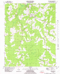 1982 Powellsville1982 Print · USGSBertie and Hertford counties appear in the early eighties as a rural landscape of vast wetlands and small farming crossroads. Genealogists can trace family roots at Highland Mem Cem or locate historic congregation sites like Holly Grove Ch and Piney Wood Chapel.
 - 1982 Map of Winton
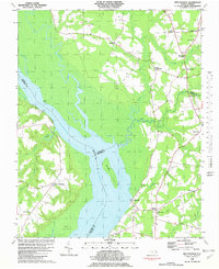
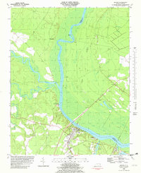 1982 Winton1982 Print · USGSHertford and Gates Counties are mapped here in the early eighties as the riverfront communities along the Chowan River evolved. Genealogists and local historians can trace family-named sites like Askew Cem, Mt Moriah Ch, and the Brown Sch.
 - 1982 Map of Valhalla
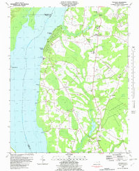 1982 Valhalla1982 Print · USGSThe Chowan River shoreline and the rural crossroads of eastern North Carolina come alive in this early 1980s survey. Genealogists and local historians can trace family roots through landmarks like Chowan Academy, White Oak Ch, and Dillard Millpond.
 - 1982 Map of Mintonsville
 1982 Mintonsville1982 Print · USGSCoastal plains and riverine wetlands characterize this corner of North Carolina in the early eighties. Genealogists and historians can trace family-named crossroads and landmarks like Cannon Ferry, Walton Grove Ch, and Lloyd Crossroads.
 - 1982 Map of Colerain
 1982 Colerain1982 Print · USGSBertie County farmland and riverfront meet the Chowan River in the early eighties. Researchers can trace rural lineages through numerous country churches like Mars Hill Ch and crossroads settlements such as Wakelon, Trap, and Glovers Crossroads.
 - 1982 Map of Harrellsville
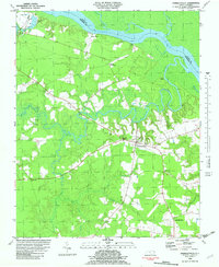 1982 Harrellsville1982 Print · USGSHarrellsville and the Wiccacon River lowlands are captured here in the early eighties as the region balanced rural farming with its river-port heritage. Researchers can locate family landmarks such as Newsome Store, Cherry Sch, and the Mt Pleasant Ch.
 - 1982 Map of Ahoskie
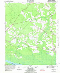
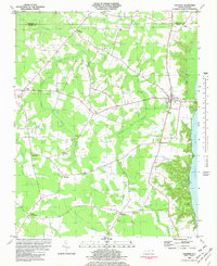
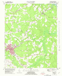 1982 Ahoskie1982 Print · USGSHertford County thrives as a rail and agricultural hub in the early eighties, centered on the growing town of Ahoskie. Trace old family roots at Brinkley Cem or explore the rail networks connecting Tunis and Cofield near the Wiccacon River.
 - 1984 Map of Emporia, 1986 Print
 1984 Emporia1986 Print · USGSSouthside Virginia and the North Carolina borderlands are captured here in the mid-1980s, centered on the transit hub of Emporia. Researchers can trace old rail corridors like the Seaboard System or locate historic sites including Fort Christanna and White Oak Ch.
 - 1985 Map of Elizabeth City
 1985 Elizabeth City1985 Print · USGSCoastal North Carolina's rivers and sounds define the landscape of the mid-eighties, from the vast swamps to the historical waterfronts of Elizabeth City and Edenton. Researchers can trace the rail lines of the Southern Ry or locate landmarks like Beaver Hill Cem and South Mills.2 unique versions available
 - 1985 Map of Roanoke Rapids
 1985 Roanoke Rapids1985 Print · USGSNorthern North Carolina's river-driven economy is on display here in the mid-1980s, from the hydro-power at Roanoke Rapids to the rural millponds. Genealogists can trace family lands near Wiccacanee Pond, Mush Island, or the remote Urahaw Swamp.2 unique versions available
 - 1985 Map of Norfolk, 1986 Print
 1985 Norfolk1986 Print · USGSThe Tidewater region in the mid-eighties shows the dense urban expansion of the coastal cities alongside the preservation of the Great Dismal Swamp. Researchers can trace rural family-named crossroads and historic transit routes like the Seaboard Coast Line or find Somerton and Lake Drummond.3 unique versions available
End of results
Showing maps 1-12 of 12
Top cities of Hertford County
- Ahoskie historical maps
- Murfreesboro historical maps
- Winton historical maps
- Cofield historical maps
- Harrellsville historical maps
- Como historical maps
Frequently asked questions
- What are the different types of historical maps available for Hertford County?
- What is the oldest map of Hertford County?
- Where can I purchase historical maps of Hertford County for my home or office?
- Where can I download high-res historical maps of Hertford County?
- Are there historical topographic maps available for Hertford County?
- Is there historical aerial imagery available for Hertford County?
- Where are historical maps of Hertford County sourced from?