1940s Maps of Hyde County, North Carolina
Explore 5 historic maps of Hyde County from the 1940s. These maps offer a rare glimpse into what life looked like during the 1940s — showing old roads, neighborhoods, homes, and landmarks that have changed or disappeared over time.
Whether you're researching your family's past, planning a metal detecting trip, or studying how Hyde County's landscape evolved across the 1940s, these high-resolution maps are a powerful tool for exploring the history of this region.
- Focus on a specific era: All maps on this page are from the 1940s, giving you a focused view of this time period.
- See what’s changed: Compare century-old streets, trails, and buildings to today's modern landscape using overlays and satellite layers.
- Research with precision: Use these maps for genealogy, historical research, land use analysis, or educational projects.
- View, download, or print: Maps are fully viewable online in high resolution, and can be downloaded or printed for your own records.
Start exploring Hyde County's history through authentic maps from the 1940s. This is your window into the past.
Hyde County, NC maps
(5)- 1943 Map of Columbia
 1943 Columbia1943 Print · USGSCoastal Tyrrell and Hyde Counties are captured in the early 1940s, showing a landscape defined by timber industry and federal land projects. Researchers can trace the industrial docks at the Richmond Cedar Works Lumber Mill or locate the rural Scuppernong Farms (F.S.A.).
 - 1943 Map of Plymouth
 1943 Plymouth1943 Print · USGSThe coastal plains and swamps of eastern North Carolina are captured here during the wartime era, showing a landscape defined by river navigation and drainage canals. Genealogists can trace family roots through rural landmarks like Ellis Store, St Lukes Ch, and small rail stops such as Acre Sta.
 - 1943 Map of Roanoke Island
 1943 Roanoke Island1943 Print · USGSCoastal North Carolina during the war years shows a network of maritime outposts and isolated mainland settlements connected by ferry. Trace the old village of Buffalo City, locate the Bodie Island Lighthouse, and find historic Coast Guard stations at Nags Head and Chicamacomico CG.
 - 1948 Map of Portsmouth, 1976 Print
 1948 Portsmouth1976 Print · USGSThe Outer Banks at Portsmouth Island are captured here during the mid-1940s, showing a remote maritime community before modern coastal changes. Trace the docks at Portsmouth, find navigation aids like Shell Castle, and locate the ferry routes that linked these isolated shoals.2 unique versions available
 - 1948 Map of Ocracoke, 1984 Print
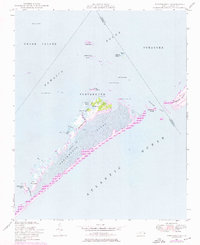
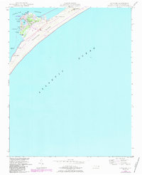 1948 Ocracoke1984 Print · USGSThe outer banks of North Carolina are captured here just as the national seashore was being established after the war. You can trace the village of Ocracoke around the harbor at Silver Lake, locating the Ocracoke Light and the nearby Coast Guard Sta.2 unique versions available
End of results
Showing maps 1-5 of 5
Top cities of Hyde County
Frequently asked questions
- What are the different types of historical maps available for Hyde County?
- What is the oldest map of Hyde County?
- Where can I purchase historical maps of Hyde County for my home or office?
- Where can I download high-res historical maps of Hyde County?
- Are there historical topographic maps available for Hyde County?
- Is there historical aerial imagery available for Hyde County?
- Where are historical maps of Hyde County sourced from?