1990s Maps of Pine Level, North Carolina
Explore 3 historic maps of Pine Level from the 1990s. These maps offer a rare glimpse into what life looked like during the 1990s — showing old roads, neighborhoods, homes, and landmarks that have changed or disappeared over time.
Whether you're researching your family's past, planning a metal detecting trip, or studying how Pine Level's landscape evolved across the 1990s, these high-resolution maps are a powerful tool for exploring the history of this region.
- Focus on a specific era: All maps on this page are from the 1990s, giving you a focused view of this time period.
- See what’s changed: Compare century-old streets, trails, and buildings to today's modern landscape using overlays and satellite layers.
- Research with precision: Use these maps for genealogy, historical research, land use analysis, or educational projects.
- View, download, or print: Maps are fully viewable online in high resolution, and can be downloaded or printed for your own records.
Start exploring Pine Level's history through authentic maps from the 1990s. This is your window into the past.
Pine Level, NC maps
(3)- 1990 Map of Raleigh, 1991 Print
 1990 Raleigh1991 Print · USGSGreater Raleigh and the Research Triangle entered a period of significant suburban growth during the 1990s. Researchers can trace the development of towns like Fuquay-Varina and Wake Forest or locate landmarks such as the State Prison and Harris Reservoir.2 unique versions available
 - 1997 Map of Four Oaks NE, 2000 Print
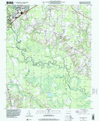 1997 Four Oaks NE2000 Print · USGSThe riverfront and rural outskirts of Johnston County come alive in the late nineties, where the winding Neuse River meets the growing edge of Smithfield. Researchers can trace the location of numerous country churches and landmarks like Sanders Chapel, The Cowbone, and Polecat Landing.
 - 1998 Map of Selma, 2000 Print
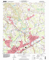 1998 Selma2000 Print · USGSThe Johnston County corridor at the close of the century shows a landscape where historic rural settlements meet modern regional infrastructure. Genealogists can trace family landmarks like Lassiter Cem and Yelverton Grove Ch alongside civic hubs like the Johnston County Hospital.
End of results
Showing maps 1-3 of 3
Top cities near Pine Level
- Raleigh historical maps
- Wilson historical maps
- Goldsboro historical maps
- Clayton historical maps
- Smithfield historical maps
- Selma historical maps
See more
Frequently asked questions
- What are the different types of historical maps available for Pine Level?
- What is the oldest map of Pine Level?
- Where can I purchase historical maps of Pine Level for my home or office?
- Where can I download high-res historical maps of Pine Level?
- Are there historical topographic maps available for Pine Level?
- Is there historical aerial imagery available for Pine Level?
- Where are historical maps of Pine Level sourced from?