1970s Maps of Pine Level, North Carolina
Explore 2 historic maps of Pine Level from the 1970s. These maps offer a rare glimpse into what life looked like during the 1970s — showing old roads, neighborhoods, homes, and landmarks that have changed or disappeared over time.
Whether you're researching your family's past, planning a metal detecting trip, or studying how Pine Level's landscape evolved across the 1970s, these high-resolution maps are a powerful tool for exploring the history of this region.
- Focus on a specific era: All maps on this page are from the 1970s, giving you a focused view of this time period.
- See what’s changed: Compare century-old streets, trails, and buildings to today's modern landscape using overlays and satellite layers.
- Research with precision: Use these maps for genealogy, historical research, land use analysis, or educational projects.
- View, download, or print: Maps are fully viewable online in high resolution, and can be downloaded or printed for your own records.
Start exploring Pine Level's history through authentic maps from the 1970s. This is your window into the past.
Pine Level, NC maps
(2)- 1974 Map of Princeton, 1976 Print
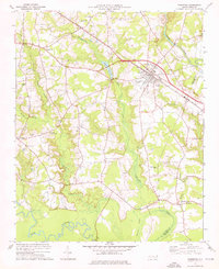 1974 Princeton1976 Print · USGSNear the Johnston and Wayne county line in the mid-1970s, this area centers on the railroad town of Princeton and its surrounding wetlands. Local historians can locate numerous rural landmarks like Bakers Chapel, Raynor Town, and Bizzell Grove Memorial Gardens.
 - 1978 Map of Kenly West
 1978 Kenly West1978 Print · USGSThe rural landscape of Johnston County is captured here in the late seventies, showing a network of railroad towns and farming crossroads. Researchers can trace local heritage through landmarks like Lowell Mill, Oak Grove Inn, and churches such as Bethany Ch.
End of results
Showing maps 1-2 of 2
Top cities near Pine Level
- Raleigh historical maps
- Wilson historical maps
- Goldsboro historical maps
- Clayton historical maps
- Smithfield historical maps
- Selma historical maps
See more
Frequently asked questions
- What are the different types of historical maps available for Pine Level?
- What is the oldest map of Pine Level?
- Where can I purchase historical maps of Pine Level for my home or office?
- Where can I download high-res historical maps of Pine Level?
- Are there historical topographic maps available for Pine Level?
- Is there historical aerial imagery available for Pine Level?
- Where are historical maps of Pine Level sourced from?