1900-1909 Maps of Martin County, North Carolina
Explore 6 historic maps of Martin County from 1900-1909. These maps offer a rare glimpse into what life looked like during the 1900s — showing old roads, neighborhoods, homes, and landmarks that have changed or disappeared over time.
Whether you're researching your family's past, planning a metal detecting trip, or studying how Martin County's landscape evolved across the 1900s, these high-resolution maps are a powerful tool for exploring the history of this region.
- Focus on a specific era: All maps on this page are from the 1900s, giving you a focused view of this time period.
- See what’s changed: Compare century-old streets, trails, and buildings to today's modern landscape using overlays and satellite layers.
- Research with precision: Use these maps for genealogy, historical research, land use analysis, or educational projects.
- View, download, or print: Maps are fully viewable online in high resolution, and can be downloaded or printed for your own records.
Start exploring Martin County's history through authentic maps from the 1900s. This is your window into the past.
Martin County, NC maps
(6)- 1901 Map of Parmele, 1971 Print
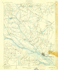
 1901 Parmele1971 Print · USGSCoastal plain North Carolina at the turn of the century is defined here by the converging tracks at Parmele and the dense swampy lowlands. Genealogists can trace early homesteads and community hubs like Shiloh Mills, Dogtown, and the old Tram Road.
 - 1901 Map of Williamston, 1972 Print
 1901 Williamston1972 Print · USGSThe Roanoke River basin at the turn of the century shows a thriving network of steamboat landings and new rail lines. Genealogists and researchers can trace the river economy through Spellers Ferry Landing, Grabtown, and the Atlantic Coast Line R. R.
 - 1902 Map of Williamston, 1944 Print
 1902 Williamston1944 Print · USGSMartin County’s riverfront and rail corridors are frozen in time here at the dawn of the twentieth century. Genealogists and local historians can trace family roots through landings like Spellers Ferry Landing or settlements at Everetts and Goldpoint.
 - 1902 Map of Parmele, 1959 Print
 1902 Parmele1959 Print · USGSCoastal Plain North Carolina at the turn of the century shows a landscape defined by the arrival of the railroad. Genealogists and local historians can trace family roots in early settlements like Conetoe, Shiloh Mills, and the rail junction at Parmele.
 - 1903 Map of Chocowinity, 1968 Print
 1903 Chocowinity1968 Print · USGSCoastal North Carolina comes alive in the early 1900s as steam power and rail lines intersect along the banks of the Tar River. Researchers can trace old river landings like Yankee Hall Ldg. and family-named landmarks including Woolard Crossroads and Shepherd Millpond.
 - 1905 Map of Chocowinity
 1905 Chocowinity1905 Print · USGSCoastal North Carolina during the early 1900s centered on the busy waterways of the Tar River and the growing town of Washington. Genealogists and historians can trace old river landings such as Yankee Hall Ldg. and rural sites like Leggetts Crossroads or Pactolus.3 unique versions available
End of results
Showing maps 1-6 of 6
Top cities of Martin County
- Williamston historical maps
- Robersonville historical maps
- Hamilton historical maps
- Jamesville historical maps
- Oak City historical maps
- Parmele historical maps
See more
Frequently asked questions
- What are the different types of historical maps available for Martin County?
- What is the oldest map of Martin County?
- Where can I purchase historical maps of Martin County for my home or office?
- Where can I download high-res historical maps of Martin County?
- Are there historical topographic maps available for Martin County?
- Is there historical aerial imagery available for Martin County?
- Where are historical maps of Martin County sourced from?