1990s Maps of Martin County, North Carolina
Explore 6 historic maps of Martin County from the 1990s. These maps offer a rare glimpse into what life looked like during the 1990s — showing old roads, neighborhoods, homes, and landmarks that have changed or disappeared over time.
Whether you're researching your family's past, planning a metal detecting trip, or studying how Martin County's landscape evolved across the 1990s, these high-resolution maps are a powerful tool for exploring the history of this region.
- Focus on a specific era: All maps on this page are from the 1990s, giving you a focused view of this time period.
- See what’s changed: Compare century-old streets, trails, and buildings to today's modern landscape using overlays and satellite layers.
- Research with precision: Use these maps for genealogy, historical research, land use analysis, or educational projects.
- View, download, or print: Maps are fully viewable online in high resolution, and can be downloaded or printed for your own records.
Start exploring Martin County's history through authentic maps from the 1990s. This is your window into the past.
Martin County, NC maps
(6)- 1997 Map of Woodard, 2000 Print
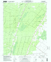
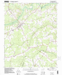 1997 Woodard2000 Print · USGSCoastal plain settlements and low-lying creek systems defined this North Carolina interior in the 1990s. Researchers can trace rural church history and family plots at Jerusalem Ch, Eagletown, and Mintons Store while following the path of Catawhiskie Creek.
 - 1997 Map of Palmyra, 2000 Print
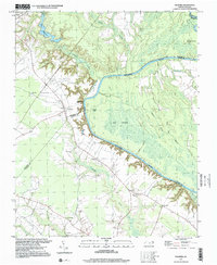 1997 Palmyra2000 Print · USGSThe Roanoke River lowlands and the community of Palmyra are captured here in the late 1990s as a complex network of wetlands and rural homesteads. Genealogists and local historians can trace family ties through numerous sites like Hills Ferry, Johnandrus Ch, and Stephenson Cem.
 - 1997 Map of Hobgood, 2000 Print
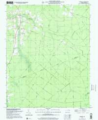
 1997 Hobgood2000 Print · USGSCoastal plain settlements and family crossroads define this North Carolina landscape in the late nineties. Researchers can trace ancestral locations through dozens of named sites like Leggett House Cem, Shield Sch, and Mullins Crossroads.
 - 1997 Map of Farmlife, 2001 Print
 1997 Farmlife2001 Print · USGSThe coastal plain of Martin and Beaufort counties comes into focus in the late nineties, showing a landscape defined by drainage canals and rural tradition. Genealogists can locate Manning Cem, Maple Grove Ch, and the Manning Farmlife Sch.
 - 1997 Map of Hoke, 2001 Print
 1997 Hoke2001 Print · USGSCoastal North Carolina at the end of the millennium is characterized here by its vast wetlands and rural railroad hamlets. Genealogists and historians can trace family plots near Christian Hope Ch or follow old timber routes like the Morris Tram Road near Hoke.
 - 1998 Map of Plymouth West, 2001 Print
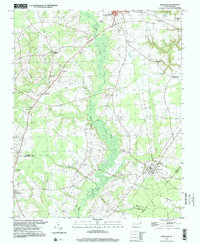
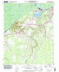 1998 Plymouth West2001 Print · USGSMartin County in the late 1990s is captured here at the intersection of river-driven industry and deep rural heritage. Researchers can trace the layout of Plymouth and locate rural landmarks such as Poplar Chapel, Corinth Ch, and the small settlement of Dardens.
End of results
Showing maps 1-6 of 6
Top cities of Martin County
- Williamston historical maps
- Robersonville historical maps
- Hamilton historical maps
- Jamesville historical maps
- Oak City historical maps
- Parmele historical maps
See more
Frequently asked questions
- What are the different types of historical maps available for Martin County?
- What is the oldest map of Martin County?
- Where can I purchase historical maps of Martin County for my home or office?
- Where can I download high-res historical maps of Martin County?
- Are there historical topographic maps available for Martin County?
- Is there historical aerial imagery available for Martin County?
- Where are historical maps of Martin County sourced from?