1930s Maps of McDowell County, North Carolina
Explore 6 historic maps of McDowell County from the 1930s. These maps offer a rare glimpse into what life looked like during the 1930s — showing old roads, neighborhoods, homes, and landmarks that have changed or disappeared over time.
Whether you're researching your family's past, planning a metal detecting trip, or studying how McDowell County's landscape evolved across the 1930s, these high-resolution maps are a powerful tool for exploring the history of this region.
- Focus on a specific era: All maps on this page are from the 1930s, giving you a focused view of this time period.
- See what’s changed: Compare century-old streets, trails, and buildings to today's modern landscape using overlays and satellite layers.
- Research with precision: Use these maps for genealogy, historical research, land use analysis, or educational projects.
- View, download, or print: Maps are fully viewable online in high resolution, and can be downloaded or printed for your own records.
Start exploring McDowell County's history through authentic maps from the 1930s. This is your window into the past.
McDowell County, NC maps
(6)- 1934 Map of Spruce Pine
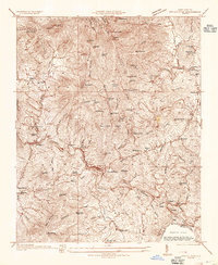 1934 Spruce Pine1934 Print · USGSMitchell County industrial and mountain life are captured in the mid-1930s as the local mining economy thrived. Genealogists and historians can trace families near Spruce Pine, locate the Prison Camp, and identify remote sites like Wolfden Mine and Hunter Chapel.
 - 1934 Map of Parts Of Celo And Black Brothers
 1934 Parts Of Celo And Black Brothers1934 Print · USGSYancey County's high-country settlements and forest boundaries are meticulously detailed in this mid-1930s survey. Researchers can locate community hubs like Harvard Sch and Edges Store or trace the steep terrain of Mt Mitchell.
 - 1934 Map of Parts Of Old Fort and Montreat
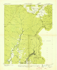
 1934 Parts Of Old Fort and Montreat1934 Print · USGSThe Black Mountains reached a turning point in the mid-1930s as state and national parklands began to formalize. You can trace the early Blue Ridge Parkway, find the remote Loftis Cabin, and locate the Green Knob Fire Tower.
 - 1934 Map of Linville Falls
 1934 Linville Falls1934 Print · USGSAvery County mountain life in the mid-thirties centered on the North Toe River and its rugged ridges. Genealogists can locate family landmarks like Walnut Grove Ch, Brushy Creek Sch, and the Hemphill Mine near the crossing at Heffner Gap.
 - 1935 Map of Montreat
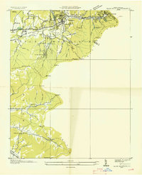
 1935 Montreat1935 Print · USGSMontreat and the surrounding Black Mountains are shown here in the mid-1930s, documenting the area's religious centers and early park development. Genealogists and hikers can trace the Toll Road up to Clingmans Peak or locate old community landmarks like Brookside Sch and Homers Chapel.
 - 1935 Map of Black Mountain
 1935 Black Mountain1935 Print · USGSBuncombe County in the mid-1930s reveals a landscape shaped by mountain transit and social institutions. Genealogists can locate family landmarks like Tabernacle Ch, Pleasant Grove Sch, and the remote Mountain Orphanage along the rail-and-river corridor.
End of results
Showing maps 1-6 of 6
Top cities of McDowell County
Frequently asked questions
- What are the different types of historical maps available for McDowell County?
- What is the oldest map of McDowell County?
- Where can I purchase historical maps of McDowell County for my home or office?
- Where can I download high-res historical maps of McDowell County?
- Are there historical topographic maps available for McDowell County?
- Is there historical aerial imagery available for McDowell County?
- Where are historical maps of McDowell County sourced from?