1990s Maps of McDowell County, North Carolina
Explore 17 historic maps of McDowell County from the 1990s. These maps offer a rare glimpse into what life looked like during the 1990s — showing old roads, neighborhoods, homes, and landmarks that have changed or disappeared over time.
Whether you're researching your family's past, planning a metal detecting trip, or studying how McDowell County's landscape evolved across the 1990s, these high-resolution maps are a powerful tool for exploring the history of this region.
- Focus on a specific era: All maps on this page are from the 1990s, giving you a focused view of this time period.
- See what’s changed: Compare century-old streets, trails, and buildings to today's modern landscape using overlays and satellite layers.
- Research with precision: Use these maps for genealogy, historical research, land use analysis, or educational projects.
- View, download, or print: Maps are fully viewable online in high resolution, and can be downloaded or printed for your own records.
Start exploring McDowell County's history through authentic maps from the 1990s. This is your window into the past.
McDowell County, NC maps
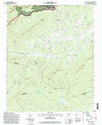
(17)- 1993 Map of Dysartsville, 1996 Print
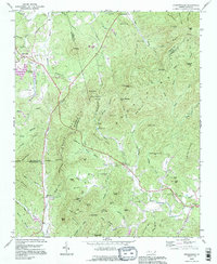 1993 Dysartsville1996 Print · USGSThe tri-county borderlands of North Carolina come into focus during the mid-nineties, showing a landscape defined by the First Broad River and rural crossroads. Genealogists can trace family landmarks near Dysartsville, Golden Valley, and rural congregations like Missionary Ch.
 - 1993 Map of Ashford, 1996 Print
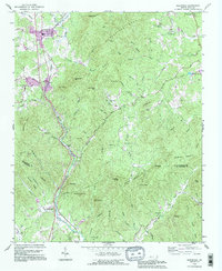
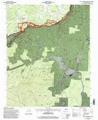
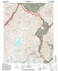
 1993 Ashford1996 Print · USGSThe northern shores of Lake James and the steep descent into the Linville Gorge Wilderness Area define this McDowell and Burke County landscape in the 1990s. Researchers can locate the South Mtn Institute, Brown Cem, and the community of Ashford.
 - 1993 Map of Glenwood, 1996 Print
 1993 Glenwood1996 Print · USGSThe McDowell and Rutherford County borderlands come into focus in the 1990s as the Second Broad River flows past small rail towns. Genealogists can trace family footprints at Brackettown Cem or follow the SOUTHERN line through Glenwood and Thermal City.
 - 1993 Map of Glen Alpine, 1996 Print
 1993 Glen Alpine1996 Print · USGSBurke County in the early nineties shows a landscape shaped by the Catawba River and the expanding infrastructure around Glen Alpine. Researchers can trace old family sites near Brindletown or locate rural landmarks like Snow Hill Ch and Me Alpine Sch.
 - 1993 Map of Marion East, 1996 Print
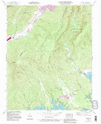
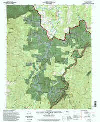
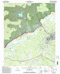
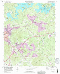 1993 Marion East1996 Print · USGSMcDowell County in the 1990s shows a landscape of growing communities and mountain industry between the Blue Ridge foothills and the waters of Lake James. Family historians can trace local landmarks like Nebo High Sch, Oak Grove Cem, and Parkers Chapel.
 - 1994 Map of Linville Falls, 1996 Print
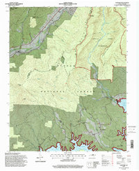
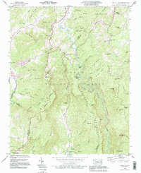 1994 Linville Falls1996 Print · USGSThe Blue Ridge high country of western North Carolina is documented here in the mid-nineties, centered on the dramatic descent of the Linville River. Researchers can locate family landmarks like Wise Cem and Pisgah Ch near the historic Linville Caverns.2 unique versions available
 - 1994 Map of Marion East, 1998 Print
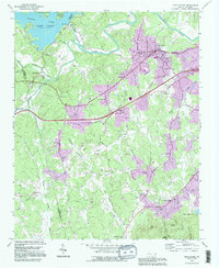
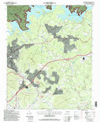 1994 Marion East1998 Print · USGSMcDowell County's eastern reaches are captured here in the mid-nineties, showing the integration of Lake James with the rail-side growth of Marion. Researchers can pinpoint local landmarks from the State Prison Camp to rural congregations like Drusilla Church and Fairview Church.
 - 1994 Map of Spruce Pine, 1998 Print
 1994 Spruce Pine1998 Print · USGSSpruce Pine and the North Toe River valley are shown here in the mid-1990s as the local economy balanced mountain industry with preservation. Genealogists can trace family names at the Spruce Pine Memorial Cem or McKinney Cem, while collectors can locate old rail landmarks along the Clinchfield RR.
 - 1994 Map of Celo, 1998 Print
 1994 Celo1998 Print · USGSThe South Toe River valley in the 1990s offers a detailed view of Appalachian settlement and forestry. Researchers can trace family names at the Gibbs Cemetery or Robinson Cemetery, and locate rural landmarks like the South Toe River School.
 - 1994 Map of Little Switzerland, 1998 Print
 1994 Little Switzerland1998 Print · USGSLittle Switzerland and the high ridges of the Blue Ridge were undergoing updated federal survey in the mid-nineties. You can trace the intricate path of the Blue Ridge Parkway or locate family history at Chestnut Grove Ch, Hollyfield Cem, and the cluster of mountain tunnels near The Loop.
 - 1994 Map of Ashford, 1998 Print
 1994 Ashford1998 Print · USGSThe McDowell and Burke county lines meet here in the 1990s as high mountain wilderness gives way to the backwaters of the Catawba. Trace the route of the Clinchfield RR or locate historic sites like the South Mountain Institute and Brown Cemetery.2 unique versions available
 - 1994 Map of Glen Alpine, 1998 Print
 1994 Glen Alpine1998 Print · USGSWestern North Carolina's Catawba Valley comes into focus in the mid-1990s as the river basin meets the foothills of the Pisgah Forest. Researchers can trace family roots through numerous local landmarks like Mt Herman Church, Mc Alpine School, and the settlement of Bridgewater.
 - 1994 Map of Montreat, 1998 Print
 1994 Montreat1998 Print · USGSHigh peaks and protected watersheds dominate the Buncombe County landscape in the 1990s as the Blue Ridge Parkway skirts the eastern ridges. Researchers can trace the grounds of Black Mountain College or locate the Graphite Mine and Homers Chapel in the valleys below.
 - 1994 Map of Marion West, 1998 Print
 1994 Marion West1998 Print · USGSThe foothills of the Blue Ridge come into focus in the mid-1990s, showing the Catawba River valley as it nears the city of Marion. Genealogists and local historians can trace family-named sites and rural institutions like Carsons Chapel, Garden Creek, and the Zion Hill Cemetery.
 - 1994 Map of Black Mountain, 1998 Print
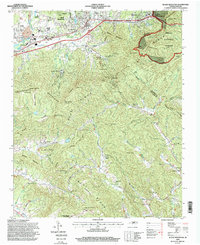 1994 Black Mountain1998 Print · USGSBuncombe and McDowell counties appear in the mid-1990s as a high-altitude crossroads for the railway and Interstate 40. Researchers can trace the legacy of local institutions like the Mountain Orphanage and find family landmarks such as Wilkes Church or the Swannanoa Tunnel.
 - 1994 Map of Old Fort, 1998 Print
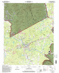
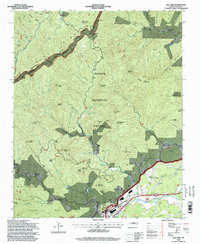 1994 Old Fort1998 Print · USGSWestern North Carolina's high-country transition is captured in the mid-1990s as the Blue Ridge meets the Catawba River valley. Genealogists and hikers can trace family landmarks and backcountry trails through Old Fort, Siloam Cemeteries, and Piney Grove Church.
 - 1994 Map of Moffitt Hill, 1998 Print
 1994 Moffitt Hill1998 Print · USGSThe Blue Ridge foothills of McDowell County are shown in the mid-nineties as a network of mountain communities and forest lands. Genealogists and hikers can trace old family sites and mountain routes near Old Fort, Lackey Town, and Catawba Falls.
End of results
Showing maps 1-17 of 17
Top cities of McDowell County
Frequently asked questions
- What are the different types of historical maps available for McDowell County?
- What is the oldest map of McDowell County?
- Where can I purchase historical maps of McDowell County for my home or office?
- Where can I download high-res historical maps of McDowell County?
- Are there historical topographic maps available for McDowell County?
- Is there historical aerial imagery available for McDowell County?
- Where are historical maps of McDowell County sourced from?