1940s Maps of McDowell County, North Carolina
Explore 4 historic maps of McDowell County from the 1940s. These maps offer a rare glimpse into what life looked like during the 1940s — showing old roads, neighborhoods, homes, and landmarks that have changed or disappeared over time.
Whether you're researching your family's past, planning a metal detecting trip, or studying how McDowell County's landscape evolved across the 1940s, these high-resolution maps are a powerful tool for exploring the history of this region.
- Focus on a specific era: All maps on this page are from the 1940s, giving you a focused view of this time period.
- See what’s changed: Compare century-old streets, trails, and buildings to today's modern landscape using overlays and satellite layers.
- Research with precision: Use these maps for genealogy, historical research, land use analysis, or educational projects.
- View, download, or print: Maps are fully viewable online in high resolution, and can be downloaded or printed for your own records.
Start exploring McDowell County's history through authentic maps from the 1940s. This is your window into the past.
McDowell County, NC maps
(4)- 1941 Map of Black Mountain, 1957 Print
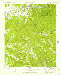 1941 Black Mountain1957 Print · USGSThe Swannanoa Valley and the Blue Ridge crest come alive in this early 1940s survey. Genealogists can trace the institutional history of the State Hospital or locate family landmarks like Tabernacle Ch and Curteys Chapel.6 unique versions available
 - 1942 Map of Montreat, 1957 Print
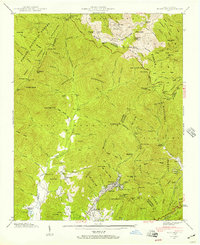 1942 Montreat1957 Print · USGSThe high peaks of Buncombe County are captured in the early 1940s, showing the settled valleys of Montreat and Walkertown before postwar development. Genealogists and historians can trace local landmarks like Mtn View Cem, find family-named points like Allen Mtn, and locate the Southern Railway route through Jarrett Tunnel.5 unique versions available
 - 1943 Map of Black Mountain
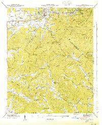 1943 Black Mountain1943 Print · USGSThe Black Mountain area in the early 1940s served as a critical hub for mountain institutions, from religious retreats to state health facilities. Researchers can trace the path of the Southern Railway through the Swannanoa Gap or locate family-named landmarks like Isinglass Ridge and Garren Mountain.
 - 1943 Map of Montreat
 1943 Montreat1943 Print · USGSBuncombe County's mountain coves and the Blue Ridge Parkway are detailed here during the mid-1940s. Researchers can trace the early grounds of Black Mtn College, locate families near Walkertown, or find industrial sites like the Graphite mine.2 unique versions available
End of results
Showing maps 1-4 of 4
Top cities of McDowell County
Frequently asked questions
- What are the different types of historical maps available for McDowell County?
- What is the oldest map of McDowell County?
- Where can I purchase historical maps of McDowell County for my home or office?
- Where can I download high-res historical maps of McDowell County?
- Are there historical topographic maps available for McDowell County?
- Is there historical aerial imagery available for McDowell County?
- Where are historical maps of McDowell County sourced from?