1990s Maps of Nash County, North Carolina
Explore 6 historic maps of Nash County from the 1990s. These maps offer a rare glimpse into what life looked like during the 1990s — showing old roads, neighborhoods, homes, and landmarks that have changed or disappeared over time.
Whether you're researching your family's past, planning a metal detecting trip, or studying how Nash County's landscape evolved across the 1990s, these high-resolution maps are a powerful tool for exploring the history of this region.
- Focus on a specific era: All maps on this page are from the 1990s, giving you a focused view of this time period.
- See what’s changed: Compare century-old streets, trails, and buildings to today's modern landscape using overlays and satellite layers.
- Research with precision: Use these maps for genealogy, historical research, land use analysis, or educational projects.
- View, download, or print: Maps are fully viewable online in high resolution, and can be downloaded or printed for your own records.
Start exploring Nash County's history through authentic maps from the 1990s. This is your window into the past.
Nash County, NC maps
(6)- 1990 Map of Raleigh, 1991 Print
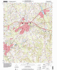
 1990 Raleigh1991 Print · USGSGreater Raleigh and the Research Triangle entered a period of significant suburban growth during the 1990s. Researchers can trace the development of towns like Fuquay-Varina and Wake Forest or locate landmarks such as the State Prison and Harris Reservoir.2 unique versions available
 - 1991 Map of Henderson
 1991 Henderson1991 Print · USGSThe northern Piedmont and Virginia borderlands come into focus in the early nineties, showing a landscape defined by major reservoirs and growing towns. Trace the rail-and-road connections between Oxford, Henderson, and Durham while exploring the developing shores of Falls Lake.2 unique versions available
 - 1998 Map of Rocky Mount, 2000 Print
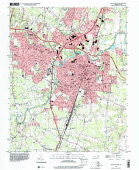 1998 Rocky Mount2000 Print · USGSRocky Mount and its surrounding Nash County suburbs are seen here in the late nineties as the city expanded westward toward the hospital. Genealogists can trace community roots through numerous local churches like Dortches Ch and the residential streets of South Rocky Mount.
 - 1998 Map of Essex, 2000 Print
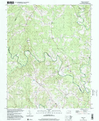 1998 Essex2000 Print · USGSHalifax and Nash Counties at the turn of the millennium remained a landscape of quiet rural crossroads and deep swamp forests. Genealogists and local historians can trace family roots through numerous sites like Aventon, Walters Chapel, and the Saunders Cem.
 - 1998 Map of Winstead Crossroads, 2001 Print
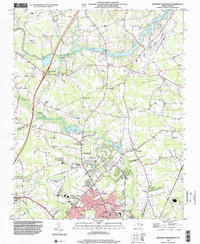 1998 Winstead Crossroads2001 Print · USGSWilson and its northern rural reaches are shown in the late nineties as they transition from agrarian crossroads to modern development. Genealogists can trace family landmarks and rural congregations like Rick Grove Ch, Dunn Crossroads, and the sprawling Evergreen Memorial Gardens.
 - 1999 Map of Zebulon, 2000 Print
 1999 Zebulon2000 Print · USGSZebulon and Wendell were thriving hubs in eastern Wake County at the turn of the millennium. Researchers can trace the layout of regional schools like Wakelon High School and locate rural landmarks such as Lizard Lick and Earpsboro.
End of results
Showing maps 1-6 of 6
Top cities of Nash County
- Nashville historical maps
- Red Oak historical maps
- Spring Hope historical maps
- Middlesex historical maps
- Dortches historical maps
- Bailey historical maps
See more
Frequently asked questions
- What are the different types of historical maps available for Nash County?
- What is the oldest map of Nash County?
- Where can I purchase historical maps of Nash County for my home or office?
- Where can I download high-res historical maps of Nash County?
- Are there historical topographic maps available for Nash County?
- Is there historical aerial imagery available for Nash County?
- Where are historical maps of Nash County sourced from?