Old Maps of Nash County, North Carolina for Genealogy
Trace your family roots with 140 historic maps of Nash County. These high-res maps reveal old neighborhoods, homesites, landmarks, and streets — helping you uncover where your ancestors lived and how the area evolved over time.
- Explore historic neighborhoods: Identify where your relatives may have lived in the 1800s or 1900s.
- Compare maps over time: Trace the changes in streets, buildings, and landmarks for multi-generational research.
- Perfect for genealogy & ancestry research: Used by family historians and researchers to map out lineage and migration.
These maps are an incredible resource for exploring your personal connection to Nash County's past.
Nash County, NC maps
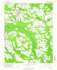
(140)- 1902 Map of Kenly
 1902 Kenly1902 Print · USGSCoastal plain settlements in Johnston and Wilson Counties flourished along the rail lines during the early nineteen-hundreds. Genealogists can locate family landmarks like Moores Crossroads and Hares Crossroads or trace the Atlantic Coast Line through Kenly and Micro.2 unique versions available
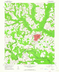
 - 1902 Map of Rocky Mount, 1965 Print
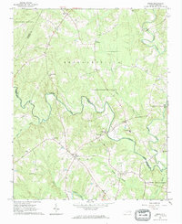
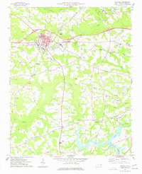
 1902 Rocky Mount1965 Print · USGSThe coastal plain of North Carolina comes alive in this early survey of the rail and river corridors between Nashville and Rocky Mount. Genealogists can trace early landmarks like Snells Crossroads, the Rocky Mount Mills, and Elm City.
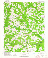
 - 1902 Map of Spring Hope, 1965 Print
 1902 Spring Hope1965 Print · USGSNash and Franklin Counties are seen here at the turn of the century as a landscape of river-bend settlements and railroad progress. Researchers can trace ancestral roots through family-named landmarks like Lamm Crossroads, Lee Chapel, and Pine Ridge Schoolhouse.
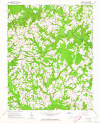
 - 1903 Map of Kenly
 1903 Kenly1903 Print · USGSCoastal plain settlements and crossroads thrive along the rail corridors of Johnston and Wilson counties at the dawn of the twentieth century. Genealogists can locate family-named sites like Hornes Mill and Barnes Store or trace the early paths through Beulahtown and Kenly.2 unique versions available
 - 1904 Map of Rocky Mount, 1942 Print
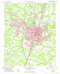
 1904 Rocky Mount1942 Print · USGSThe Tar River and the rail hubs of eastern North Carolina come alive in this early twentieth-century survey. Genealogists and local historians can trace the growth of Rocky Mount and Nashville, or locate vanished industrial landmarks like the Upper Falls Rocky Mount Mills and Finch Mill.
 - 1904 Map of Springhope, 1942 Print
 1904 Springhope1942 Print · USGSNash County at the turn of the century shows a rural landscape connected by the Atlantic Coast Line R. R. and the winding Tar River. Researchers can trace ancestral locations at Lamm Crossroads, Whiteoak Church, and the Pine Ridge Schoolhouse.
 - 1953 Map of Norfolk, 1954 Print
 1953 Norfolk1954 Print · USGSCoastal Virginia and northeastern North Carolina appear here during the post-war industrial boom, showing the critical rail-and-sea connections of Hampton Roads. Genealogists can trace family roots through rural landmarks like Gethsemane Ch, the Caledonia State Prison Farm, and the vast interior of the Dismal Swamp.4 unique versions available
 - 1953 Map of Rocky Mount, 1964 Print
 1953 Rocky Mount1964 Print · USGSEastern North Carolina in the mid-fifties is defined by its deep river basins and the vast wetlands of the Tidewater. Genealogists can trace family roots through hubs like Kinston and New Bern or explore the wilderness of Pettigrew State Park and Lake Mattamuskeet.4 unique versions available
 - 1953 Map of Raleigh, 1965 Print
 1953 Raleigh1965 Print · USGSCentral North Carolina in the early sixties shows a landscape of growing towns and military hubs before the full expansion of the interstate system. Genealogists can trace family footprints across the Piedmont through Wake Forest, Siler City, and the large Fort Bragg Military Reservation.4 unique versions available
 - 1953 Map of Greensboro, 1981 Print
 1953 Greensboro1981 Print · USGSThe Piedmont borderlands of North Carolina and Virginia show a landscape defined by new reservoirs and old rail lines. Trace family roots and the changing river geography through Elon College, the John H Kerr Reservoir, and South Boston.
 - 1954 Map of Greensboro
 1954 Greensboro1954 Print · USGSThe Piedmont borderlands of North Carolina and Virginia come alive in this mid-fifties study of a region defined by its rivers and rails. Researchers can trace the growing Buggs Island Lake or follow the paths of the Southern Ry and Seaboard Air Line RR through towns like Oxford and Reidsville.
 - 1954 Map of Rocky Mount
 1954 Rocky Mount1954 Print · USGSEastern North Carolina is mapped in the mid-fifties, showing a landscape of sounds, swamps, and steam-era rail lines. Genealogists can trace the rural road networks and rail spurs connecting towns like Tarboro, Greenville, and the remote Columbia.
 - 1954 Map of Raleigh
 1954 Raleigh1954 Print · USGSThe North Carolina Piedmont and Sandhills are captured in the mid-fifties during a period of steady regional growth. Genealogists and historians can trace the development of towns like Siler City or locate landmarks such as Falls of Neuse and Camp Mackall.
 - 1961 Map of Whitakers, 1964 Print
 1961 Whitakers1964 Print · USGSCoastal Plain agriculture and rail travel define the Nash-Edgecombe borderlands during the early sixties. Researchers can trace family history through a network of small churches and crossroads like Jerusalem Ch, Speight Chapel, and Taylor Crossroads.2 unique versions available
 - 1961 Map of Enfield, 1964 Print
 1961 Enfield1964 Print · USGSEnfield was a bustling railroad hub in the early 1960s, centered on the intersection of the Atlantic Coast Line and local routes. Genealogists can trace family names through landmarks like Pittman Cem and Overstreet Cem or locate the Inborden Sch and Bricks settlement.
 - 1962 Map of Greensboro
 1962 Greensboro1962 Print · USGSThe Piedmont region along the Virginia and North Carolina border comes alive in the early 1960s, showing a landscape defined by industry and new reservoirs. Trace the path of the Virginian RR or explore the early development of Greensboro and Durham.
 - 1963 Map of Ringwood, 1964 Print
 1963 Ringwood1964 Print · USGSHalifax County is captured here in the early sixties, showing a landscape defined by traditional crossroads like Ringwood and Glenview. Researchers can trace old family burial sites and rural institutions, from Knight Cem to the Eastman Sch near the swampy lowlands.
 - 1963 Map of Red Oak, 1964 Print
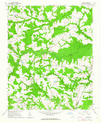
 1963 Red Oak1964 Print · USGSNash County rural life is captured here in the early sixties, showing a landscape of family farms and creek-side communities. Researchers can locate dozens of family burial grounds like Taylor Cem and old church sites including Mt Zion Chapel and Philadelphia Ch.
 - 1963 Map of Essex, 1964 Print
 1963 Essex1964 Print · USGSCoastal plain farmland and tangled creek bottoms define this North Carolina borderland in the early sixties. Genealogists can trace family names at Lynch Cem and Silver Cem, or locate rural landmarks like Aventon and the local Brickyards.2 unique versions available
 - 1963 Map of Drake, 1964 Print
 1963 Drake1964 Print · USGSCoastal Plain farmland and swampy creek bottoms define this Nash County area in the early sixties. Genealogists can trace family names at Dozier Cem and Harper Cem or locate community hubs like Dortches, Drake, and North Carolina Wesleyan College.2 unique versions available
 - 1966 Map of Greensboro
 1966 Greensboro1966 Print · USGSThe North Carolina and Virginia Piedmont thrives during the mid-sixties, showcasing a landscape of textile hubs and expanding river reservoirs. Researchers can trace the rail corridors of the Southern Railway, find local landmarks like Elon College, or locate the extensive Camp Butner Military Reservation.
 - 1968 Map of Zebulon, 1972 Print
 1968 Zebulon1972 Print · USGSThe eastern edges of Wake County meet Franklin and Nash in the late sixties, where small-town industry revolves around the rail lines. Local historians can trace family ties at St. Mathews Church or explore the origins of Lizard Lick and Wakefield.3 unique versions available
 - 1975 Map of Rocky Mount, 1978 Print
 1975 Rocky Mount1978 Print · USGSRocky Mount and the surrounding Nash County countryside are captured in this mid-1970s aerial survey. Local historians and genealogists can trace the footprint of the city alongside nearby settlements like Sharpsburg and Battleboro as they appeared decades ago.
 - 1977 Map of Nashville
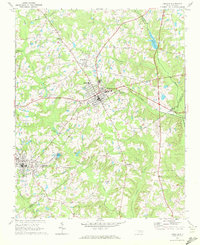
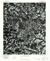
 1977 Nashville1977 Print · USGSNash County in the late seventies is centered on the growing town of Nashville, where rail lines and regional schools meet the surrounding farmland. Researchers can trace rural lineages through numerous country churches and cemeteries, such as Taylors Chapel, Sapony Ch, and Oakland Cem.
 - 1977 Map of Rocky Mount
 1977 Rocky Mount1977 Print · USGSRocky Mount is captured in the late seventies as it expanded across the Nash and Edgecombe county lines. Researchers can trace neighborhood growth through Woodlawn and Sunset or locate local landmarks like Buck Leonard Park and the Drive-in Theater.
Showing maps 1-25 of 140
Top cities of Nash County
- Nashville historical maps
- Red Oak historical maps
- Spring Hope historical maps
- Middlesex historical maps
- Dortches historical maps
- Bailey historical maps
See more
Frequently asked questions
- What are the different types of historical maps available for Nash County?
- What is the oldest map of Nash County?
- Where can I purchase historical maps of Nash County for my home or office?
- Where can I download high-res historical maps of Nash County?
- Are there historical topographic maps available for Nash County?
- Is there historical aerial imagery available for Nash County?
- Where are historical maps of Nash County sourced from?