1940s Maps of Onslow County, North Carolina
Explore 11 historic maps of Onslow County from the 1940s. These maps offer a rare glimpse into what life looked like during the 1940s — showing old roads, neighborhoods, homes, and landmarks that have changed or disappeared over time.
Whether you're researching your family's past, planning a metal detecting trip, or studying how Onslow County's landscape evolved across the 1940s, these high-resolution maps are a powerful tool for exploring the history of this region.
- Focus on a specific era: All maps on this page are from the 1940s, giving you a focused view of this time period.
- See what’s changed: Compare century-old streets, trails, and buildings to today's modern landscape using overlays and satellite layers.
- Research with precision: Use these maps for genealogy, historical research, land use analysis, or educational projects.
- View, download, or print: Maps are fully viewable online in high resolution, and can be downloaded or printed for your own records.
Start exploring Onslow County's history through authentic maps from the 1940s. This is your window into the past.
Onslow County, NC maps
(11)- 1942 Map of Spicer Bay
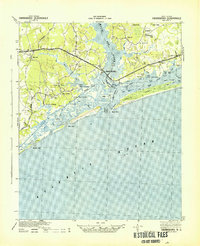
 1942 Spicer Bay1942 Print · USGSCoastal Onslow County is shown during the early 1940s, mapping the intricate tidal system before the onset of modern beach development. Researchers can trace the original path of the Inland Waterway and locate old landmarks like Thomas Landing and Hobbs Point.
 - 1942 Map of Topsail
 1942 Topsail1942 Print · USGSThe Pender County coast was undergoing a military transformation in the early 1940s as infrastructure expanded around Camp Davis. Genealogists and historians can trace dozens of family-named water access points like Howard Landing and Edens Landing along the edge of Topsail Sound.
 - 1942 Map of Maysville
 1942 Maysville1942 Print · USGSCoastal North Carolina during the early years of the war is captured here through its networks of swamp forests and river settlements. Genealogists and local historians can trace the rural landscape through White Oak Sch, the Hadnot Ch, and rail stops along the Atlantic Coast Line Railroad.
 - 1942 Map of Swansboro
 1942 Swansboro1942 Print · USGSThe North Carolina coast during the early 1940s reveals a world of intricate waterways and family-named landings before mid-century development. Genealogists and historians can trace old sites like Snead Ferry, Willis Landing, and the inland hub of Whitehouse Forks.
 - 1943 Map of Jacksonville
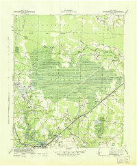 1943 Jacksonville1943 Print · USGSThe Onslow County coastal plain at the height of the Second World War shows a landscape defined by timberlands and the growing importance of Jacksonville. Genealogists can locate family landmarks at Sabiston Crossing, rural communities like Pumpkin Center, and the route of the Atlantic Coast Line Railroad.
 - 1948 Map of Maysville
 1948 Maysville1948 Print · USGSCoastal North Carolina's river-fed lowlands come to life in this late-forties survey of the Jones and Onslow county borderlands. Genealogists and local historians can trace the rural landscape from Polloksville down to Stella, locating landmarks like Tabernacle Sch and Lees Ch.
 - 1948 Map of Maple Hill
 1948 Maple Hill1948 Print · USGSSoutheastern North Carolina is mapped here just after the war, showing the deep swamp landscapes of the coastal plain. Genealogists and researchers can trace the roads connecting Maple Hill to Camp Davis and locate rural landmarks like Waltons Store.2 unique versions available
 - 1948 Map of Swansboro
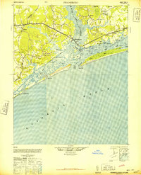 1948 Swansboro1948 Print · USGSCoastal North Carolina's maritime character is preserved here in the late 1940s, centered on the historic waterfront at Swansboro. Researchers can trace the legacy of tidal commerce through numerous family-named sites like Willis Landing and Great Neck Landing.
 - 1948 Map of Topsail
 1948 Topsail1948 Print · USGSThe Pender County coastline is shown here in the late 1940s, when the maritime economy was centered on small inlets and landings. Researchers can trace the military history of Camp Davis or locate family sites at Edens Landing and Hampstead.2 unique versions available
 - 1948 Map of New River
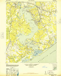 1948 New River1948 Print · USGSCoastal Onslow County underwent a massive transformation just after the war as the Marine Corps expanded its footprint along the New River. Researchers can trace early military infrastructure at the Peters Point Field Glider Base alongside civilian landmarks like Sneads Ferry and Mumfords Mill.2 unique versions available
 - 1948 Map of Richlands
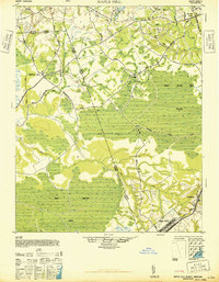
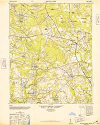 1948 Richlands1948 Print · USGSCoastal North Carolina's rural landscape comes alive in this post-war study of the Onslow and Duplin county borderlands. Genealogists and historians can trace family-named sites like Huffmantown, Potters Hill, and distinctive terrain like Hell Pocosin.2 unique versions available
End of results
Showing maps 1-11 of 11
Top cities of Onslow County
- Jacksonville historical maps
- Half Moon historical maps
- Swansboro historical maps
- Sneads Ferry historical maps
- Richlands historical maps
- Holly Ridge historical maps
See more
Frequently asked questions
- What are the different types of historical maps available for Onslow County?
- What is the oldest map of Onslow County?
- Where can I purchase historical maps of Onslow County for my home or office?
- Where can I download high-res historical maps of Onslow County?
- Are there historical topographic maps available for Onslow County?
- Is there historical aerial imagery available for Onslow County?
- Where are historical maps of Onslow County sourced from?