1950s Maps of Onslow County, North Carolina
Explore 10 historic maps of Onslow County from the 1950s. These maps offer a rare glimpse into what life looked like during the 1950s — showing old roads, neighborhoods, homes, and landmarks that have changed or disappeared over time.
Whether you're researching your family's past, planning a metal detecting trip, or studying how Onslow County's landscape evolved across the 1950s, these high-resolution maps are a powerful tool for exploring the history of this region.
- Focus on a specific era: All maps on this page are from the 1950s, giving you a focused view of this time period.
- See what’s changed: Compare century-old streets, trails, and buildings to today's modern landscape using overlays and satellite layers.
- Research with precision: Use these maps for genealogy, historical research, land use analysis, or educational projects.
- View, download, or print: Maps are fully viewable online in high resolution, and can be downloaded or printed for your own records.
Start exploring Onslow County's history through authentic maps from the 1950s. This is your window into the past.
Onslow County, NC maps
(10)- 1952 Map of Hubert, 1954 Print
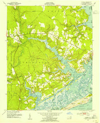 1952 Hubert1954 Print · USGSThe Onslow County coast appears in the early fifties as a landscape of military reservations and tide-water settlements. Trace old family sites and maritime routes near Swansboro, Piney Grove Ch, and the many docks at Shell Rock Landing.3 unique versions available
 - 1952 Map of Camp Lejeune, 1954 Print
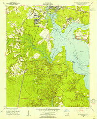
 1952 Camp Lejeune1954 Print · USGSCoastal Onslow County is seen here during the mid-century expansion of the Camp Lejeune Military Reservation. Local historians can trace established communities like Piney Green and Kelluntown alongside early base housing at Midway Park.4 unique versions available
 - 1952 Map of Swansboro, 1954 Print
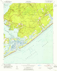
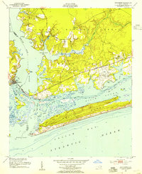 1952 Swansboro1954 Print · USGSCoastal North Carolina at the midpoint of the century reveals a landscape defined by its waterways and a growing military footprint. Genealogists and historians can trace family locations near Swansboro, locate the Bogue Sch, or study the layout of Bogue Airfield and the Coast Guard Station.4 unique versions available
 - 1952 Map of Jacksonville South, 1954 Print
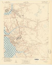
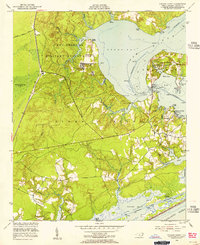
 1952 Jacksonville South1954 Print · USGSCoastal Onslow County is seen here during the post-war expansion of military and civilian infrastructure along the New River. Genealogists and historians can locate Verona, the Georgetown High Sch, and the Peters Point Field Glider Base.4 unique versions available
 - 1952 Map of Browns Inlet, 1955 Print
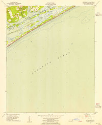
 1952 Browns Inlet1955 Print · USGSCoastal North Carolina was defined by military training grounds and intricate tidal sounds during the early fifties. Genealogists and maritime historians can trace the paths of the Intracoastal Waterway and name local features like Saunders Island and Shackelfoot Channel.5 unique versions available
 - 1952 Map of Spicer Bay, 1955 Print
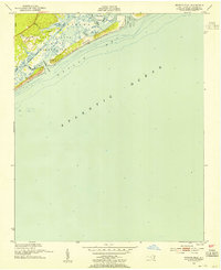
 1952 Spicer Bay1955 Print · USGSThe Onslow County coast in the early fifties shows a landscape of tidal marshes and quiet landings before the era of modern beach development. Maritime researchers and local historians can trace the Intracoastal Waterway past Tar Landing, Ashe Island, and the coastal markers of Tower Six.3 unique versions available
 - 1952 Map of New River Inlet, 1955 Print
 1952 New River Inlet1955 Print · USGSCoastal Onslow County is shown in the early fifties during the expansion of the Camp Lejeune Military Reservation. Researchers can trace the mid-century shoreline from New River Inlet past the old settlement at Peru and the docks of Courthouse Bay.4 unique versions available
 - 1952 Map of Sneads Ferry, 1955 Print
 1952 Sneads Ferry1955 Print · USGSThe Onslow County coastline comes alive in this mid-century survey, capturing the maritime character of the Sneads Ferry area before modern development. Genealogists can trace old family sites and rural landmarks like Little Zion Ch, Carrels Chapel, and the river landings at Fulcher and Sandford Landing.5 unique versions available
 - 1953 Map of Beaufort, 1965 Print
 1953 Beaufort1965 Print · USGSThe North Carolina coastline in the mid-fifties reveals an era of massive military expansion alongside traditional maritime life. Genealogists can trace family names and small settlements from Sealevel to Sneads Ferry or locate landmarks like Fort Macon.3 unique versions available
 - 1954 Map of Beaufort
 1954 Beaufort1954 Print · USGSCoastal North Carolina in the mid-fifties reveals a landscape of strategic military installations, sprawling wetlands, and thriving rail towns. Genealogists and historians can trace the foundations of Wilmington, the rural reaches of Duplin County, and shoreline landmarks like Cape Lookout and Carolina Beach.
End of results
Showing maps 1-10 of 10
Top cities of Onslow County
- Jacksonville historical maps
- Half Moon historical maps
- Swansboro historical maps
- Sneads Ferry historical maps
- Richlands historical maps
- Holly Ridge historical maps
See more
Frequently asked questions
- What are the different types of historical maps available for Onslow County?
- What is the oldest map of Onslow County?
- Where can I purchase historical maps of Onslow County for my home or office?
- Where can I download high-res historical maps of Onslow County?
- Are there historical topographic maps available for Onslow County?
- Is there historical aerial imagery available for Onslow County?
- Where are historical maps of Onslow County sourced from?