1990s Maps of Onslow County, North Carolina
Explore 17 historic maps of Onslow County from the 1990s. These maps offer a rare glimpse into what life looked like during the 1990s — showing old roads, neighborhoods, homes, and landmarks that have changed or disappeared over time.
Whether you're researching your family's past, planning a metal detecting trip, or studying how Onslow County's landscape evolved across the 1990s, these high-resolution maps are a powerful tool for exploring the history of this region.
- Focus on a specific era: All maps on this page are from the 1990s, giving you a focused view of this time period.
- See what’s changed: Compare century-old streets, trails, and buildings to today's modern landscape using overlays and satellite layers.
- Research with precision: Use these maps for genealogy, historical research, land use analysis, or educational projects.
- View, download, or print: Maps are fully viewable online in high resolution, and can be downloaded or printed for your own records.
Start exploring Onslow County's history through authentic maps from the 1990s. This is your window into the past.
Onslow County, NC maps
(17)- 1990 Map of Wilmington
 1990 Wilmington1990 Print · USGSThe North Carolina coast in the early nineties reveals a landscape defined by the convergence of the Cape Fear River and the Atlantic shore. Genealogists and historians can trace suburban growth and maritime infrastructure from the inland Kendall Chapel to coastal hubs like Wrightsville Beach and Carolina Beach.
 - 1991 Map of New River
 1991 New River1991 Print · USGSCoastal Onslow and Pender counties appear here in the early 1990s as the military and maritime economies matured. Researchers can trace the expansive Camp Lejeune grounds and find rural landings like Fulcher Landing and Sanders Landing.
 - 1994 Map of Maysville, 1997 Print
 1994 Maysville1997 Print · USGSThe coastal plains of eastern North Carolina meet the deep swamps of the Croatan National Forest in the 1990s. Genealogists and local historians can trace family locations near Temple Zions Chapel, Lees Methodist Chapel, and the historic banks of the White Oak River.2 unique versions available
 - 1994 Map of Stella, 1997 Print
 1994 Stella1997 Print · USGSThe White Oak River basin comes to life in the mid-nineties as it winds past the coastal forest and rural settlements. Genealogists can trace family roots through the Silverdale School, Tabernacle Ch, and the riverside community of Stella.2 unique versions available
 - 1994 Map of Swansboro, 1997 Print
 1994 Swansboro1997 Print · USGSThe Onslow and Carteret County coasts met in the mid-nineties amidst a landscape of protected wilderness and growing soundside communities. Researchers can trace the layout of Swansboro, the Bogue Airfield, and the dunes of Bear Island.
 - 1994 Map of Hadnot Creek, 1997 Print
 1994 Hadnot Creek1997 Print · USGSCoastal North Carolina wetlands and military grounds are captured in the mid-nineties, showing the intersection of the Croatan National Forest and Camp Lejeune. Genealogists and local historians can locate Hadnot Ch and traces of family cemeteries near the White Oak River.2 unique versions available
 - 1997 Map of Holly Ridge, 1999 Print
 1997 Holly Ridge1999 Print · USGSCoastal North Carolina during the late nineties shows a landscape of barrier island growth and protected inland wetlands. Genealogists can trace family connections through numerous landings like Edens Landing and rural churches such as Stump Sound Ch.
 - 1997 Map of Browns Inlet, 1999 Print
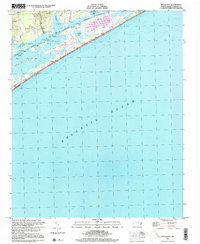
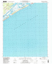 1997 Browns Inlet1999 Print · USGSThe Onslow County coast at the close of the century shows a unique intersection of military training grounds and preserved beach wilderness. Researchers can trace the shifting sands and tidal reaches of Browns Inlet and Bear Island or locate markers along the Intracoastal Waterway.
 - 1997 Map of New River Inlet, 1999 Print
 1997 New River Inlet1999 Print · USGSThe North Carolina coast at the edge of the military reservation shows a intricate network of waterways in the late nineties. Trace the legacy of coastal settlements like Marines and Peru, or locate family landmarks such as Swan Pt and Wilkins Bluff.
 - 1997 Map of Jacksonville NW, 2000 Print
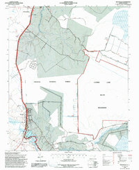
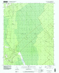 1997 Jacksonville NW2000 Print · USGSOnslow County's timberlands and wetlands are preserved here as they appeared in the late nineties, showcasing the intersection of the Hofmann Forest and White Oak Pocosin. Researchers can trace the watercourses of Little Cypress Creek and find the rural St Louis Ch at the forest's edge.
 - 1997 Map of Jacksonville South, 2000 Print
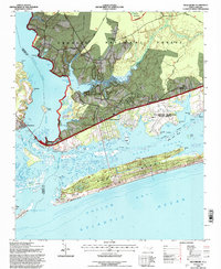
 1997 Jacksonville South2000 Print · USGSThe Jacksonville waterfront and the northern reaches of Camp Lejeune are captured here in the late 1990s. Researchers can trace the layout of New River MCAS, explore the small community of Verona, and locate local landmarks like Georgetown High Sch.
 - 1997 Map of Jacksonville NE, 2000 Print
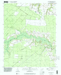 1997 Jacksonville NE2000 Print · USGSCoastal North Carolina's boggy lowlands are preserved here in the late nineties, where the Hofmann Forest meets the winding White Oak River. Researchers can trace the water network from Little Hell Creek to Gibson Bridge, alongside local landmarks like White Oak Ch.
 - 1997 Map of Kellum, 2000 Print
 1997 Kellum2000 Print · USGSCoastal Onslow County in the late nineties shows the expansion of residential life near the edge of the great White Oak Pocosin. Researchers can locate several rural cemeteries, the White Oak Airport, and old crossroads like Kellum and Pumpkin Center.
 - 1997 Map of Hubert, 2000 Print
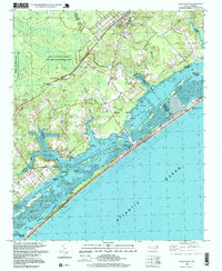
 1997 Hubert2000 Print · USGSCoastal Onslow County at the close of the nineties shows a landscape defined by maritime heritage and military presence. Researchers can trace the boundaries of Camp Lejeune and locate local landmarks like Oak Grove Ch and Swansboro.
 - 1997 Map of Jacksonville North, 2000 Print
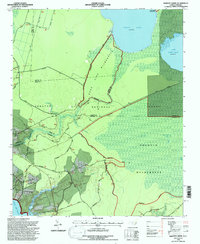
 1997 Jacksonville North2000 Print · USGSJacksonville and Onslow County are captured during a period of rapid northward expansion in the late nineties. Genealogists and local historians can trace the evolution of communities like Gum Branch and Tar Landing alongside landmarks like Bethlehem Ch and Onslow Memorial Hospital.
 - 1997 Map of Spicer Bay, 2000 Print
 1997 Spicer Bay2000 Print · USGSThe Onslow County coast at the end of the century is a labyrinth of tidal sounds and barrier islands. Researchers can trace waterfront settlements like Thomas Landing and Hobbs or explore the maritime geography of Stump Sound and Ashe Island.
 - 1997 Map of Sneads Ferry, 2000 Print
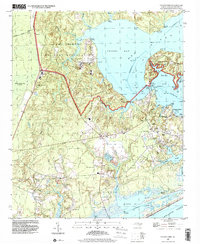 1997 Sneads Ferry2000 Print · USGSCoastal Onslow County at the close of the twentieth century shows a landscape shared by the Camp Lejeune Military Reservation and the historic fishing village of Sneads Ferry. Genealogists and local historians can trace family roots through landmarks like Little Zion Ch, Yopps Ch, and old waterfront spots like Sandford Landing.
End of results
Showing maps 1-17 of 17
Top cities of Onslow County
- Jacksonville historical maps
- Half Moon historical maps
- Swansboro historical maps
- Sneads Ferry historical maps
- Richlands historical maps
- Holly Ridge historical maps
See more
Frequently asked questions
- What are the different types of historical maps available for Onslow County?
- What is the oldest map of Onslow County?
- Where can I purchase historical maps of Onslow County for my home or office?
- Where can I download high-res historical maps of Onslow County?
- Are there historical topographic maps available for Onslow County?
- Is there historical aerial imagery available for Onslow County?
- Where are historical maps of Onslow County sourced from?