1970s Maps of Onslow County, North Carolina
Explore 6 historic maps of Onslow County from the 1970s. These maps offer a rare glimpse into what life looked like during the 1970s — showing old roads, neighborhoods, homes, and landmarks that have changed or disappeared over time.
Whether you're researching your family's past, planning a metal detecting trip, or studying how Onslow County's landscape evolved across the 1970s, these high-resolution maps are a powerful tool for exploring the history of this region.
- Focus on a specific era: All maps on this page are from the 1970s, giving you a focused view of this time period.
- See what’s changed: Compare century-old streets, trails, and buildings to today's modern landscape using overlays and satellite layers.
- Research with precision: Use these maps for genealogy, historical research, land use analysis, or educational projects.
- View, download, or print: Maps are fully viewable online in high resolution, and can be downloaded or printed for your own records.
Start exploring Onslow County's history through authentic maps from the 1970s. This is your window into the past.
Onslow County, NC maps
(6)- 1970 Map of Holly Ridge, 1973 Print
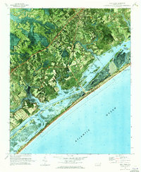 1970 Holly Ridge1973 Print · USGSCoastal Onslow and Pender counties come to life in this early 1970s orthophotomap showing the transition from forest to shore. Researchers can trace family landings like Morris Landing and Sears Landing or study the early layouts of Surf City and Topsail Beach.
 - 1972 Map of Beaufort, 1975 Print
 1972 Beaufort1975 Print · USGSThe North Carolina coast in the early seventies shows a landscape defined by massive military bases and coastal sounds. Trace rural family roots at Sarecta and Catherine Lake or explore the barrier islands of the Cape Lookout National Seashore.
 - 1975 Map of Jacksonville NW, 1977 Print
 1975 Jacksonville NW1977 Print · USGSCoastal Onslow and Jones counties in the mid-seventies are defined by the dense timberlands of the Hofmann Forest. Genealogists and historians can trace the rural landscape near St Louis Ch and the watery reaches of Juniper Swamp and Bear Prong.
 - 1977 Map of Kellum
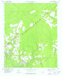 1977 Kellum1977 Print · USGSCoastal Onslow County in the late seventies is shown as a mix of managed timberlands and emerging suburban pockets. Genealogists and local historians can locate many rural cemeteries and community landmarks like White Oak High School and Kellum.2 unique versions available
 - 1978 Map of Jacksonville NE
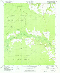 1978 Jacksonville NE1978 Print · USGSThe Jones and Onslow county line meandered through the timberlands of the White Oak Pocosin in the late 1970s. Researchers can trace old family sites and transport routes like White Oak Ch, the Old RR Grade, and small Cem locations.
 - 1978 Map of Jacksonville North
 1978 Jacksonville North1978 Print · USGSJacksonville and the New River valley were entering a period of significant growth in the late seventies. Researchers can trace the expansion of neighborhoods like Northwoods Park and Hawkside or locate rural landmarks such as Bethlehem Ch and Tar Landing.
End of results
Showing maps 1-6 of 6
Top cities of Onslow County
- Jacksonville historical maps
- Half Moon historical maps
- Swansboro historical maps
- Sneads Ferry historical maps
- Richlands historical maps
- Holly Ridge historical maps
See more
Frequently asked questions
- What are the different types of historical maps available for Onslow County?
- What is the oldest map of Onslow County?
- Where can I purchase historical maps of Onslow County for my home or office?
- Where can I download high-res historical maps of Onslow County?
- Are there historical topographic maps available for Onslow County?
- Is there historical aerial imagery available for Onslow County?
- Where are historical maps of Onslow County sourced from?