1950s Maps of Pender County, North Carolina
Explore 9 historic maps of Pender County from the 1950s. These maps offer a rare glimpse into what life looked like during the 1950s — showing old roads, neighborhoods, homes, and landmarks that have changed or disappeared over time.
Whether you're researching your family's past, planning a metal detecting trip, or studying how Pender County's landscape evolved across the 1950s, these high-resolution maps are a powerful tool for exploring the history of this region.
- Focus on a specific era: All maps on this page are from the 1950s, giving you a focused view of this time period.
- See what’s changed: Compare century-old streets, trails, and buildings to today's modern landscape using overlays and satellite layers.
- Research with precision: Use these maps for genealogy, historical research, land use analysis, or educational projects.
- View, download, or print: Maps are fully viewable online in high resolution, and can be downloaded or printed for your own records.
Start exploring Pender County's history through authentic maps from the 1950s. This is your window into the past.
Pender County, NC maps
(9)- 1952 Map of Spicer Bay, 1955 Print
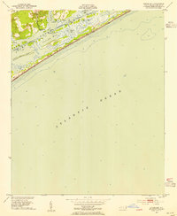 1952 Spicer Bay1955 Print · USGSThe Onslow County coast in the early fifties shows a landscape of tidal marshes and quiet landings before the era of modern beach development. Maritime researchers and local historians can trace the Intracoastal Waterway past Tar Landing, Ashe Island, and the coastal markers of Tower Six.3 unique versions available
 - 1953 Map of Florence, 1964 Print
 1953 Florence1964 Print · USGSThe Carolina borderlands in the mid-fifties were a landscape of vast river swamps and rising rail towns. Trace the legacy of the Seaboard Air Line through Florence or explore the wetlands surrounding Lake Waccamaw and the Green Swamp.3 unique versions available
 - 1953 Map of Beaufort, 1965 Print
 1953 Beaufort1965 Print · USGSThe North Carolina coastline in the mid-fifties reveals an era of massive military expansion alongside traditional maritime life. Genealogists can trace family names and small settlements from Sealevel to Sneads Ferry or locate landmarks like Fort Macon.3 unique versions available
 - 1954 Map of Florence
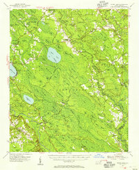
 1954 Florence1954 Print · USGSThe Carolinas borderlands come alive in the early fifties, showing the vital rail-and-river networks of the coastal plain. Genealogists can trace family footprints across the Green Swamp or through settlements like Red Springs, Chadbourn, and McColl.
 - 1954 Map of Beaufort
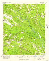
 1954 Beaufort1954 Print · USGSCoastal North Carolina in the mid-fifties reveals a landscape of strategic military installations, sprawling wetlands, and thriving rail towns. Genealogists and historians can trace the foundations of Wilmington, the rural reaches of Duplin County, and shoreline landmarks like Cape Lookout and Carolina Beach.
 - 1954 Map of White Lake, 1956 Print
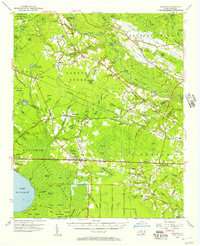
 1954 White Lake1956 Print · USGSCoastal Bladen and Sampson counties are shown here in the mid-fifties, dominated by the unique elliptical depressions of the Carolina Bays. Family researchers can locate remote landmarks like Kates Chapel Cem, Smith Crossroads, and the various landings along the Cape Fear River.
 - 1954 Map of Acme, 1957 Print
 1954 Acme1957 Print · USGSCoastal North Carolina river life in the mid-fifties centered on the confluence of the Cape Fear and the Black River. Genealogists can trace family names at Still Bluff and Maultbys Point, or locate the historic Lincoln High Sch and Farmers Chapel.2 unique versions available
 - 1954 Map of Bolton, 1957 Print
 1954 Bolton1957 Print · USGSCoastal North Carolina's timber and rail corridor is captured here in the mid-fifties, spanning the rugged terrain between the Cape Fear River and Green Swamp. Researchers can trace old family sites and rural congregations at Weyman Chapel, New Hope Ch, and the settlement of Wananish.2 unique versions available
 - 1955 Map of Atkinson, 1957 Print
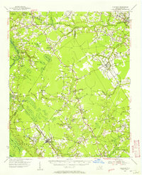 1955 Atkinson1957 Print · USGSCoastal plain life in the mid-1950s revolves around the timberlands and rail-stops between the Black River and Moores Creek. Genealogists and historians can trace family ties through dozens of rural landmarks like Newtons Crossroads, St. Marys Ch, and Bland High Sch.2 unique versions available
End of results
Showing maps 1-9 of 9
Top cities of Pender County
- Burgaw historical maps
- Surf City historical maps
- Topsail Beach historical maps
- Atkinson historical maps
- Watha historical maps
- Hampstead historical maps
Frequently asked questions
- What are the different types of historical maps available for Pender County?
- What is the oldest map of Pender County?
- Where can I purchase historical maps of Pender County for my home or office?
- Where can I download high-res historical maps of Pender County?
- Are there historical topographic maps available for Pender County?
- Is there historical aerial imagery available for Pender County?
- Where are historical maps of Pender County sourced from?