1980s Maps of Pender County, North Carolina
Explore 33 historic maps of Pender County from the 1980s. These maps offer a rare glimpse into what life looked like during the 1980s — showing old roads, neighborhoods, homes, and landmarks that have changed or disappeared over time.
Whether you're researching your family's past, planning a metal detecting trip, or studying how Pender County's landscape evolved across the 1980s, these high-resolution maps are a powerful tool for exploring the history of this region.
- Focus on a specific era: All maps on this page are from the 1980s, giving you a focused view of this time period.
- See what’s changed: Compare century-old streets, trails, and buildings to today's modern landscape using overlays and satellite layers.
- Research with precision: Use these maps for genealogy, historical research, land use analysis, or educational projects.
- View, download, or print: Maps are fully viewable online in high resolution, and can be downloaded or printed for your own records.
Start exploring Pender County's history through authentic maps from the 1980s. This is your window into the past.
Pender County, NC maps
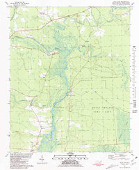
(33)- 1980 Map of Rocky Point, 1985 Print
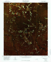
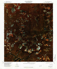 1980 Rocky Point1985 Print · USGSCoastal Pender County is shown in detail during the early eighties as agricultural fields and timberlands surrounded the river. Researchers can trace rural family sites and river landings including Rocky Point, Bells Crossroads, and Clarks Landing.
 - 1980 Map of Castle Hayne, 1985 Print
 1980 Castle Hayne1985 Print · USGSThe coastal plains north of Wilmington are revealed in this 1980 infrared survey, showing the expansion of rural communities into the surrounding timberlands. Trace the winding Northeast Cape Fear River and the early footprints of Castle Hayne and Wrightsboro.2 unique versions available
 - 1980 Map of Mooretown, 1985 Print
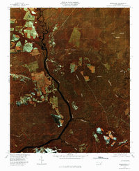 1980 Mooretown1985 Print · USGSPender County in the early eighties is captured here in a transition between its agricultural roots and the wild wetlands of the Holly Shelter Bay. Researchers can trace the riverfront near Mooretown and locate creek crossings at Pike Creek and Merricks Creek.2 unique versions available
 - 1980 Map of Acme, 1985 Print
 1980 Acme1985 Print · USGSCoastal North Carolina industrial and rail corridors are captured in this early 1980s infrared survey of the lower Cape Fear region. Researchers can trace the development of Riegelwood and the historic railway hamlets of Delco, Acme, and Maco.
 - 1980 Map of Leland, 1985 Print
 1980 Leland1985 Print · USGSCoastal Brunswick County is captured in the early eighties as its riverfront towns began to expand near the Cape Fear. Genealogists and local historians can locate early settlements like Phoenix and Malmo or trace the winding course of Hood Creek.
 - 1980 Map of Topsail, 1985 Print
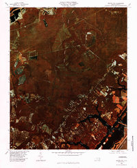
 1980 Topsail1985 Print · USGSThe North Carolina coast at the dawn of the eighties reveals a sharp divide between the massive Holly Shelter Swamp and burgeoning shoreward communities. Trace the early footprints of Topsail and Woodside as they expand toward the waters of Topsail Sound.2 unique versions available
 - 1980 Map of Point Caswell, 1985 Print
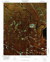
 1980 Point Caswell1985 Print · USGSThe riverine landscapes of Pender County are captured in this color infrared aerial survey from the early 1980s. Local researchers can trace family lands and rural property boundaries near Point Caswell, Long View, and the winding banks of the Black River.
 - 1980 Map of Currie, 1985 Print
 1980 Currie1985 Print · USGSCoastal Pender County reveals its intricate riverine character in the early 1980s as agricultural clearings push against dense swampland. Genealogists and local historians can trace the rural layouts of Currie, Montague, and the banks of the Black River.
 - 1980 Map of Holly Ridge, 1985 Print
 1980 Holly Ridge1985 Print · USGSThe Onslow County coast in the early eighties shows the rhythmic patterns of barrier island life and inland timbering. Genealogists and historians can locate old coastal sites like Morris Landing and Watts Landing along Topsail Sound.
 - 1980 Map of Scotts Hill, 1985 Print
 1980 Scotts Hill1985 Print · USGSCoastal New Hanover County is frozen in time during the early eighties, showing the region's transition from rural timberland to developing neighborhoods. Researchers can trace the winding paths of Pages Creek and Howe Creek or locate early layouts of Murraysville and Scotts Hill.
 - 1980 Map of Spicer Bay, 1985 Print
 1980 Spicer Bay1985 Print · USGSThe North Carolina coast in the early eighties appears in sharp infrared detail, showing the tidal marshlands of Onslow County. Researchers can trace the shoreline of Stump Sound and locate landings like Thomas Landing and the reaches of Spicer Bay.2 unique versions available
 - 1980 Map of Hampstead, 1986 Print
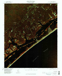
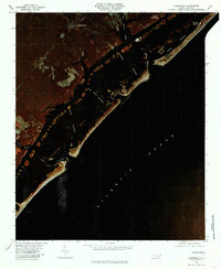 1980 Hampstead1986 Print · USGSThe Pender County coastline and barrier islands are seen here in the early eighties as residential development began to expand around Hampstead. Genealogists and historians can trace the inland settlements of Browntown and the coastal landing at Kings Landing.
 - 1981 Map of Wallace East
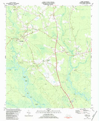
 1981 Wallace East1981 Print · USGSCoastal North Carolina's river and rail corridor is captured here in the early eighties as the Seaboard Coast Line connects small towns. Researchers can trace family roots through the rural settlements of Willard, Watha, and Tin City, or locate the Riverview Memorial Park (Cemetery) near the riverbanks.
 - 1981 Map of Stag Park
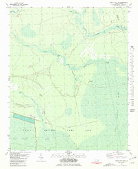
 1981 Stag Park1981 Print · USGSCoastal Pender County in the early eighties is defined by the winding Northeast Cape Fear River and its dense bottomlands. Genealogists can trace small riverfront settlements and rural landmarks like White Stocking, Kings Ch, and Walkers Store.2 unique versions available
 - 1981 Map of Maple Hill
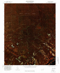
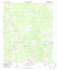
 1981 Maple Hill1981 Print · USGSIn the early 1980s, the crossroads at Maple Hill remained the heart of this three-county borderland. Local historians can trace the foundations of the community through its schools and churches like Pilgrims Rest Ch and the remote Angola Ch.
 - 1981 Map of Folkstone
 1981 Folkstone1981 Print · USGSCoastal Onslow County is shown here in the early eighties as a landscape shaped by vast wetlands and the railroad. Genealogists and local historians can trace the Seaboard Coast Line through Folkstone or locate an Abandoned Landing Strip near Holly Ridge.2 unique versions available
 - 1981 Map of Maple Hill SW
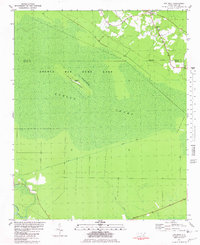
 1981 Maple Hill SW1981 Print · USGSCoastal Pender and Onslow counties are captured in the early eighties, showcasing a wild landscape defined by the Holly Shelter Swamp. You can trace primitive access routes like Lodge Road through a terrain of isolated rises including Pine Island and Bryants Ridge.
 - 1981 Map of Pin Hook
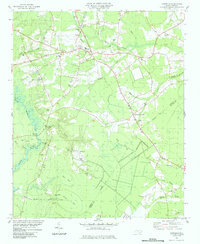
 1981 Pin Hook1981 Print · USGSCoastal North Carolina wetlands define this early 1980s landscape at the Pender and Duplin county line. Genealogists and local historians can locate Pin Hook, trace the path of Convict Road, and find rural landmarks like Oak Grove Ch.
 - 1981 Map of Burgaw
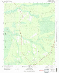
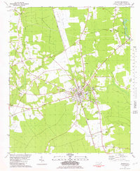 1981 Burgaw1981 Print · USGSThe Pender County seat of Burgaw and its surrounding coastal plains are shown here in the early eighties as the rail-and-river economy persisted. Genealogists can locate family landmarks such as Murray Town, James Hopewell Ch, and the settlement of Van Eden.2 unique versions available
 - 1982 Map of Elizabethtown, 1983 Print
 1982 Elizabethtown1983 Print · USGSSoutheastern North Carolina's coastal plain is captured here in the early eighties, showcasing a landscape defined by the Cape Fear River and mysterious Carolina Bays. Genealogists and researchers can trace the rail network of the Seaboard Coast Line through rural communities like Autryville, Ivanhoe, and the recreational hub of White Lake.
 - 1983 Map of Point Caswell, 1984 Print
 1983 Point Caswell1984 Print · USGSThe river-and-swamp country of Pender and Bladen Counties is captured here in the early 1980s. Genealogists can trace family landmarks like Haw Bluff Ch, Rosa Green Ch, and the Moore Cem along the winding BLACK RIVER.
 - 1983 Map of Currie, 1984 Print
 1983 Currie1984 Print · USGSCoastal Pender County in the early eighties centers on the Revolutionary War site at Moores Creek Nat Battlefield. Genealogists and historians can trace numerous family cemeteries and rural landmarks like Long Creek Grady Sch and Myrtle Grove Ch.2 unique versions available
 - 1984 Map of Harrells
 1984 Harrells1984 Print · USGSSampson County settlement patterns in the early eighties are anchored by the rural community of Harrells. Genealogists and historians can trace family roots through numerous sites like Iron Mine Burial Park, Bland Sch, and the Melvin Cem.
 - 1984 Map of Acme
 1984 Acme1984 Print · USGSCoastal North Carolina settlements at the confluence of three counties are captured here in the early eighties. Genealogists and local historians can trace family roots through numerous landmarks like Sykes Cemetery, Farmers Chapel, and the Acme-Delco School.
 - 1984 Map of Costin
 1984 Costin1984 Print · USGSPender County's rural interior during the early eighties is captured here, showing a landscape of timbered lowlands and crossroads hamlets. Genealogists and researchers can trace local family landmarks from Wards Corner to Costin, including Walker Cem and Shiloh Ch.
Showing maps 1-25 of 33
Top cities of Pender County
- Burgaw historical maps
- Surf City historical maps
- Topsail Beach historical maps
- Atkinson historical maps
- Watha historical maps
- Hampstead historical maps
Frequently asked questions
- What are the different types of historical maps available for Pender County?
- What is the oldest map of Pender County?
- Where can I purchase historical maps of Pender County for my home or office?
- Where can I download high-res historical maps of Pender County?
- Are there historical topographic maps available for Pender County?
- Is there historical aerial imagery available for Pender County?
- Where are historical maps of Pender County sourced from?