1980s Maps of Lumberton, North Carolina
Explore 4 historic maps of Lumberton from the 1980s. These maps offer a rare glimpse into what life looked like during the 1980s — showing old roads, neighborhoods, homes, and landmarks that have changed or disappeared over time.
Whether you're researching your family's past, planning a metal detecting trip, or studying how Lumberton's landscape evolved across the 1980s, these high-resolution maps are a powerful tool for exploring the history of this region.
- Focus on a specific era: All maps on this page are from the 1980s, giving you a focused view of this time period.
- See what’s changed: Compare century-old streets, trails, and buildings to today's modern landscape using overlays and satellite layers.
- Research with precision: Use these maps for genealogy, historical research, land use analysis, or educational projects.
- View, download, or print: Maps are fully viewable online in high resolution, and can be downloaded or printed for your own records.
Start exploring Lumberton's history through authentic maps from the 1980s. This is your window into the past.
Lumberton, NC maps
(4)- 1982 Map of Elizabethtown, 1983 Print
 1982 Elizabethtown1983 Print · USGSSoutheastern North Carolina's coastal plain is captured here in the early eighties, showcasing a landscape defined by the Cape Fear River and mysterious Carolina Bays. Genealogists and researchers can trace the rail network of the Seaboard Coast Line through rural communities like Autryville, Ivanhoe, and the recreational hub of White Lake.
 - 1983 Map of Laurinburg, 1984 Print
 1983 Laurinburg1984 Print · USGSThe Carolina borderlands come into focus in the early 1980s, showcasing a landscape defined by the Sandhills Game Land and major river systems. Genealogists and rail historians can trace the paths of the Seaboard Coast Line Railroad through Hamlet or locate St Andrews College and Cheraw State Park.2 unique versions available
 - 1986 Map of Southeast Lumberton, 1987 Print
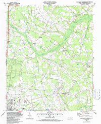
 1986 Southeast Lumberton1987 Print · USGSSoutheast of Lumberton in the mid-1980s, the landscape is a complex puzzle of river bluffs and mysterious Carolina bays. Genealogists and local historians can trace rural communities around Smyrna Ch, Long Branch Sch, and the landings along the Lumber River.
 - 1986 Map of Northeast Lumberton, 1987 Print
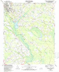
 1986 Northeast Lumberton1987 Print · USGSRobeson County in the mid-1980s shows the expanding footprint of Lumberton alongside its rural roots and Carolina Bay topography. Genealogists and local historians can trace family locations at Thomas Cem and Barkers Ch or explore the area around Robeson Tech Inst.
End of results
Showing maps 1-4 of 4
Top cities near Lumberton
- Fairmont historical maps
- Pembroke historical maps
- Bladenboro historical maps
- Rennert historical maps
- Butters historical maps
- Boardman historical maps
See more
Top neighborhoods of Lumberton
Frequently asked questions
- What are the different types of historical maps available for Lumberton?
- What is the oldest map of Lumberton?
- Where can I purchase historical maps of Lumberton for my home or office?
- Where can I download high-res historical maps of Lumberton?
- Are there historical topographic maps available for Lumberton?
- Is there historical aerial imagery available for Lumberton?
- Where are historical maps of Lumberton sourced from?