1900-1909 Maps of Wayne County, North Carolina
Explore 6 historic maps of Wayne County from 1900-1909. These maps offer a rare glimpse into what life looked like during the 1900s — showing old roads, neighborhoods, homes, and landmarks that have changed or disappeared over time.
Whether you're researching your family's past, planning a metal detecting trip, or studying how Wayne County's landscape evolved across the 1900s, these high-resolution maps are a powerful tool for exploring the history of this region.
- Focus on a specific era: All maps on this page are from the 1900s, giving you a focused view of this time period.
- See what’s changed: Compare century-old streets, trails, and buildings to today's modern landscape using overlays and satellite layers.
- Research with precision: Use these maps for genealogy, historical research, land use analysis, or educational projects.
- View, download, or print: Maps are fully viewable online in high resolution, and can be downloaded or printed for your own records.
Start exploring Wayne County's history through authentic maps from the 1900s. This is your window into the past.
Wayne County, NC maps
(6)- 1902 Map of Kenly
 1902 Kenly1902 Print · USGSCoastal plain settlements in Johnston and Wilson Counties flourished along the rail lines during the early nineteen-hundreds. Genealogists can locate family landmarks like Moores Crossroads and Hares Crossroads or trace the Atlantic Coast Line through Kenly and Micro.2 unique versions available
 - 1903 Map of Kenly
 1903 Kenly1903 Print · USGSCoastal plain settlements and crossroads thrive along the rail corridors of Johnston and Wilson counties at the dawn of the twentieth century. Genealogists can locate family-named sites like Hornes Mill and Barnes Store or trace the early paths through Beulahtown and Kenly.2 unique versions available
 - 1904 Map of Wilson, 1942 Print
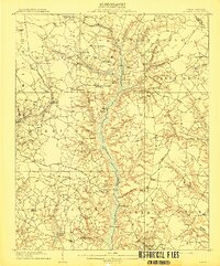
 1904 Wilson1942 Print · USGSCoastal plain settlements and tobacco-country rail lines emerge in this turn-of-the-century look at eastern North Carolina. Genealogists and historians can trace the early footprints of Wilson, Stantonsburg, and Eureka alongside the Atlantic Coast Line railroad.3 unique versions available
 - 1906 Map of Four Oaks
 1906 Four Oaks1906 Print · USGSCoastal plain farming and river commerce define Johnston County at the turn of the century. Genealogists can locate family landmarks like Tarts Store and Bentonville (Beasley PO), alongside historic river crossings at Pierce's Ferry.
 - 1908 Map of Four Oaks
 1908 Four Oaks1908 Print · USGSJohnston County’s agrarian landscape is captured here in the years following the turn of the century, centered on the rail commerce of Four Oaks. Researchers can trace the heritage of local families through landmarks like Peacocks Crossroads, Lees Mill, and Wentworth School.3 unique versions available
 - 1909 Map of Coharie
 1909 Coharie1909 Print · USGSSampson County at the turn of the century is a landscape of creek-side millponds and rural crossroads. Genealogists can trace family roots through numerous local landmarks like Owen Grove Church, Wilsons Store, and Enterprise School.3 unique versions available
End of results
Showing maps 1-6 of 6
Top cities of Wayne County
- Goldsboro historical maps
- Mount Olive historical maps
- Fremont historical maps
- Walnut Creek historical maps
- Pikeville historical maps
- Eureka historical maps
See more
Frequently asked questions
- What are the different types of historical maps available for Wayne County?
- What is the oldest map of Wayne County?
- Where can I purchase historical maps of Wayne County for my home or office?
- Where can I download high-res historical maps of Wayne County?
- Are there historical topographic maps available for Wayne County?
- Is there historical aerial imagery available for Wayne County?
- Where are historical maps of Wayne County sourced from?