1990s Maps of Wayne County, North Carolina
Explore 8 historic maps of Wayne County from the 1990s. These maps offer a rare glimpse into what life looked like during the 1990s — showing old roads, neighborhoods, homes, and landmarks that have changed or disappeared over time.
Whether you're researching your family's past, planning a metal detecting trip, or studying how Wayne County's landscape evolved across the 1990s, these high-resolution maps are a powerful tool for exploring the history of this region.
- Focus on a specific era: All maps on this page are from the 1990s, giving you a focused view of this time period.
- See what’s changed: Compare century-old streets, trails, and buildings to today's modern landscape using overlays and satellite layers.
- Research with precision: Use these maps for genealogy, historical research, land use analysis, or educational projects.
- View, download, or print: Maps are fully viewable online in high resolution, and can be downloaded or printed for your own records.
Start exploring Wayne County's history through authentic maps from the 1990s. This is your window into the past.
Wayne County, NC maps
(8)- 1990 Map of Raleigh, 1991 Print
 1990 Raleigh1991 Print · USGSGreater Raleigh and the Research Triangle entered a period of significant suburban growth during the 1990s. Researchers can trace the development of towns like Fuquay-Varina and Wake Forest or locate landmarks such as the State Prison and Harris Reservoir.2 unique versions available
 - 1997 Map of Newton Grove North, 2000 Print
 1997 Newton Grove North2000 Print · USGSThe rural borderlands of Johnston, Sampson, and Wayne counties are captured here in the late nineties, centered on the significant Bentonville Battleground. Researchers can trace the layout of Newton Grove or locate family-named landmarks and rural congregations like Ebenezer Ch and St John Ch.
 - 1997 Map of Dobbersville, 2000 Print
 1997 Dobbersville2000 Print · USGSThe rural borders of Sampson and Wayne counties come into focus during the late 1990s, showcasing a landscape of isolated farmsteads and swampy lowlands. Researchers can locate numerous small burial sites and historic congregations like Smith Chapel or Wesley Ch near Dobbersville.
 - 1997 Map of Newton Grove South, 2000 Print
 1997 Newton Grove South2000 Print · USGSSampson County settlement patterns are well-defined in the late nineties, centered on the crossroads at Newton Grove. Genealogists can trace family connections through numerous rural landmarks like St Matthew Ch, Hobton, and Marys Chapel.
 - 1998 Map of Northwest Goldsboro, 2001 Print
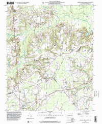
 1998 Northwest Goldsboro2001 Print · USGSWayne County at the close of the century shows a landscape where the Little River meets the Neuse River west of Goldsboro. Researchers can trace historic local institutions and rural community centers like Cherry Hospital, Rosewood, and Spring Hill Ch.
 - 1998 Map of Northeast Goldsboro, 2001 Print
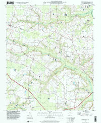
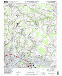 1998 Northeast Goldsboro2001 Print · USGSWayne County saw steady suburban growth in the late nineties as the residential and institutional reach of Goldsboro moved north. Genealogists can trace local roots through landmarks like Pikeville Cem, Parker Chapel, and the historic crossroads at Patetown.
 - 1998 Map of Southeast Goldsboro, 2001 Print
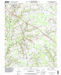
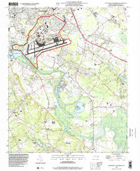 1998 Southeast Goldsboro2001 Print · USGSGoldsboro and its southern environs appear here in the late twentieth century, centered on the massive Seymour Johnson Air Force Base. Researchers can locate numerous country congregations and schools like Daniels Mem Ch, Emmaus Ch, and Meadow Lane Sch.
 - 1998 Map of Southwest Goldsboro, 2001 Print
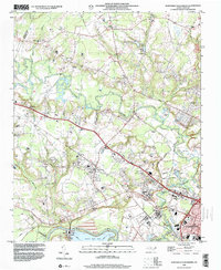
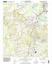 1998 Southwest Goldsboro2001 Print · USGSWayne County comes into focus in the late nineties as residential growth reaches south of the river. Genealogists can trace family names at Stevens Mill and Overman, or find local congregations like Black Jack Grove Ch and Providence Ch.
End of results
Showing maps 1-8 of 8
Top cities of Wayne County
- Goldsboro historical maps
- Mount Olive historical maps
- Fremont historical maps
- Walnut Creek historical maps
- Pikeville historical maps
- Eureka historical maps
See more
Frequently asked questions
- What are the different types of historical maps available for Wayne County?
- What is the oldest map of Wayne County?
- Where can I purchase historical maps of Wayne County for my home or office?
- Where can I download high-res historical maps of Wayne County?
- Are there historical topographic maps available for Wayne County?
- Is there historical aerial imagery available for Wayne County?
- Where are historical maps of Wayne County sourced from?