1950s Maps of Burke County, North Dakota
Explore 8 historic maps of Burke County from the 1950s. These maps offer a rare glimpse into what life looked like during the 1950s — showing old roads, neighborhoods, homes, and landmarks that have changed or disappeared over time.
Whether you're researching your family's past, planning a metal detecting trip, or studying how Burke County's landscape evolved across the 1950s, these high-resolution maps are a powerful tool for exploring the history of this region.
- Focus on a specific era: All maps on this page are from the 1950s, giving you a focused view of this time period.
- See what’s changed: Compare century-old streets, trails, and buildings to today's modern landscape using overlays and satellite layers.
- Research with precision: Use these maps for genealogy, historical research, land use analysis, or educational projects.
- View, download, or print: Maps are fully viewable online in high resolution, and can be downloaded or printed for your own records.
Start exploring Burke County's history through authentic maps from the 1950s. This is your window into the past.
Burke County, ND maps
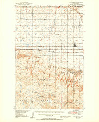
(8)- 1950 Map of Vanville NE
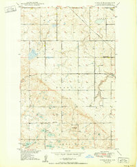 1950 Vanville NE1950 Print · USGSPost-war Burke County rural life centers on isolated schoolhouses and the rail line in the early fifties. Locate family roots near Big Spring Sch, Ward Hill, and the tracks of the Great Northern railroad.
 - 1950 Map of Bowbells
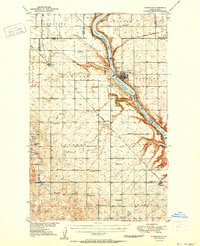
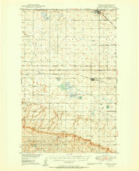
 1950 Bowbells1950 Print · USGSThe Burke County prairie meets the international border in the mid-twentieth century, centered on the vital rail junction at Bowbells. Genealogists and historians can trace rural school districts like Masek Sch and explore the early water management of the CCC Dam.2 unique versions available
 - 1950 Map of Kenmare
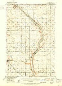
 1950 Kenmare1950 Print · USGSKenmare and the surrounding prairies are captured here at mid-century, dominated by the long ribbon of the Des Lacs lakes. Local researchers can trace rural life through numerous country schoolhouses and churches, including Buck Sch, Our Savior Ch, and the Kenmare Landing Field.2 unique versions available
 - 1950 Map of Flaxton
 1950 Flaxton1950 Print · USGSThe North Dakota borderlands near Northgate are captured here during a period of robust rural organization and rail activity. Researchers can trace early school districts and pioneer church sites like Danish Ch, along with the Woburn settlement and a local Landing Field.
 - 1950 Map of Columbus
 1950 Columbus1950 Print · USGSThe Burke County borderlands at the dawn of the fifties reveal a landscape defined by international boundaries and a thriving coal industry. Local historians can trace the rail-side growth of Columbus and Kincaid, or locate rural landmarks like the Strip Mine and South St Olaf Ch.2 unique versions available
 - 1950 Map of Portal
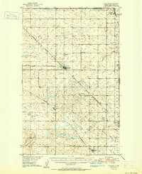
 1950 Portal1950 Print · USGSThe international border at Portal and the surrounding coalfields of Burke County are captured here at mid-century. Genealogists can trace family roots through numerous country churches and ethnic burial sites like the Swedish Cem and Norwegian Cem.2 unique versions available
 - 1953 Map of Williston, 1968 Print
 1953 Williston1968 Print · USGSThe North Dakota high plains meet the waters of Sakakawea Lake in this mid-century survey of the northern borderlands. Trace the rail-and-ranch economy through sites like Anderson Sky Ranch, Sevenmile Corner, and the strip mines near Columbus.2 unique versions available
 - 1957 Map of Williston
 1957 Williston1957 Print · USGSNorthwestern North Dakota is shown here during the mid-fifties, dominated by the sweeping plains and the Missouri River valley. Genealogists and local historians can trace the paths of the Great Northern railroad through Williston, Tioga, and Ray, or locate early industry like the coal strip mines near Lignite.
End of results
Showing maps 1-8 of 8
Top cities of Burke County
- Bowbells historical maps
- Powers Lake historical maps
- Lignite historical maps
- Columbus historical maps
- Portal historical maps
- Battleview historical maps
See more
Frequently asked questions
- What are the different types of historical maps available for Burke County?
- What is the oldest map of Burke County?
- Where can I purchase historical maps of Burke County for my home or office?
- Where can I download high-res historical maps of Burke County?
- Are there historical topographic maps available for Burke County?
- Is there historical aerial imagery available for Burke County?
- Where are historical maps of Burke County sourced from?