Old Maps of Crystal Springs, North Dakota for Academic Research
Study the evolution of Crystal Springs with 9 high-resolution historic maps. Whether you're teaching, researching, or modeling changes in land use, these maps provide essential visual documentation of urban, environmental, and geographic change.
- Analyze long-term change: Track patterns in development, transportation, and natural features.
- Ideal for environmental or urban studies: Support academic projects with primary historical map data.
- Use in the classroom or lab: Educators and researchers rely on these maps to bring historical context to life.
These maps are a powerful tool for teaching, research, and visualizing how Crystal Springs has changed over the decades.
Crystal Springs, ND maps
(9)- 1953 Map of Jamestown
 1953 Jamestown1953 Print · USGSSoutheastern North Dakota was a thriving rail and agricultural corridor in the early fifties, anchored by the James River. Researchers can trace the footprints of institutional landmarks like the North Dakota State Hospital and historic sites such as Whitestone Hill Battlefield Park.3 unique versions available
 - 1955 Map of Crystal Springs, 1956 Print
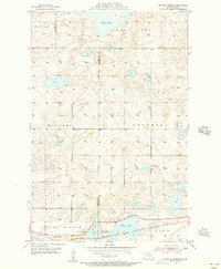 1955 Crystal Springs1956 Print · USGSThe Missouri Coteau prairie of the mid-1950s is meticulously detailed here, showing the intricate wetland systems surrounding Chase Lake. Researchers can locate historic rural schoolhouses like School No 3 and trace the Northern Pacific rail line through Crystal Springs.2 unique versions available
 - 1956 Map of Jamestown
 1956 Jamestown1956 Print · USGSThe James River valley and the vast alkali lake country of south-central North Dakota are captured here in the mid-fifties. Genealogists can trace family farms across several counties, locating small rail stops like Medberry and monuments like Whitestone Hill Battlefield Park.
 - 1985 Map of Steele, 1994 Print
 1985 Steele1994 Print · USGSCentral North Dakota’s prairie pothole region is showcased here in the mid-1980s, revealing a landscape of vital wetlands and rail-dependent towns. Researchers can trace family ties and land use near Steele, Napoleon, and the many waterfowl production areas like Slade National Wildlife Refuge.
 - 2011 Map of Crystal Springs, 2011 Print
 2011 Crystal Springs2011 Print · USGSCovers Crystal Springs, including Stutsman County, Kidder County, and other nearby areas
 - 2014 Map of Crystal Springs, 2014 Print
 2014 Crystal Springs2014 Print · USGSCovers Crystal Springs, including Stutsman County, Kidder County, and other nearby areas
 - 2018 Map of Crystal Springs, 2018 Print
 2018 Crystal Springs2018 Print · USGSCovers Crystal Springs, including Stutsman County, Kidder County, and other nearby areas
 - 2020 Map of Crystal Springs, 2020 Print
 2020 Crystal Springs2020 Print · USGSCovers Crystal Springs, including Stutsman County, Kidder County, and other nearby areas
 - 2024 Map of Crystal Springs, 2024 Print
 2024 Crystal Springs2024 Print · USGSThe prairie pothole country of the North Dakota plains is captured here at the Kidder and Stutsman county line. Researchers can trace the protected wetlands of the Chase Lake National Wildlife Refuge and the settlement at Crystal Springs.
End of results
Showing maps 1-9 of 9
Top cities near Crystal Springs
Frequently asked questions
- What are the different types of historical maps available for Crystal Springs?
- What is the oldest map of Crystal Springs?
- Where can I purchase historical maps of Crystal Springs for my home or office?
- Where can I download high-res historical maps of Crystal Springs?
- Are there historical topographic maps available for Crystal Springs?
- Is there historical aerial imagery available for Crystal Springs?
- Where are historical maps of Crystal Springs sourced from?