
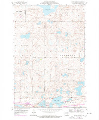
1955 Map of Crystal Springs
USGS Topo · Published 1956About this map
Chase Lake dominates the northern portion of this mid-century prairie landscape, where the irregular topography of the Missouri Coteau creates a complex network of wetlands and seasonal potholes. The community of Crystal Springs serves as the primary settlement, situated along the southern edge of the quadrangle where the Northern Pacific railroad tracks parallel the main highway. This corridor represents the vital transportation artery of the era, connecting the local agricultural township with larger markets.
Find a feature on this map
14 named features on this map. Tap any name to fly to it.
Don’t see what you’re looking for? This feature index may not catch every label — zoom into the map to look around manually.
Map Details
Editions of this 1955 Crystal Springs Map
2 editions found
Other maps of this area

1952 · Tappen SE
USGS Topo · 1:24,000

1952 · Tappen NE
USGS Topo · 1:24,000

1952 · New Rockford
USGS Topo · 1:250,000

1953 · Jamestown
USGS Topo · 1:250,000

1954 · Medina
USGS Topo · 1:24,000

1955 · Medina SW
USGS Topo · 1:24,000

1955 · Medina SE
USGS Topo · 1:24,000

1956 · New Rockford
USGS Topo · 1:250,000

1956 · Jamestown
USGS Topo · 1:250,000

1971 · New Rockford
USGS Topo · 1:250,000