Old Maps of Kidder County, North Dakota for Hiking & Exploration
Hike through history with 231 historic maps of Kidder County. Explore old trails, ghost towns, and forgotten backroads — perfect for outdoor adventurers and local explorers.
- Rediscover forgotten places: Map out old mining camps, roads, and footpaths that no longer exist on modern maps.
- Layer with modern tools: Combine with LiDAR or satellite views to plan hikes through historical terrain.
- Made for exploration: Popular among hikers, overlanders, and local history lovers.
Use these maps to find adventure and explore the hidden past of Kidder County.
Kidder County, ND maps
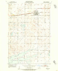
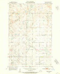
(231)- 1951 Map of Driscoll, 1953 Print
 1951 Driscoll1953 Print · USGSThe Burleigh County prairie comes alive in the early fifties, centered on the railroad town of Driscoll. Genealogists and local historians can trace the locations of Zion Ch, the Chaska Historic Site, and numerous rural schools like School No 4.
 - 1952 Map of Tappen South, 1954 Print
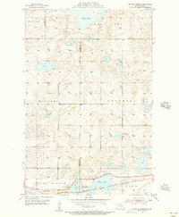
 1952 Tappen South1954 Print · USGSIn the early fifties, this Kidder County landscape was defined by the Northern Pacific rail corridor and a vast network of wetlands. Researchers can trace the layout of early rural life through landmarks like Camp Grassick, Sibley Cem, and the old School No 28.
 - 1952 Map of Tappen SE, 1954 Print
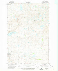
 1952 Tappen SE1954 Print · USGSMid-century Kidder County comes into focus in this detailed study of the prairie wetlands and rail-fed townships east of the state capital. Genealogists and historians can trace local school districts such as School No 1, the Northern Pacific rail line, and the shores of Lake George.
 - 1952 Map of Tappen NE, 1954 Print
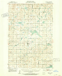
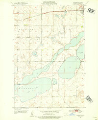
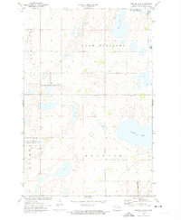
 1952 Tappen NE1954 Print · USGSKidder County's prairie pothole region comes into focus during the early fifties as the railroad and rural school districts defined local life. Trace the path of the Northern Pacific through Tappen or locate School No 1 near Sweetwater Lake.2 unique versions available
 - 1952 Map of Dawson, 1954 Print
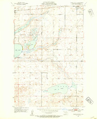
 1952 Dawson1954 Print · USGSKidder County in the early 1950s was a landscape of expansive prairie lakes and railroad-dependent towns. Genealogists and local historians can trace the rural schoolhouse at Liberty Sch and the rail-side growth of Dawson near Alkaline Lake.2 unique versions available
 - 1952 Map of Tappen North, 1954 Print
 1952 Tappen North1954 Print · USGSKidder County's prairie pothole region is detailed here in the early fifties, showing a rural landscape organized by township lines and small rail-side settlements. Researchers can locate family landmarks like the Norwegian Ch, Fisher Cem, and McPhail Butte Historic Monument.
 - 1952 Map of Steele NE, 1954 Print
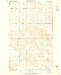
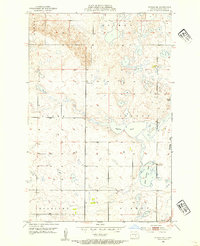 1952 Steele NE1954 Print · USGSKidder County's prairie wetland system is captured here in the early fifties as the community of Dawson began its post-war decade. Genealogists and local historians can locate early landmarks like Allen Cem and rural educational sites like School No 1.2 unique versions available
 - 1952 Map of Steele, 1954 Print
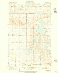
 1952 Steele1954 Print · USGSSteele and the surrounding Kidder County prairie are captured here in the early fifties as the region balanced agriculture with conservation. Researchers can locate the Northern Pacific rail line, rural schoolhouses like School No 2, and the sprawling Long Lake National Wildlife Refuge.2 unique versions available
 - 1952 Map of Steele NW, 1954 Print
 1952 Steele NW1954 Print · USGSKidder County's rural township structure is preserved here in the early fifties, showing a landscape defined by glacial prairie potholes. Genealogists and historians can locate community focal points like Allen Sch and Woodlawn Cem.
 - 1952 Map of New Rockford, 1968 Print
 1952 New Rockford1968 Print · USGSThe North Dakota prairie during the mid-1950s was a landscape of rail-dependent farm towns and vast wildlife refuges. Genealogists and historians can trace the foundations of local communities at Fort Totten Indian Agenc, Concordia Lutheran Church, and the Bowdon Country Church and Cemetery.3 unique versions available
 - 1953 Map of Jamestown
 1953 Jamestown1953 Print · USGSSoutheastern North Dakota was a thriving rail and agricultural corridor in the early fifties, anchored by the James River. Researchers can trace the footprints of institutional landmarks like the North Dakota State Hospital and historic sites such as Whitestone Hill Battlefield Park.3 unique versions available
 - 1954 Map of Bismarck, 1967 Print
 1954 Bismarck1967 Print · USGSBismarck and the Missouri River basin are shown in the mid-1960s as the Oahe Reservoir reshaped the valley. Genealogists can trace family-named landmarks like Dog Tooth Buttes and small prairie settlements such as Fort Yates, Selfridge, and Brisbane.2 unique versions available
 - 1954 Map of McClusky, 1968 Print
 1954 McClusky1968 Print · USGSCentral North Dakota was undergoing a profound transformation in the fifties as the newly formed Lake Sakakawea reshaped the Missouri River valley. Genealogists and historians can trace rail-town development along the Soo Line and locate historic markers like Garrison Dam or the Lewis and Clark Trail.3 unique versions available
 - 1955 Map of Crystal Springs, 1956 Print
 1955 Crystal Springs1956 Print · USGSThe Missouri Coteau prairie of the mid-1950s is meticulously detailed here, showing the intricate wetland systems surrounding Chase Lake. Researchers can locate historic rural schoolhouses like School No 3 and trace the Northern Pacific rail line through Crystal Springs.2 unique versions available
 - 1955 Map of Medina SW, 1957 Print
 1955 Medina SW1957 Print · USGSKidder and Stutsman counties appear here in the mid-fifties, showing a landscape of prairie potholes and the vital Northern Pacific rail line. Researchers can locate several rural landmarks, including School No 3 and the Crystal Springs Cem.
 - 1956 Map of New Rockford
 1956 New Rockford1956 Print · USGSMid-century central North Dakota is captured here as a landscape of prairie rail towns and vast wildlife refuges. Trace family roots at the Bowdon Country Church and Cemetery or locate the old St Michael Mission School and Fort Totten.
 - 1956 Map of Jamestown
 1956 Jamestown1956 Print · USGSThe James River valley and the vast alkali lake country of south-central North Dakota are captured here in the mid-fifties. Genealogists can trace family farms across several counties, locating small rail stops like Medberry and monuments like Whitestone Hill Battlefield Park.
 - 1958 Map of Bismarck
 1958 Bismarck1958 Print · USGSCentral North Dakota in the late fifties is defined by the Missouri River and the sprawling Standing Rock Indian Reservation. Genealogists and historians can trace rail-line outposts like Sedalia Siding or explore local landmarks like Saint Anthony and Fort Lincoln State Park/Museum.
 - 1958 Map of McClusky
 1958 McClusky1958 Print · USGSCentral North Dakota was undergoing a profound change in the late fifties as the Garrison Reservoir filled behind its massive new dam. Trace the early layout of Riverdale, the Lewis and Clark Trail, and the vanishing rail stops of the Northern Pacific.
 - 1971 Map of New Rockford, 1974 Print
 1971 New Rockford1974 Print · USGSCentral North Dakota was a landscape of wildlife refuges and rail-linked agricultural towns in the early seventies. Genealogists and local historians can trace the development of the Fort Totten Indian Reservation and locate old railway points like Maddock, Hamal, and Kloten.
 - 1972 Map of Tuttle, 1974 Print
 1972 Tuttle1974 Print · USGSThe rail-and-prairie landscape of Kidder County is captured here in the early 1970s, centered on the village of Tuttle. Local historians can trace the Burlington Northern railroad corridor and locate the St Petri Cem and Holy Cross Cem Townhall.
 - 1972 Map of Kunkel Lake, 1974 Print
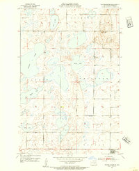
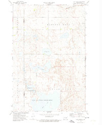
 1972 Kunkel Lake1974 Print · USGSKidder County's wetland-rich prairie is preserved here during the early seventies, showcasing a complex network of glacial lakes and waterfowl habitats. Researchers can locate remote rural landmarks like a Cem, the Landing Field, and the Burlington Northern rail line.2 unique versions available
 - 1972 Map of Lake Louise, 1974 Print
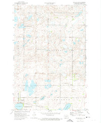
 1972 Lake Louise1974 Print · USGSStutsman County is depicted during the early 1970s as a vital corridor for prairie conservation and rail transport. Researchers can trace the extensive boundaries of the Chase Lake National Wildlife Refuge and locate rural landmarks like the Townhall and the Burlington Northern line.2 unique versions available
 - 1972 Map of Horsehead Lake, 1974 Print
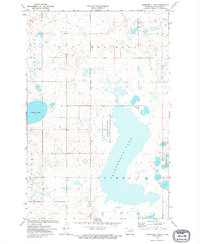 1972 Horsehead Lake1974 Print · USGSKidder County's prairie wetland environment is preserved here in the early seventies, dominated by the expansive Horsehead Lake. Genealogists and historians can trace local landmarks like the Townhall and conservation sites like the National Waterfowl Production Area.
 - 1972 Map of Lake Williams, 1974 Print
 1972 Lake Williams1974 Print · USGSKidder County in the early 1970s reveals a landscape defined by the Burlington Northern railroad and expansive prairie wetlands. Genealogists and local historians can trace sites like the Petersville Cem, the village of Pettibone, and the local Townhall.
Showing maps 1-25 of 231
Top cities of Kidder County
- Steele historical maps
- Tappen historical maps
- Tuttle historical maps
- Pettibone historical maps
- Dawson historical maps
- Robinson historical maps
See more
Frequently asked questions
- What are the different types of historical maps available for Kidder County?
- What is the oldest map of Kidder County?
- Where can I purchase historical maps of Kidder County for my home or office?
- Where can I download high-res historical maps of Kidder County?
- Are there historical topographic maps available for Kidder County?
- Is there historical aerial imagery available for Kidder County?
- Where are historical maps of Kidder County sourced from?