1990s Maps of McHenry County, North Dakota
Explore 2 historic maps of McHenry County from the 1990s. These maps offer a rare glimpse into what life looked like during the 1990s — showing old roads, neighborhoods, homes, and landmarks that have changed or disappeared over time.
Whether you're researching your family's past, planning a metal detecting trip, or studying how McHenry County's landscape evolved across the 1990s, these high-resolution maps are a powerful tool for exploring the history of this region.
- Focus on a specific era: All maps on this page are from the 1990s, giving you a focused view of this time period.
- See what’s changed: Compare century-old streets, trails, and buildings to today's modern landscape using overlays and satellite layers.
- Research with precision: Use these maps for genealogy, historical research, land use analysis, or educational projects.
- View, download, or print: Maps are fully viewable online in high resolution, and can be downloaded or printed for your own records.
Start exploring McHenry County's history through authentic maps from the 1990s. This is your window into the past.
McHenry County, ND maps
(2)- 1997 Map of Riga, 2001 Print
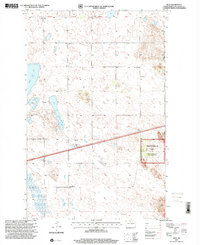 1997 Riga2001 Print · USGSMcHenry County prairie life and managed forestry are captured here in the late nineties, showing the organized settlement of the northern plains. Researchers can locate several historic rural schools such as White Rock Sch and Rose Hill Sch, alongside the Thompson Cem and Riga.
 - 1997 Map of Towner NW, 2001 Print
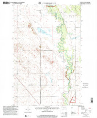 1997 Towner NW2001 Print · USGSThe Souris River valley in McHenry County is captured here in the late nineties, showing a landscape of sweeping prairie and protected wetlands. Genealogists can locate family-named landmarks and rural schoolhouses like Poplar Grove Sch No 1 and Red Cross Sch No 1.
End of results
Showing maps 1-2 of 2
Top cities of McHenry County
- Velva historical maps
- Towner historical maps
- Drake historical maps
- Anamoose historical maps
- Granville historical maps
- Upham historical maps
See more
Frequently asked questions
- What are the different types of historical maps available for McHenry County?
- What is the oldest map of McHenry County?
- Where can I purchase historical maps of McHenry County for my home or office?
- Where can I download high-res historical maps of McHenry County?
- Are there historical topographic maps available for McHenry County?
- Is there historical aerial imagery available for McHenry County?
- Where are historical maps of McHenry County sourced from?