1990s Maps of Four Bears Segment, North Dakota
Explore 2 historic maps of Four Bears Segment from the 1990s. These maps offer a rare glimpse into what life looked like during the 1990s — showing old roads, neighborhoods, homes, and landmarks that have changed or disappeared over time.
Whether you're researching your family's past, planning a metal detecting trip, or studying how Four Bears Segment's landscape evolved across the 1990s, these high-resolution maps are a powerful tool for exploring the history of this region.
- Focus on a specific era: All maps on this page are from the 1990s, giving you a focused view of this time period.
- See what’s changed: Compare century-old streets, trails, and buildings to today's modern landscape using overlays and satellite layers.
- Research with precision: Use these maps for genealogy, historical research, land use analysis, or educational projects.
- View, download, or print: Maps are fully viewable online in high resolution, and can be downloaded or printed for your own records.
Start exploring Four Bears Segment's history through authentic maps from the 1990s. This is your window into the past.
Four Bears Segment, ND maps
(2)- 1997 Map of Blue Buttes, 2001 Print
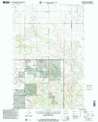 1997 Blue Buttes2001 Print · USGSMcKenzie County's badlands were a working landscape of ranching and energy extraction in the late 1990s. Researchers can trace land use through local landmarks like the Van Dyke Ranch, the Redeemer Cem, and the specialized Keogh Airstrip.
 - 1997 Map of Blue Buttes SE, 2001 Print
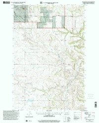 1997 Blue Buttes SE2001 Print · USGSMcKenzie County was a landscape of high buttes and isolated ranching outposts during the late twentieth century. Genealogists and researchers can locate specific homesteads like D Sivertson and the C Mercer Ranch near the Fort Berthold Indian Reservation boundary.
End of results
Showing maps 1-2 of 2
Top cities near Four Bears Segment
Top neighborhoods of Four Bears Segment
Frequently asked questions
- What are the different types of historical maps available for Four Bears Segment?
- What is the oldest map of Four Bears Segment?
- Where can I purchase historical maps of Four Bears Segment for my home or office?
- Where can I download high-res historical maps of Four Bears Segment?
- Are there historical topographic maps available for Four Bears Segment?
- Is there historical aerial imagery available for Four Bears Segment?
- Where are historical maps of Four Bears Segment sourced from?