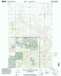
1997 Map of Blue Buttes
USGS Topo · Published 2001About this map
Hawkeye Valley and the surrounding badlands of McKenzie County define this landscape as it appeared in the late twentieth century. The map highlights a remote ranching and industrial frontier where the Little Missouri National Grassland meets the western edge of the Fort Berthold Indian Reservation. Settlement is sparse, represented by family operations like the Van Dyke Ranch and Keogh Ranch, while the local social fabric is marked by the Redeemer Cem and Reservation Sch. The terrain is punctuated by distinctive landforms, including Blue Buttes, Table Butte, and Chimney Butte. These geological features overlook a landscape increasingly shaped by energy extraction, evidenced by a large Oil Field, the Texaco Office, and multiple industrial pipelines. The inclusion of the Keogh Airstrip underscores the vast distances and specialized infrastructure required to manage these isolated prairie resources.
Find a feature on this map
22 named features on this map. Tap any name to fly to it.
Don’t see what you’re looking for? This feature index may not catch every label — zoom into the map to look around manually.
Map Details
Editions of this 1997 Blue Buttes Map
This is the sole edition of this map. No revisions or reprints were ever made.
Other maps of this area

1953 · Williston
USGS Topo · 1:250,000

1953 · Watford City
USGS Topo · 1:250,000

1957 · Williston
USGS Topo · 1:250,000

1957 · Watford City
USGS Topo · 1:250,000

1965 · Keene
USGS Topo · 1:24,000

1965 · Johnsons Corner
USGS Topo · 1:24,000

1965 · Charlson
USGS Topo · 1:24,000

1965 · Blue Buttes
USGS Topo · 1:24,000

1965 · Charlson SW
USGS Topo · 1:24,000

1965 · Blue Buttes SE
USGS Topo · 1:24,000