1900s (20th Century) Maps of Riverdale, North Dakota
Explore 9 historic maps of Riverdale from the 1900s (20th Century). These maps offer a rare glimpse into what life looked like during the 1900s — showing old roads, neighborhoods, homes, and landmarks that have changed or disappeared over time.
Whether you're researching your family's past, planning a metal detecting trip, or studying how Riverdale's landscape evolved across the 1900s, these high-resolution maps are a powerful tool for exploring the history of this region.
- Focus on a specific era: All maps on this page are from the 1900s, giving you a focused view of this time period.
- See what’s changed: Compare century-old streets, trails, and buildings to today's modern landscape using overlays and satellite layers.
- Research with precision: Use these maps for genealogy, historical research, land use analysis, or educational projects.
- View, download, or print: Maps are fully viewable online in high resolution, and can be downloaded or printed for your own records.
Start exploring Riverdale's history through authentic maps from the 1900s. This is your window into the past.
Riverdale, ND maps
(9)- 1922 Map of Garrison
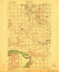 1922 Garrison1922 Print · USGSIn the early 1920s, McLean County was a landscape of steam-powered transit and scattered prairie schoolhouses. Researchers can trace the original Soo Line rail corridor and locate rural landmarks like Ireland School, Baker School, and the winding Snake Creek valley.2 unique versions available
 - 1948 Map of Stanton, 1962 Print
 1948 Stanton1962 Print · USGSMid-century Mercer and McLean Counties are shown during the transformation of the Missouri River valley. Genealogists can locate family-named landmarks like Williams Sch, the Stanton Cem, and the historic Ft Clark (Site) near the Knife River confluence.
 - 1949 Map of Stanton
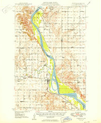 1949 Stanton1949 Print · USGSThe Missouri River valley stands at the brink of transformation in the late 1940s as the massive Garrison Dam project begins near Riverdale. Researchers can trace the original river course and numerous family-named schools like Baisch Sch and Matton Sch alongside the Northern Pacific rail line.
 - 1954 Map of McClusky, 1968 Print
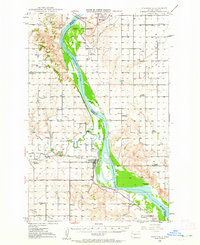
 1954 McClusky1968 Print · USGSCentral North Dakota was undergoing a profound transformation in the fifties as the newly formed Lake Sakakawea reshaped the Missouri River valley. Genealogists and historians can trace rail-town development along the Soo Line and locate historic markers like Garrison Dam or the Lewis and Clark Trail.3 unique versions available
 - 1958 Map of McClusky
 1958 McClusky1958 Print · USGSCentral North Dakota was undergoing a profound change in the late fifties as the Garrison Reservoir filled behind its massive new dam. Trace the early layout of Riverdale, the Lewis and Clark Trail, and the vanishing rail stops of the Northern Pacific.
 - 1969 Map of Garrison Dam South, 1971 Print
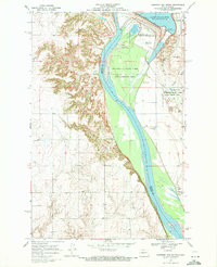 1969 Garrison Dam South1971 Print · USGSThe Missouri River valley was undergoing significant transformation in the late sixties as the massive Garrison Dam reshaped the North Dakota landscape. Researchers can trace the layout of Riverdale, the Garrison Dam National Fish Hatchery, and the rural St Pauls Ch.2 unique versions available
 - 1972 Map of Garrison Dam North, 1974 Print
 1972 Garrison Dam North1974 Print · USGSIn the early seventies, this part of McLean County centered on the massive transformation of the Missouri valley into a regional recreation hub. Researchers can trace the Old Fort Stevenson Military Reservation Boundary and locate early sites like Pick City and Camp Dominic Savio.
 - 1972 Map of Riverdale South, 1974 Print
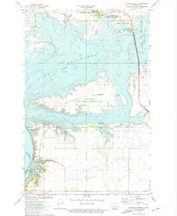
 1972 Riverdale South1974 Print · USGSMcLean County is captured in the early 1970s, showing the Missouri River valley and the planned community of Riverdale. Researchers can trace the path of the Old Railroad Grade and locate local landmarks like Clark Landing Field and Chester.
 - 1972 Map of Riverdale North, 1974 Print
 1972 Riverdale North1974 Print · USGSMcLean County is transformed by the Missouri River reservoirs in the early seventies, showcasing a massive landscape of dams and wildlife refuges. Researchers can trace the Old Ft Stevenson Mil Res Bdy and explore the mid-century layout of Riverdale.2 unique versions available
End of results
Showing maps 1-9 of 9
Top cities near Riverdale
- Garrison historical maps
- Underwood historical maps
- Stanton historical maps
- Pick City historical maps
- Coleharbor historical maps
Frequently asked questions
- What are the different types of historical maps available for Riverdale?
- What is the oldest map of Riverdale?
- Where can I purchase historical maps of Riverdale for my home or office?
- Where can I download high-res historical maps of Riverdale?
- Are there historical topographic maps available for Riverdale?
- Is there historical aerial imagery available for Riverdale?
- Where are historical maps of Riverdale sourced from?