1970s Maps of White Shield, North Dakota
Explore 2 historic maps of White Shield from the 1970s. These maps offer a rare glimpse into what life looked like during the 1970s — showing old roads, neighborhoods, homes, and landmarks that have changed or disappeared over time.
Whether you're researching your family's past, planning a metal detecting trip, or studying how White Shield's landscape evolved across the 1970s, these high-resolution maps are a powerful tool for exploring the history of this region.
- Focus on a specific era: All maps on this page are from the 1970s, giving you a focused view of this time period.
- See what’s changed: Compare century-old streets, trails, and buildings to today's modern landscape using overlays and satellite layers.
- Research with precision: Use these maps for genealogy, historical research, land use analysis, or educational projects.
- View, download, or print: Maps are fully viewable online in high resolution, and can be downloaded or printed for your own records.
Start exploring White Shield's history through authentic maps from the 1970s. This is your window into the past.
White Shield, ND maps
(2)- 1970 Map of Hay Flat, 1973 Print
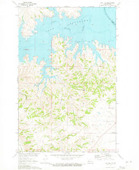 1970 Hay Flat1973 Print · USGSDunn County's high plains meet the intricate new shoreline of the Missouri River Basin during the early seventies. Genealogists and local historians can locate Lincoln Memorial Cem and trace the rugged coulees surrounding Old Man Dancing Butte.
 - 1970 Map of Saddle Butte, 1973 Print
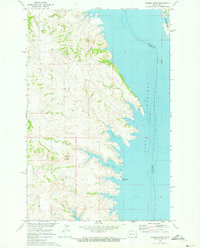 1970 Saddle Butte1973 Print · USGSThe Missouri River breaks in western North Dakota are shown just as the reservoir reached its mature levels in the early seventies. Genealogists and researchers can trace the submerged county lines and find landmarks like Saddle Butte and Saddle Butte Bay.
End of results
Showing maps 1-2 of 2
Top cities near White Shield
Top neighborhoods of White Shield
Frequently asked questions
- What are the different types of historical maps available for White Shield?
- What is the oldest map of White Shield?
- Where can I purchase historical maps of White Shield for my home or office?
- Where can I download high-res historical maps of White Shield?
- Are there historical topographic maps available for White Shield?
- Is there historical aerial imagery available for White Shield?
- Where are historical maps of White Shield sourced from?