1960s Maps of Ramsey County, North Dakota
Explore 3 historic maps of Ramsey County from the 1960s. These maps offer a rare glimpse into what life looked like during the 1960s — showing old roads, neighborhoods, homes, and landmarks that have changed or disappeared over time.
Whether you're researching your family's past, planning a metal detecting trip, or studying how Ramsey County's landscape evolved across the 1960s, these high-resolution maps are a powerful tool for exploring the history of this region.
- Focus on a specific era: All maps on this page are from the 1960s, giving you a focused view of this time period.
- See what’s changed: Compare century-old streets, trails, and buildings to today's modern landscape using overlays and satellite layers.
- Research with precision: Use these maps for genealogy, historical research, land use analysis, or educational projects.
- View, download, or print: Maps are fully viewable online in high resolution, and can be downloaded or printed for your own records.
Start exploring Ramsey County's history through authentic maps from the 1960s. This is your window into the past.
Ramsey County, ND maps
(3)- 1962 Map of Starkweather, 1964 Print
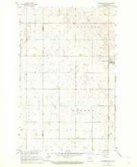 1962 Starkweather1964 Print · USGSThe rural prairie landscape around Starkweather is captured here in the early sixties, showing a region defined by the Great Northern rail line. Researchers can trace the Towner and Ramsey County line or locate local landmarks like Bergen Ch and Davis Slough.
 - 1962 Map of Starkweather NE, 1964 Print
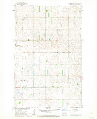 1962 Starkweather NE1964 Print · USGSRamsey County in the early 1960s reveals a structured agricultural grid defined by the township divisions of Klingstrup and Royal. Genealogists and local historians can trace the town of Starkweather, nearby Calvary Cem, and the waters of Shea Slough.
 - 1962 Map of Hamar, 1965 Print
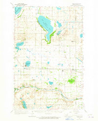 1962 Hamar1965 Print · USGSBenson and Ramsey counties are depicted in the early sixties as a network of lakeside settlements and prairie rail lines. You can locate rural schoolhouses and family landmarks like Sigdal Ch, the Indian Mound, and cemeteries in Warwick and Hamar.
End of results
Showing maps 1-3 of 3
Top cities of Ramsey County
- Devils Lake historical maps
- Edmore historical maps
- Grand Harbor historical maps
- Starkweather historical maps
- Crary historical maps
- Webster historical maps
See more
Frequently asked questions
- What are the different types of historical maps available for Ramsey County?
- What is the oldest map of Ramsey County?
- Where can I purchase historical maps of Ramsey County for my home or office?
- Where can I download high-res historical maps of Ramsey County?
- Are there historical topographic maps available for Ramsey County?
- Is there historical aerial imagery available for Ramsey County?
- Where are historical maps of Ramsey County sourced from?