1960s Maps of Tuller Township, North Dakota
Explore 4 historic maps of Tuller Township from the 1960s. These maps offer a rare glimpse into what life looked like during the 1960s — showing old roads, neighborhoods, homes, and landmarks that have changed or disappeared over time.
Whether you're researching your family's past, planning a metal detecting trip, or studying how Tuller Township's landscape evolved across the 1960s, these high-resolution maps are a powerful tool for exploring the history of this region.
- Focus on a specific era: All maps on this page are from the 1960s, giving you a focused view of this time period.
- See what’s changed: Compare century-old streets, trails, and buildings to today's modern landscape using overlays and satellite layers.
- Research with precision: Use these maps for genealogy, historical research, land use analysis, or educational projects.
- View, download, or print: Maps are fully viewable online in high resolution, and can be downloaded or printed for your own records.
Start exploring Tuller Township's history through authentic maps from the 1960s. This is your window into the past.
Tuller Township, ND maps
(4)- 1962 Map of Lisbon, 1964 Print
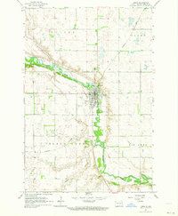 1962 Lisbon1964 Print · USGSLisbon and the winding Sheyenne River valley are captured here in the early sixties, showing the town at a peak of mid-century development. Genealogists and local historians can locate the State Soldiers Home, Oakwood Cemetery, and the Northern Pacific rail line.
 - 1962 Map of Elliott, 1964 Print
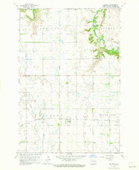 1962 Elliott1964 Print · USGSIn the early 1960s, this Ransom County prairie landscape was defined by the Northern Pacific railroad and the winding Sheyenne River. Genealogists and local historians can trace rural landmarks like Dick Cem, School No 1, and the rail siding at Elliott.
 - 1967 Map of Nome SE, 1969 Print
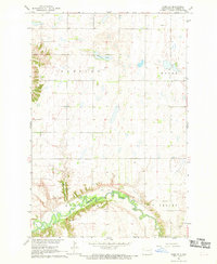 1967 Nome SE1969 Print · USGSRansom County farmland meets the winding valley of the Sheyenne River during the late sixties. Genealogists and local historians can locate the Bethania Cem, Fillmore Ch, and the riverside Griswold Mine.
 - 1967 Map of Buttzville, 1969 Print
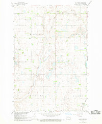 1967 Buttzville1969 Print · USGSRansom County farming townships and the prairie rail corridor are captured here in the late sixties. Genealogists and local historians can locate the West St Olaf Ch, the Northern Pacific rail line, and the small settlement of Buttzville.
End of results
Showing maps 1-4 of 4
Top cities near Tuller Township
- Lisbon historical maps
- Enderlin historical maps
- Sheldon historical maps
- Fort Ransom historical maps
- Nome historical maps
- Elliott historical maps
Frequently asked questions
- What are the different types of historical maps available for Tuller Township?
- What is the oldest map of Tuller Township?
- Where can I purchase historical maps of Tuller Township for my home or office?
- Where can I download high-res historical maps of Tuller Township?
- Are there historical topographic maps available for Tuller Township?
- Is there historical aerial imagery available for Tuller Township?
- Where are historical maps of Tuller Township sourced from?