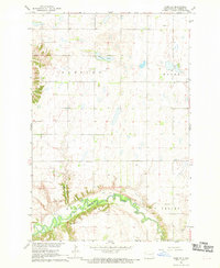
1967 Map of Nome SE
USGS Topo · Published 1969About this map
The Sheyenne River carves a deep, winding valley through the southern portion of this landscape, creating a sharp contrast between the level upland plateaus and the dissected river bluffs. In this agricultural region of Ransom County, the map records rural landmarks such as the Bethania Cem and Fillmore Ch, which served the surrounding townships of Preston, Moore, and Springer. Resource extraction and land use are evident through features like the Griswold Mine and various Gravel Pits concentrated near the river’s edge. Elevated points like Oestreicher Hill and Scott Hill provide natural overlooks above the valley floor, while Brown Lake and a prominent Spring indicate the local hydrology in a terrain otherwise defined by section lines and field boundaries.
Find a feature on this map
18 named features on this map. Tap any name to fly to it.
Don’t see what you’re looking for? This feature index may not catch every label — zoom into the map to look around manually.
Map Details
Editions of this 1967 Nome SE Map
This is the sole edition of this map. No revisions or reprints were ever made.
Other maps of this area

1897 · Tower
USGS Topo · 1:125,000

1953 · Fargo
USGS Topo · 1:250,000

1956 · Fargo
USGS Topo · 1:250,000
1962 · Englevale
USGS Topo · 1:24,000

1962 · Lisbon
USGS Topo · 1:24,000

1962 · Elliott
USGS Topo · 1:24,000

1965 · Lucca
USGS Topo · 1:24,000

1967 · Ft. Ransom
USGS Topo · 1:24,000
1967 · Nome
USGS Topo · 1:24,000
1967 · Kathryn
USGS Topo · 1:24,000