1980s Maps of Renville County, North Dakota
Explore 3 historic maps of Renville County from the 1980s. These maps offer a rare glimpse into what life looked like during the 1980s — showing old roads, neighborhoods, homes, and landmarks that have changed or disappeared over time.
Whether you're researching your family's past, planning a metal detecting trip, or studying how Renville County's landscape evolved across the 1980s, these high-resolution maps are a powerful tool for exploring the history of this region.
- Focus on a specific era: All maps on this page are from the 1980s, giving you a focused view of this time period.
- See what’s changed: Compare century-old streets, trails, and buildings to today's modern landscape using overlays and satellite layers.
- Research with precision: Use these maps for genealogy, historical research, land use analysis, or educational projects.
- View, download, or print: Maps are fully viewable online in high resolution, and can be downloaded or printed for your own records.
Start exploring Renville County's history through authentic maps from the 1980s. This is your window into the past.
Renville County, ND maps
(3)- 1980 Map of Tolley
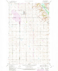 1980 Tolley1980 Print · USGSThe North Dakota prairie around Tolley is captured here during a period of rural transition in the mid-20th century. Genealogists and local historians can trace the legacy of early education and rail transport through School No 3, Trinity Cem, and the Soo Line tracks.
 - 1980 Map of Minot
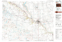 1980 Minot1980 Print · USGSNorth Dakota's northern plains are shown at the start of the 1980s, centered on the strategic rail and river hub of Minot. Genealogists and local historians can trace the transition from rural grain stops like Berthold to the significant military presence at Minot Air Force Base.
 - 1982 Map of Kenmare
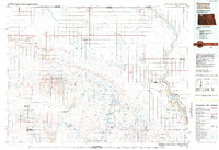 1982 Kenmare1982 Print · USGSThe high plains of northwestern North Dakota meet the Canadian border in the early 1980s, an era defined by energy production and prairie conservation. Genealogists and historians can trace the rail corridors of the Soo Line through towns like Bowbells, Flaxton, and the border crossing at Portal.
End of results
Showing maps 1-3 of 3
Top cities of Renville County
- Mohall historical maps
- Glenburn historical maps
- Sherwood historical maps
- Tolley historical maps
- Loraine historical maps
- Grano historical maps
Frequently asked questions
- What are the different types of historical maps available for Renville County?
- What is the oldest map of Renville County?
- Where can I purchase historical maps of Renville County for my home or office?
- Where can I download high-res historical maps of Renville County?
- Are there historical topographic maps available for Renville County?
- Is there historical aerial imagery available for Renville County?
- Where are historical maps of Renville County sourced from?