1960s Maps of Duerr Township, North Dakota
Explore 4 historic maps of Duerr Township from the 1960s. These maps offer a rare glimpse into what life looked like during the 1960s — showing old roads, neighborhoods, homes, and landmarks that have changed or disappeared over time.
Whether you're researching your family's past, planning a metal detecting trip, or studying how Duerr Township's landscape evolved across the 1960s, these high-resolution maps are a powerful tool for exploring the history of this region.
- Focus on a specific era: All maps on this page are from the 1960s, giving you a focused view of this time period.
- See what’s changed: Compare century-old streets, trails, and buildings to today's modern landscape using overlays and satellite layers.
- Research with precision: Use these maps for genealogy, historical research, land use analysis, or educational projects.
- View, download, or print: Maps are fully viewable online in high resolution, and can be downloaded or printed for your own records.
Start exploring Duerr Township's history through authentic maps from the 1960s. This is your window into the past.
Duerr Township, ND maps
(4)- 1964 Map of Lidgerwood, 1965 Print
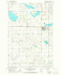 1964 Lidgerwood1965 Print · USGSLidgerwood and the surrounding Richland County prairie are documented here in the mid-1960s at a time of transitioning rail commerce. You can trace the Great Northern Line and an Old Railroad Grade, or locate family sites near the Bohemian Cem and St Johns Cem.
 - 1964 Map of Swan Lake, 1965 Print
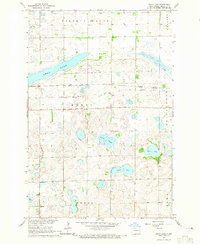 1964 Swan Lake1965 Print · USGSRichland County's prairie wetland character is captured in the mid-sixties, showing a landscape defined by glacial sloughs and transitioning rail lines. Researchers can trace the path of the Soo Line Great Northern Railroad Grade and locate Stiles or the Emmanuel Ch.
 - 1964 Map of Claire City NE, 1966 Print
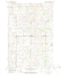 1964 Claire City NE1966 Print · USGSRichland and Roberts counties meet along the Dakotas' border in the mid-1960s, a landscape defined by prairie wetlands and small rural parishes. Genealogists can locate family landmarks like St Pauls Cem, Ferkingstad Ch, and School No 2.
 - 1964 Map of Claire City NW, 1966 Print
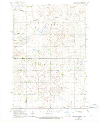 1964 Claire City NW1966 Print · USGSCrossing the North Dakota-South Dakota border in the mid-1960s, this area shows the intersection of the Sisseton Indian Reservation and various county lines. Genealogists can locate family landmarks like Bergen Ch Cem and the Nidaros Ch among the prairie sloughs.
End of results
Showing maps 1-4 of 4
Top cities near Duerr Township
- Lidgerwood historical maps
- Veblen historical maps
- New Effington historical maps
- Claire City historical maps
- Mantador historical maps
Frequently asked questions
- What are the different types of historical maps available for Duerr Township?
- What is the oldest map of Duerr Township?
- Where can I purchase historical maps of Duerr Township for my home or office?
- Where can I download high-res historical maps of Duerr Township?
- Are there historical topographic maps available for Duerr Township?
- Is there historical aerial imagery available for Duerr Township?
- Where are historical maps of Duerr Township sourced from?