1960s Maps of Slope County, North Dakota
Explore 2 historic maps of Slope County from the 1960s. These maps offer a rare glimpse into what life looked like during the 1960s — showing old roads, neighborhoods, homes, and landmarks that have changed or disappeared over time.
Whether you're researching your family's past, planning a metal detecting trip, or studying how Slope County's landscape evolved across the 1960s, these high-resolution maps are a powerful tool for exploring the history of this region.
- Focus on a specific era: All maps on this page are from the 1960s, giving you a focused view of this time period.
- See what’s changed: Compare century-old streets, trails, and buildings to today's modern landscape using overlays and satellite layers.
- Research with precision: Use these maps for genealogy, historical research, land use analysis, or educational projects.
- View, download, or print: Maps are fully viewable online in high resolution, and can be downloaded or printed for your own records.
Start exploring Slope County's history through authentic maps from the 1960s. This is your window into the past.
Slope County, ND maps
(2)- 1961 Map of Daglum, 1963 Print
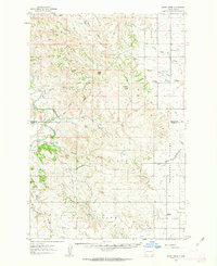
 1961 Daglum1963 Print · USGSThe western North Dakota plains near the turn of the 1960s reveal a landscape of remote schoolhouses and prairie churches. Researchers can locate vanished rural landmarks like Fisher School, the Daglum Cemetery, and Our Lady of Lourdes Ch.
 - 1961 Map of Rocky Ridge, 1963 Print
 1961 Rocky Ridge1963 Print · USGSThe North Dakota badlands of Slope and Billings Counties are captured here in the early sixties, showing a landscape of ranching and early energy extraction. Researchers can locate the Rocky Ridge Sch, White Lake Sch No 1, and the unique Burning Coal Veins near the river.
End of results
Showing maps 1-2 of 2
Top cities of Slope County
Frequently asked questions
- What are the different types of historical maps available for Slope County?
- What is the oldest map of Slope County?
- Where can I purchase historical maps of Slope County for my home or office?
- Where can I download high-res historical maps of Slope County?
- Are there historical topographic maps available for Slope County?
- Is there historical aerial imagery available for Slope County?
- Where are historical maps of Slope County sourced from?