1980s Maps of South Prairie, North Dakota
Explore 2 historic maps of South Prairie from the 1980s. These maps offer a rare glimpse into what life looked like during the 1980s — showing old roads, neighborhoods, homes, and landmarks that have changed or disappeared over time.
Whether you're researching your family's past, planning a metal detecting trip, or studying how South Prairie's landscape evolved across the 1980s, these high-resolution maps are a powerful tool for exploring the history of this region.
- Focus on a specific era: All maps on this page are from the 1980s, giving you a focused view of this time period.
- See what’s changed: Compare century-old streets, trails, and buildings to today's modern landscape using overlays and satellite layers.
- Research with precision: Use these maps for genealogy, historical research, land use analysis, or educational projects.
- View, download, or print: Maps are fully viewable online in high resolution, and can be downloaded or printed for your own records.
Start exploring South Prairie's history through authentic maps from the 1980s. This is your window into the past.
South Prairie, ND maps
(2)- 1980 Map of Minot
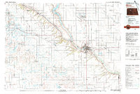 1980 Minot1980 Print · USGSNorth Dakota's northern plains are shown at the start of the 1980s, centered on the strategic rail and river hub of Minot. Genealogists and local historians can trace the transition from rural grain stops like Berthold to the significant military presence at Minot Air Force Base.
 - 1980 Map of South Prairie, 1981 Print
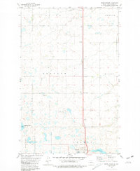 1980 South Prairie1981 Print · USGSWard County's prairie landscape in the early eighties is captured here through its network of townships and small settlements. Local history researchers can trace sites like Saron Ch, the waters of Nelson Lake, and the specific boundaries of a U.S. Military Reservation.
End of results
Showing maps 1-2 of 2
Top cities near South Prairie
- Minot historical maps
- Burlington historical maps
- Surrey historical maps
- Douglas historical maps
- Benedict historical maps
Frequently asked questions
- What are the different types of historical maps available for South Prairie?
- What is the oldest map of South Prairie?
- Where can I purchase historical maps of South Prairie for my home or office?
- Where can I download high-res historical maps of South Prairie?
- Are there historical topographic maps available for South Prairie?
- Is there historical aerial imagery available for South Prairie?
- Where are historical maps of South Prairie sourced from?