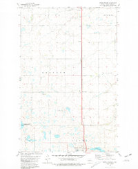
1980 Map of South Prairie
USGS Topo · Published 1981About this map
South Prairie stands as a focal point in this 1980s landscape of Ward County, where the plains are defined by township boundaries such as Afton, Sundre, and Freedom. The terrain is characterized by numerous small prairie potholes and water bodies, including Nelson Lake and the drainage of Kemp Coulée near the settlement of Kemp. This map documents a period of specialized land use, showing a National Waterfowl Production Area and a U.S. Military Reservation alongside traditional rural features like Saron Ch. The local infrastructure reflects a mid-century rural economy with a Gravel Pit, a Radio Tower, and the central north-south corridor of Route 83. The presence of a Sew Disp Pond near the military site indicates developed infrastructure serving specific federal or municipal installations in this North Dakota interior.
Find a feature on this map
17 named features on this map. Tap any name to fly to it.
Don’t see what you’re looking for? This feature index may not catch every label — zoom into the map to look around manually.
Map Details
Editions of this 1980 South Prairie Map
This is the sole edition of this map. No revisions or reprints were ever made.
Other maps of this area

1928 · Minot
USGS Topo · 1:62,500

1929 · Sawyer
USGS Topo · 1:62,500

1929 · Benedict
USGS Topo · 1:62,500

1948 · Minot NW
USGS Topo · 1:24,000

1948 · Surrey
USGS Topo · 1:24,000

1949 · Minot NW
USGS Topo · 1:24,000

1949 · Surrey
USGS Topo · 1:24,000

1949 · Minot
USGS Topo · 1:24,000

1949 · Sawyer
USGS Topo · 1:62,500
1950 · Sawyer SW
USGS Topo · 1:24,000